![](/images/other/stat-length.png)
![Excursión Senderismo Saint-Pierre-de-Genebroz - Mont Beauvoir - Photo](https://media.geolcdn.com/t/1900/400/ext.pjpeg?maxdim=2&url=https%3A%2F%2Fstatic1.geolcdn.com%2Fsiteimages%2Fupload%2Ffiles%2F1553511878bg_sport_marche.png)
Mont Beauvoir
bruno.saget
Usuario
![Longitud](/images/other/stat-length.png)
Longitud
7 km
![Altitud máxima](https://static1.geolcdn.com/siteimages/upload/files/1508320355ic_sort_altitude_max_24dp.png)
Altitud máxima
1317 m
![Desnivel positivo](https://static1.geolcdn.com/siteimages/upload/files/1508320355ic_sort_den_pos_24dp.png)
Desnivel positivo
475 m
![Km-Effort](/images/other/stat-length.png)
Km-Effort
13,4 km
![Altitud mínima](https://static1.geolcdn.com/siteimages/upload/files/1508320355ic_sort_altitude_min_24dp.png)
Altitud mínima
883 m
![Desnivel negativo](https://static1.geolcdn.com/siteimages/upload/files/1508320355ic_sort_den_neg_24dp.png)
Desnivel negativo
481 m
![Boucle](https://static1.geolcdn.com/siteimages/upload/files/16400158638029165_repeat_loop_refresh_sync_direction_icon.png)
Boucle
Sí
Fecha de creación :
2015-08-23 00:00:00.0
Última modificación :
2015-08-23 00:00:00.0
![Senderismo](https://static1.geolcdn.com/sitytour/trail-icons/101.png)
4h00
Dificultad : Difícil
![Escanee este código QR para abrir la excursión en la aplicación SityTrail](https://capi.geolives.com/qq0zvz2zws4bq2lad0pu/sitytour/trails/461465/qr.png?size=200)
Aplicación GPS de excursión GRATIS
A propósito
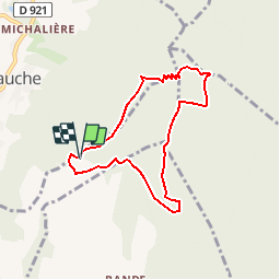
Ruta Senderismo de 7 km a descubrir en Auvergne-Rhône-Alpes, Saboya, Saint-Pierre-de-Genebroz. Esta ruta ha sido propuesta por bruno.saget.
Descripción
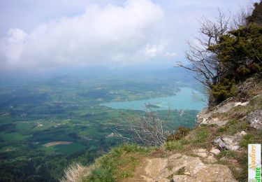
Attention descente difficile hors sentier : il faut descendre vraiment au niveau de Pré Pollet, sinon forte pente houx buis très dense. Vu un jeune chamois à la fin de la barrière rocheuse.
Localización
País:
France
Región :
Auvergne-Rhône-Alpes
Departamento/provincia :
Saboya
Municipio :
Saint-Pierre-de-Genebroz
Localidad:
Unknown
Salida:(Dec)
Salida:(UTM)
717092 ; 5039271 (31T) N.
Comentarios
Excursiones cerca
![Excursión Senderismo Attignat-Oncin - Le Mont Grelle 1425m, depuis Attignat - Oncin - Photo](https://media.geolcdn.com/t/375/260/ext.jpg?maxdim=2&url=https%3A%2F%2Fservices.sitytrail.com%2FGeolivesWS%2FDownloadMedia.ashx%3FTrailID%3D102436%26Media%3D3086_1.jpg)
![Senderismo Senderismo](https://static1.geolcdn.com/sitytour/trail-icons/101.png)
Le Mont Grelle 1425m, depuis Attignat - Oncin
Senderismo
Medio
(3)
Attignat-Oncin,
Auvergne-Rhône-Alpes,
Saboya,
France
![](/images/other/stat-length.png)
9,6 km | 17,6 km-effort
4h 30min
![](https://static1.geolcdn.com/siteimages/upload/files/16400158638029165_repeat_loop_refresh_sync_direction_icon.png)
Sí
![Excursión Bici de carretera Corbel - Entreront - Photo](https://media.geolcdn.com/t/375/260/9b42e589-105e-4d70-99b0-df835d2b48ea.jpg&format=jpg&maxdim=2)
![Bici de carretera Bici de carretera](https://static1.geolcdn.com/sitytour/trail-icons/201.png)
Entreront
Bici de carretera
Muy difícil
(1)
Corbel,
Auvergne-Rhône-Alpes,
Saboya,
France
![](/images/other/stat-length.png)
34 km | 49 km-effort
2h 53min
![](https://static1.geolcdn.com/siteimages/upload/files/16400158638029165_repeat_loop_refresh_sync_direction_icon.png)
Sí
![Excursión Senderismo Saint-Christophe - 38 st Christophe sur guiers grottes guiers vif - Photo](https://media.geolcdn.com/t/375/260/b80de980-1ba2-4651-878b-a9fe13ee8ba9.jpg&format=jpg&maxdim=2)
![Senderismo Senderismo](https://static1.geolcdn.com/sitytour/trail-icons/101.png)
38 st Christophe sur guiers grottes guiers vif
Senderismo
Medio
Saint-Christophe,
Auvergne-Rhône-Alpes,
Saboya,
France
![](/images/other/stat-length.png)
7,3 km | 12,7 km-effort
3h 24min
![](https://static1.geolcdn.com/siteimages/upload/files/16400158638029165_repeat_loop_refresh_sync_direction_icon.png)
Sí
![Excursión Senderismo La Bauche - Ballade vers la Bauche - Photo](https://media.geolcdn.com/t/375/260/beac6041-f762-4265-baf1-b8a107f85ed8.jpg&format=jpg&maxdim=2)
![Senderismo Senderismo](https://static1.geolcdn.com/sitytour/trail-icons/101.png)
Ballade vers la Bauche
Senderismo
Fácil
La Bauche,
Auvergne-Rhône-Alpes,
Saboya,
France
![](/images/other/stat-length.png)
11,7 km | 23 km-effort
6h 19min
![](https://static1.geolcdn.com/siteimages/upload/files/16400158638029165_repeat_loop_refresh_sync_direction_icon.png)
Sí
![Excursión sport Saint-Christophe - La grotte - Photo](https://media.geolcdn.com/t/375/260/7cc75393-f761-46d1-becb-3cd7fb47c0ce.jpg&format=jpg&maxdim=2)
La grotte
sport
Muy fácil
Saint-Christophe,
Auvergne-Rhône-Alpes,
Saboya,
France
![](/images/other/stat-length.png)
8,9 km | 14,1 km-effort
Desconocido
![](https://static1.geolcdn.com/siteimages/upload/files/16400158638029165_repeat_loop_refresh_sync_direction_icon.png)
No
![Excursión Ruta Saint-Christophe - au dessus de la grotte des échelles - Photo](https://media.geolcdn.com/t/375/260/beed80db-3abc-4986-b62a-c1a9ab3b5b40.jpg&format=jpg&maxdim=2)
![Ruta Ruta](https://static1.geolcdn.com/sitytour/trail-icons/104.png)
au dessus de la grotte des échelles
Ruta
Muy fácil
Saint-Christophe,
Auvergne-Rhône-Alpes,
Saboya,
France
![](/images/other/stat-length.png)
8 km | 11,8 km-effort
1h 11min
![](https://static1.geolcdn.com/siteimages/upload/files/16400158638029165_repeat_loop_refresh_sync_direction_icon.png)
Sí
![Excursión Ruta La Bauche - Mont Beauvoir - Photo](https://media.geolcdn.com/t/375/260/d3426012-2a94-4a47-accc-9d6f7ade0a85.jpg&format=jpg&maxdim=2)
![Ruta Ruta](https://static1.geolcdn.com/sitytour/trail-icons/104.png)
Mont Beauvoir
Ruta
Fácil
La Bauche,
Auvergne-Rhône-Alpes,
Saboya,
France
![](/images/other/stat-length.png)
9,2 km | 18,7 km-effort
1h 47min
![](https://static1.geolcdn.com/siteimages/upload/files/16400158638029165_repeat_loop_refresh_sync_direction_icon.png)
Sí
![Senderismo Senderismo](https://static1.geolcdn.com/sitytour/trail-icons/101.png)
la voie SARDE / tunnel des l'Echelles /st Christophe sur Guiers
Senderismo
Muy difícil
Saint-Christophe,
Auvergne-Rhône-Alpes,
Saboya,
France
![](/images/other/stat-length.png)
15,1 km | 23 km-effort
5h 12min
![](https://static1.geolcdn.com/siteimages/upload/files/16400158638029165_repeat_loop_refresh_sync_direction_icon.png)
Sí
![Excursión Senderismo Saint-Christophe - 190323 Boucle voie Sarde - Photo](https://media.geolcdn.com/t/375/260/73c09b18-e12a-4062-a718-c9e9afd93b05.jpg&format=jpg&maxdim=2)
![Senderismo Senderismo](https://static1.geolcdn.com/sitytour/trail-icons/101.png)
190323 Boucle voie Sarde
Senderismo
Difícil
Saint-Christophe,
Auvergne-Rhône-Alpes,
Saboya,
France
![](/images/other/stat-length.png)
9,7 km | 15,6 km-effort
3h 50min
![](https://static1.geolcdn.com/siteimages/upload/files/16400158638029165_repeat_loop_refresh_sync_direction_icon.png)
Sí