![](/images/other/stat-length.png)
![Excursión Senderismo Sousceyrac-en-Quercy - Calviac - Photo](https://media.geolcdn.com/t/1900/400/ext.pjpeg?maxdim=2&url=https%3A%2F%2Fstatic1.geolcdn.com%2Fsiteimages%2Fupload%2Ffiles%2F1553511878bg_sport_marche.png)
Calviac
caldefran
Usuario
![Longitud](/images/other/stat-length.png)
Longitud
21 km
![Altitud máxima](https://static1.geolcdn.com/siteimages/upload/files/1508320355ic_sort_altitude_max_24dp.png)
Altitud máxima
642 m
![Desnivel positivo](https://static1.geolcdn.com/siteimages/upload/files/1508320355ic_sort_den_pos_24dp.png)
Desnivel positivo
490 m
![Km-Effort](/images/other/stat-length.png)
Km-Effort
28 km
![Altitud mínima](https://static1.geolcdn.com/siteimages/upload/files/1508320355ic_sort_altitude_min_24dp.png)
Altitud mínima
534 m
![Desnivel negativo](https://static1.geolcdn.com/siteimages/upload/files/1508320355ic_sort_den_neg_24dp.png)
Desnivel negativo
492 m
![Boucle](https://static1.geolcdn.com/siteimages/upload/files/16400158638029165_repeat_loop_refresh_sync_direction_icon.png)
Boucle
Sí
Fecha de creación :
2015-08-20 00:00:00.0
Última modificación :
2015-08-20 00:00:00.0
![Senderismo](https://static1.geolcdn.com/sitytour/trail-icons/101.png)
7h00
Dificultad : Fácil
![Escanee este código QR para abrir la excursión en la aplicación SityTrail](https://capi.geolives.com/qq0zvz2zws4bq2lad0pu/sitytour/trails/461439/qr.png?size=200)
Aplicación GPS de excursión GRATIS
A propósito
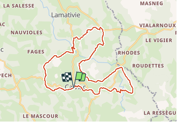
Ruta Senderismo de 21 km a descubrir en Occitania, Lot, Sousceyrac-en-Quercy. Esta ruta ha sido propuesta por caldefran.
Descripción
Départ randonnée : Village de Calviac (Lot 46)Aux confins du Lot, près du Cantal.Belle randonée bien balisée en jaune et décrite dans les topos du CDT du Lot
Localización
País:
France
Región :
Occitania
Departamento/provincia :
Lot
Municipio :
Sousceyrac-en-Quercy
Localidad:
Unknown
Salida:(Dec)
Salida:(UTM)
424780 ; 4974774 (31T) N.
Comentarios
Excursiones cerca
![Excursión Senderismo Sousceyrac-en-Quercy - Calviac circuit - Photo](https://media.geolcdn.com/t/375/260/ext.jpg?maxdim=2&url=https%3A%2F%2Fstatic1.geolcdn.com%2Fsiteimages%2Fupload%2Ffiles%2F1553511878bg_sport_marche.png)
![Senderismo Senderismo](https://static1.geolcdn.com/sitytour/trail-icons/101.png)
Calviac circuit
Senderismo
Fácil
Sousceyrac-en-Quercy,
Occitania,
Lot,
France
![](/images/other/stat-length.png)
17 km | 21 km-effort
3h 39min
![](https://static1.geolcdn.com/siteimages/upload/files/16400158638029165_repeat_loop_refresh_sync_direction_icon.png)
Sí
![Excursión Paseo ecuestre Sousceyrac-en-Quercy - comiac 19 km - Photo](https://media.geolcdn.com/t/375/260/ext.jpg?maxdim=2&url=https%3A%2F%2Fstatic1.geolcdn.com%2Fsiteimages%2Fupload%2Ffiles%2F1524743154cheval.jpg)
![Paseo ecuestre Paseo ecuestre](https://static1.geolcdn.com/sitytour/trail-icons/301.png)
comiac 19 km
Paseo ecuestre
Medio
Sousceyrac-en-Quercy,
Occitania,
Lot,
France
![](/images/other/stat-length.png)
18,9 km | 25 km-effort
3h 3min
![](https://static1.geolcdn.com/siteimages/upload/files/16400158638029165_repeat_loop_refresh_sync_direction_icon.png)
No
![Excursión Senderismo Sousceyrac-en-Quercy - Comiac-lamativie - Photo](https://media.geolcdn.com/t/375/260/ext.jpg?maxdim=2&url=https%3A%2F%2Fstatic1.geolcdn.com%2Fsiteimages%2Fupload%2Ffiles%2F1553511878bg_sport_marche.png)
![Senderismo Senderismo](https://static1.geolcdn.com/sitytour/trail-icons/101.png)
Comiac-lamativie
Senderismo
Medio
Sousceyrac-en-Quercy,
Occitania,
Lot,
France
![](/images/other/stat-length.png)
11 km | 15,8 km-effort
2h 16min
![](https://static1.geolcdn.com/siteimages/upload/files/16400158638029165_repeat_loop_refresh_sync_direction_icon.png)
No
![Excursión Senderismo Sousceyrac-en-Quercy - calviac - Photo](https://media.geolcdn.com/t/375/260/ext.jpg?maxdim=2&url=https%3A%2F%2Fstatic1.geolcdn.com%2Fsiteimages%2Fupload%2Ffiles%2F1553511878bg_sport_marche.png)
![Senderismo Senderismo](https://static1.geolcdn.com/sitytour/trail-icons/101.png)
calviac
Senderismo
Difícil
Sousceyrac-en-Quercy,
Occitania,
Lot,
France
![](/images/other/stat-length.png)
13,4 km | 17,1 km-effort
3h 46min
![](https://static1.geolcdn.com/siteimages/upload/files/16400158638029165_repeat_loop_refresh_sync_direction_icon.png)
Sí
![Excursión Paseo ecuestre Sousceyrac-en-Quercy - Cavaliers Comiac 2022 - Photo](https://media.geolcdn.com/t/375/260/ext.jpg?maxdim=2&url=https%3A%2F%2Fstatic1.geolcdn.com%2Fsiteimages%2Fupload%2Ffiles%2F1524743154cheval.jpg)
![Paseo ecuestre Paseo ecuestre](https://static1.geolcdn.com/sitytour/trail-icons/301.png)
Cavaliers Comiac 2022
Paseo ecuestre
Medio
Sousceyrac-en-Quercy,
Occitania,
Lot,
France
![](/images/other/stat-length.png)
21 km | 27 km-effort
1h 4min
![](https://static1.geolcdn.com/siteimages/upload/files/16400158638029165_repeat_loop_refresh_sync_direction_icon.png)
Sí
![Excursión Enganche Sousceyrac-en-Quercy - Comiac attelages 2022 bis - Photo](https://media.geolcdn.com/t/375/260/ext.jpg?maxdim=2&url=https%3A%2F%2Fstatic1.geolcdn.com%2Fsiteimages%2Fupload%2Ffiles%2F1524743154cheval.jpg)
![Enganche Enganche](https://static1.geolcdn.com/sitytour/trail-icons/302.png)
Comiac attelages 2022 bis
Enganche
Sousceyrac-en-Quercy,
Occitania,
Lot,
France
![](/images/other/stat-length.png)
21 km | 27 km-effort
1h 1min
![](https://static1.geolcdn.com/siteimages/upload/files/16400158638029165_repeat_loop_refresh_sync_direction_icon.png)
Sí
![Excursión Paseo ecuestre Sousceyrac-en-Quercy - Cavaliers Comiac 2022 - Photo](https://media.geolcdn.com/t/375/260/ext.jpg?maxdim=2&url=https%3A%2F%2Fstatic1.geolcdn.com%2Fsiteimages%2Fupload%2Ffiles%2F1524743154cheval.jpg)
![Paseo ecuestre Paseo ecuestre](https://static1.geolcdn.com/sitytour/trail-icons/301.png)
Cavaliers Comiac 2022
Paseo ecuestre
Medio
Sousceyrac-en-Quercy,
Occitania,
Lot,
France
![](/images/other/stat-length.png)
18,7 km | 24 km-effort
1h 7min
![](https://static1.geolcdn.com/siteimages/upload/files/16400158638029165_repeat_loop_refresh_sync_direction_icon.png)
Sí
![Excursión Enganche Sousceyrac-en-Quercy - Comiac attelages PROJET 2022 SAMEDI - Photo](https://media.geolcdn.com/t/375/260/ext.jpg?maxdim=2&url=https%3A%2F%2Fstatic1.geolcdn.com%2Fsiteimages%2Fupload%2Ffiles%2F1524743154cheval.jpg)
![Enganche Enganche](https://static1.geolcdn.com/sitytour/trail-icons/302.png)
Comiac attelages PROJET 2022 SAMEDI
Enganche
Muy fácil
Sousceyrac-en-Quercy,
Occitania,
Lot,
France
![](/images/other/stat-length.png)
18,2 km | 23 km-effort
Desconocido
![](https://static1.geolcdn.com/siteimages/upload/files/16400158638029165_repeat_loop_refresh_sync_direction_icon.png)
Sí
![Excursión A pie Sousceyrac-en-Quercy - COMIAC A PIED - Photo](https://media.geolcdn.com/t/375/260/ext.jpg?maxdim=2&url=https%3A%2F%2Fstatic1.geolcdn.com%2Fsiteimages%2Fupload%2Ffiles%2F1545311037marcheuse_200dpi.jpg)
![A pie A pie](https://static1.geolcdn.com/sitytour/trail-icons/100.png)
COMIAC A PIED
A pie
Muy fácil
Sousceyrac-en-Quercy,
Occitania,
Lot,
France
![](/images/other/stat-length.png)
13,2 km | 16,1 km-effort
Desconocido
![](https://static1.geolcdn.com/siteimages/upload/files/16400158638029165_repeat_loop_refresh_sync_direction_icon.png)
Sí