![](/images/other/stat-length.png)
![Excursión Otra actividad Volvic - camping pierre et source Volvic_ND de la garde_chateau de tournoel_source de volvic - Photo](https://media.geolcdn.com/t/1900/400/ext.pjpeg?maxdim=2&url=https%3A%2F%2Fstatic1.geolcdn.com%2Fsiteimages%2Fupload%2Ffiles%2F1545311037marcheuse_200dpi.jpg)
camping pierre et source Volvic_ND de la garde_chateau de tournoel_source de volvic
guariso
Usuario
![Longitud](/images/other/stat-length.png)
![Altitud máxima](https://static1.geolcdn.com/siteimages/upload/files/1508320355ic_sort_altitude_max_24dp.png)
![Desnivel positivo](https://static1.geolcdn.com/siteimages/upload/files/1508320355ic_sort_den_pos_24dp.png)
![Km-Effort](/images/other/stat-length.png)
![Altitud mínima](https://static1.geolcdn.com/siteimages/upload/files/1508320355ic_sort_altitude_min_24dp.png)
![Desnivel negativo](https://static1.geolcdn.com/siteimages/upload/files/1508320355ic_sort_den_neg_24dp.png)
![Boucle](https://static1.geolcdn.com/siteimages/upload/files/16400158638029165_repeat_loop_refresh_sync_direction_icon.png)
![Otra actividad](https://static1.geolcdn.com/sitytour/trail-icons/900.png)
2h33
Dificultad : Medio
![Escanee este código QR para abrir la excursión en la aplicación SityTrail](https://capi.geolives.com/qq0zvz2zws4bq2lad0pu/sitytour/trails/458923/qr.png?size=200)
Aplicación GPS de excursión GRATIS
A propósito
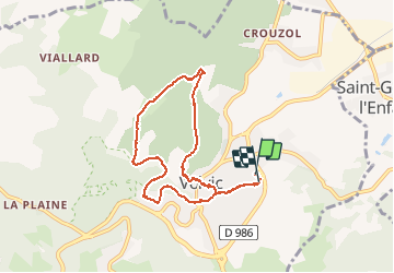
Ruta Otra actividad de 7,7 km a descubrir en Auvergne-Rhône-Alpes, Puy-de-Dôme, Volvic. Esta ruta ha sido propuesta por guariso.
Descripción
La balade démarre au camping pierre et sources à volvic, on se dirige vers Volvic en traversant un jardin en contrebas de l'église, on peut visiter l'église vestige clunisien, puis se diriger vers les hauteurs, le circuit emprunté le chemin de croix (un peu délicat vers le fin, prévoir de bonnes chaussures). Notre dame de la garde permet de contempler un paysage magnifique. Le chemin se poursuit en sous bois et descend en pente douce jusqu'au château de tournoel_source que l'on peut visiter au passage (prévoir une heure et env 8euros pour un adulte). Des tables de pic Nicolas en contrebas du château. Le chemin repart sur le gr avec une montée sur un chemin large mais rocailleux. A l'issue de la boucle on arrive aux sources de volvic. L'espace d'information permet de découvrir le lieu (prévoir 30 minutes),. La descente vers volvic se fait par un petit chemin bordé par des jardins.
Localización
Comentarios
Excursiones cerca
![Excursión Senderismo Blanzat - Blanzat_Plateau_Bade - Photo](https://media.geolcdn.com/t/375/260/0f6960c3-6461-4500-bc08-d408282d7c8a.jpg&format=jpg&maxdim=2)
![Senderismo Senderismo](https://static1.geolcdn.com/sitytour/trail-icons/101.png)
Senderismo
![](/images/other/stat-length.png)
![](https://static1.geolcdn.com/siteimages/upload/files/16400158638029165_repeat_loop_refresh_sync_direction_icon.png)
![Excursión Senderismo Chanat-la-Mouteyre - Chanat_Trois_Villages - Photo](https://media.geolcdn.com/t/375/260/f6aed3b2-f876-470f-b6b5-0e9d2ed9b804.jpg&format=jpg&maxdim=2)
![Senderismo Senderismo](https://static1.geolcdn.com/sitytour/trail-icons/101.png)
Senderismo
![](/images/other/stat-length.png)
![](https://static1.geolcdn.com/siteimages/upload/files/16400158638029165_repeat_loop_refresh_sync_direction_icon.png)
![Excursión Senderismo Enval - Enval_Gorges - Photo](https://media.geolcdn.com/t/375/260/6439ff7d-6f0e-45b4-9186-1ec0cb9dacc2.jpg&format=jpg&maxdim=2)
![Senderismo Senderismo](https://static1.geolcdn.com/sitytour/trail-icons/101.png)
Senderismo
![](/images/other/stat-length.png)
![](https://static1.geolcdn.com/siteimages/upload/files/16400158638029165_repeat_loop_refresh_sync_direction_icon.png)
![Excursión Senderismo Châtel-Guyon - Chazeron sans souci - Photo](https://media.geolcdn.com/t/375/260/ext.jpg?maxdim=2&url=https%3A%2F%2Fservices.sitytrail.com%2FGeolivesWS%2FDownloadMedia.ashx%3FTrailID%3D324974%26Media%3Dfix__20140716162721.jpg)
![Senderismo Senderismo](https://static1.geolcdn.com/sitytour/trail-icons/101.png)
Senderismo
![](/images/other/stat-length.png)
![](https://static1.geolcdn.com/siteimages/upload/files/16400158638029165_repeat_loop_refresh_sync_direction_icon.png)
![Excursión Senderismo Châtel-Guyon - Boucle de Rochepradière en passant par Douhady - Photo](https://media.geolcdn.com/t/375/260/ext.jpg?maxdim=2&url=https%3A%2F%2Fservices.sitytrail.com%2FGeolivesWS%2FDownloadMedia.ashx%3FTrailID%3D320023%26Media%3Dfix__20140701160258.jpg)
![Senderismo Senderismo](https://static1.geolcdn.com/sitytour/trail-icons/101.png)
Senderismo
![](/images/other/stat-length.png)
![](https://static1.geolcdn.com/siteimages/upload/files/16400158638029165_repeat_loop_refresh_sync_direction_icon.png)
![Excursión Senderismo Châtel-Guyon - Le tour de Montaclier - Saint Hippolyte - Photo](https://media.geolcdn.com/t/375/260/ext.jpg?maxdim=2&url=https%3A%2F%2Fservices.sitytrail.com%2FGeolivesWS%2FDownloadMedia.ashx%3FTrailID%3D317669%26Media%3D16954_5.jpg)
![Senderismo Senderismo](https://static1.geolcdn.com/sitytour/trail-icons/101.png)
Senderismo
![](/images/other/stat-length.png)
![](https://static1.geolcdn.com/siteimages/upload/files/16400158638029165_repeat_loop_refresh_sync_direction_icon.png)
![Excursión Bici de montaña Volvic - Tour du Puy de Dôme en VTT - Photo](https://media.geolcdn.com/t/375/260/ext.jpg?maxdim=2&url=https%3A%2F%2Fservices.sitytrail.com%2FGeolivesWS%2FDownloadMedia.ashx%3FTrailID%3D191407%26Media%3D14983_4.jpg)
![Bici de montaña Bici de montaña](https://static1.geolcdn.com/sitytour/trail-icons/202.png)
Bici de montaña
![](/images/other/stat-length.png)
![](https://static1.geolcdn.com/siteimages/upload/files/16400158638029165_repeat_loop_refresh_sync_direction_icon.png)
![Excursión Senderismo Volvic - Les sources de Volvic - Photo](https://media.geolcdn.com/t/375/260/ext.jpg?maxdim=2&url=https%3A%2F%2Fservices.sitytrail.com%2FGeolivesWS%2FDownloadMedia.ashx%3FTrailID%3D102879%26Media%3D4090_1.jpg)
![Senderismo Senderismo](https://static1.geolcdn.com/sitytour/trail-icons/101.png)
Senderismo
![](/images/other/stat-length.png)
![](https://static1.geolcdn.com/siteimages/upload/files/16400158638029165_repeat_loop_refresh_sync_direction_icon.png)
![Excursión Senderismo Volvic - Egaules (près de Luzet) - Photo](https://media.geolcdn.com/t/375/260/ext.jpg?maxdim=2&url=https%3A%2F%2Fservices.sitytrail.com%2FGeolivesWS%2FDownloadMedia.ashx%3FTrailID%3D101845%26Media%3D2131_1.jpg)
![Senderismo Senderismo](https://static1.geolcdn.com/sitytour/trail-icons/101.png)
Senderismo
![](/images/other/stat-length.png)
![](https://static1.geolcdn.com/siteimages/upload/files/16400158638029165_repeat_loop_refresh_sync_direction_icon.png)