![](/images/other/stat-length.png)
![Excursión Senderismo Maasmechelen - Mechelse Heide - Photo](https://media.geolcdn.com/t/1900/400/ext.pjpeg?maxdim=2&url=https%3A%2F%2Fservices.sitytrail.com%2FGeolivesWS%2FDownloadMedia.ashx%3FTrailID%3D452278%26Media%3D20150731142522.jpg)
Mechelse Heide
mavbelgium
Usuario
![Longitud](/images/other/stat-length.png)
Longitud
18,7 km
![Altitud máxima](https://static1.geolcdn.com/siteimages/upload/files/1508320355ic_sort_altitude_max_24dp.png)
Altitud máxima
97 m
![Desnivel positivo](https://static1.geolcdn.com/siteimages/upload/files/1508320355ic_sort_den_pos_24dp.png)
Desnivel positivo
227 m
![Km-Effort](/images/other/stat-length.png)
Km-Effort
22 km
![Altitud mínima](https://static1.geolcdn.com/siteimages/upload/files/1508320355ic_sort_altitude_min_24dp.png)
Altitud mínima
57 m
![Desnivel negativo](https://static1.geolcdn.com/siteimages/upload/files/1508320355ic_sort_den_neg_24dp.png)
Desnivel negativo
200 m
![Boucle](https://static1.geolcdn.com/siteimages/upload/files/16400158638029165_repeat_loop_refresh_sync_direction_icon.png)
Boucle
No
Fecha de creación :
2015-07-31 00:00:00.0
Última modificación :
2015-07-31 00:00:00.0
![Senderismo](https://static1.geolcdn.com/sitytour/trail-icons/101.png)
2h40
Dificultad : Fácil
![Escanee este código QR para abrir la excursión en la aplicación SityTrail](https://capi.geolives.com/qq0zvz2zws4bq2lad0pu/sitytour/trails/452278/qr.png?size=200)
Aplicación GPS de excursión GRATIS
A propósito
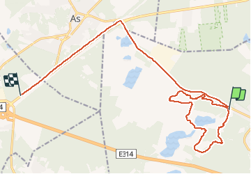
Ruta Senderismo de 18,7 km a descubrir en Flandes, Limburgo, Maasmechelen. Esta ruta ha sido propuesta por mavbelgium.
Descripción
mooie tocht van 10 km door Mechelse Heide.. matig pittig door de steile (korte) hellingen/trappen. Mooi zicht van de streek op hoogste punt vd wandeling
Localización
País:
Belgium
Región :
Flandes
Departamento/provincia :
Limburgo
Municipio :
Maasmechelen
Localidad:
Mechelen-aan-de-Maas
Salida:(Dec)
Salida:(UTM)
686650 ; 5650730 (31U) N.
Comentarios
Excursiones cerca
![Excursión Senderismo Maasmechelen - Mechelse Heide - Photo](https://media.geolcdn.com/t/375/260/501f02e9-8086-4be8-98c9-f01120ddee06.jpg&format=jpg&maxdim=2)
![Senderismo Senderismo](https://static1.geolcdn.com/sitytour/trail-icons/101.png)
Mechelse Heide
Senderismo
Fácil
(2)
Maasmechelen,
Flandes,
Limburgo,
Belgium
![](/images/other/stat-length.png)
14,2 km | 16,2 km-effort
3h 41min
![](https://static1.geolcdn.com/siteimages/upload/files/16400158638029165_repeat_loop_refresh_sync_direction_icon.png)
Sí
![Excursión A pie As - Mechelse Heide Noord - Photo](https://media.geolcdn.com/t/375/260/6c3d6be9-86c4-472e-82c2-64c07d2c49aa.jpeg&format=jpg&maxdim=2)
![A pie A pie](https://static1.geolcdn.com/sitytour/trail-icons/100.png)
![Excursión A pie Maasmechelen - Erfgoedwandeling Eisden Tuinwijk - Photo](https://media.geolcdn.com/t/375/260/28db0122-7bbc-4a11-ae3a-faea898e04f5.jpeg&format=jpg&maxdim=2)
![A pie A pie](https://static1.geolcdn.com/sitytour/trail-icons/100.png)
Erfgoedwandeling Eisden Tuinwijk
A pie
Fácil
Maasmechelen,
Flandes,
Limburgo,
Belgium
![](/images/other/stat-length.png)
3,1 km | 3,3 km-effort
44min
![](https://static1.geolcdn.com/siteimages/upload/files/16400158638029165_repeat_loop_refresh_sync_direction_icon.png)
Sí
![Excursión A pie Dilsen-Stokkem - Connecterra Rode driehoek - Photo](https://media.geolcdn.com/t/375/260/5eb5c103-eb27-4a59-83d3-dfd2672ebb0c.jpeg&format=jpg&maxdim=2)
![A pie A pie](https://static1.geolcdn.com/sitytour/trail-icons/100.png)
Connecterra Rode driehoek
A pie
Fácil
Dilsen-Stokkem,
Flandes,
Limburgo,
Belgium
![](/images/other/stat-length.png)
6,2 km | 7 km-effort
1h 35min
![](https://static1.geolcdn.com/siteimages/upload/files/16400158638029165_repeat_loop_refresh_sync_direction_icon.png)
No
![Excursión A pie Maasmechelen - Station As Groene rechthoek - Photo](https://media.geolcdn.com/t/375/260/6c3d6be9-86c4-472e-82c2-64c07d2c49aa.jpeg&format=jpg&maxdim=2)
![A pie A pie](https://static1.geolcdn.com/sitytour/trail-icons/100.png)
Station As Groene rechthoek
A pie
Fácil
Maasmechelen,
Flandes,
Limburgo,
Belgium
![](/images/other/stat-length.png)
3,3 km | 3,8 km-effort
51min
![](https://static1.geolcdn.com/siteimages/upload/files/16400158638029165_repeat_loop_refresh_sync_direction_icon.png)
Sí
![Excursión A pie Maasmechelen - Leut & Meeswijk Gele zeshoek - Photo](https://media.geolcdn.com/t/375/260/3a349166-7856-4cc9-a007-a2d01b733e80.jpeg&format=jpg&maxdim=2)
![A pie A pie](https://static1.geolcdn.com/sitytour/trail-icons/100.png)
Leut & Meeswijk Gele zeshoek
A pie
Fácil
Maasmechelen,
Flandes,
Limburgo,
Belgium
![](/images/other/stat-length.png)
7 km | 7,4 km-effort
1h 40min
![](https://static1.geolcdn.com/siteimages/upload/files/16400158638029165_repeat_loop_refresh_sync_direction_icon.png)
Sí
![Excursión A pie Maasmechelen - Station As Blauwe ruit - Photo](https://media.geolcdn.com/t/375/260/6c3d6be9-86c4-472e-82c2-64c07d2c49aa.jpeg&format=jpg&maxdim=2)
![A pie A pie](https://static1.geolcdn.com/sitytour/trail-icons/100.png)
Station As Blauwe ruit
A pie
Fácil
Maasmechelen,
Flandes,
Limburgo,
Belgium
![](/images/other/stat-length.png)
6,5 km | 7,1 km-effort
1h 36min
![](https://static1.geolcdn.com/siteimages/upload/files/16400158638029165_repeat_loop_refresh_sync_direction_icon.png)
Sí
![Excursión A pie Maasmechelen - Station As Rode driehoek - Photo](https://media.geolcdn.com/t/375/260/6649a029-f07f-4f45-b4d8-2b574463e7fd.jpeg&format=jpg&maxdim=2)
![A pie A pie](https://static1.geolcdn.com/sitytour/trail-icons/100.png)
Station As Rode driehoek
A pie
Fácil
Maasmechelen,
Flandes,
Limburgo,
Belgium
![](/images/other/stat-length.png)
12 km | 13,4 km-effort
3h 3min
![](https://static1.geolcdn.com/siteimages/upload/files/16400158638029165_repeat_loop_refresh_sync_direction_icon.png)
Sí
![Excursión A pie Dilsen-Stokkem - Litzberg groene rechthoek - Photo](https://media.geolcdn.com/t/375/260/085d16b1-ffd1-4281-a4d3-38ce31d4ff24.jpeg&format=jpg&maxdim=2)
![A pie A pie](https://static1.geolcdn.com/sitytour/trail-icons/100.png)
Litzberg groene rechthoek
A pie
Fácil
Dilsen-Stokkem,
Flandes,
Limburgo,
Belgium
![](/images/other/stat-length.png)
3 km | 3,7 km-effort
49min
![](https://static1.geolcdn.com/siteimages/upload/files/16400158638029165_repeat_loop_refresh_sync_direction_icon.png)
Sí