![](/images/other/stat-length.png)
![Excursión Senderismo Saint-Étienne-de-Tinée - mont TENIBRE - Photo](https://media.geolcdn.com/t/1900/400/ext.pjpeg?maxdim=2&url=https%3A%2F%2Fstatic1.geolcdn.com%2Fsiteimages%2Fupload%2Ffiles%2F1553511878bg_sport_marche.png)
mont TENIBRE
fredopaca
Usuario
![Longitud](/images/other/stat-length.png)
![Altitud máxima](https://static1.geolcdn.com/siteimages/upload/files/1508320355ic_sort_altitude_max_24dp.png)
![Desnivel positivo](https://static1.geolcdn.com/siteimages/upload/files/1508320355ic_sort_den_pos_24dp.png)
![Km-Effort](/images/other/stat-length.png)
![Altitud mínima](https://static1.geolcdn.com/siteimages/upload/files/1508320355ic_sort_altitude_min_24dp.png)
![Desnivel negativo](https://static1.geolcdn.com/siteimages/upload/files/1508320355ic_sort_den_neg_24dp.png)
![Boucle](https://static1.geolcdn.com/siteimages/upload/files/16400158638029165_repeat_loop_refresh_sync_direction_icon.png)
![Senderismo](https://static1.geolcdn.com/sitytour/trail-icons/101.png)
9h47
Dificultad : Difícil
![Escanee este código QR para abrir la excursión en la aplicación SityTrail](https://capi.geolives.com/qq0zvz2zws4bq2lad0pu/sitytour/trails/445933/qr.png?size=200)
Aplicación GPS de excursión GRATIS
A propósito
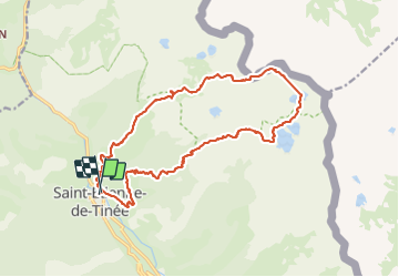
Ruta Senderismo de 20 km a descubrir en Provenza-Alpes-Costa Azul, Alpes Marítimos, Saint-Étienne-de-Tinée. Esta ruta ha sido propuesta por fredopaca.
Descripción
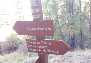
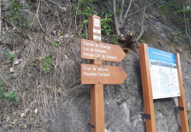
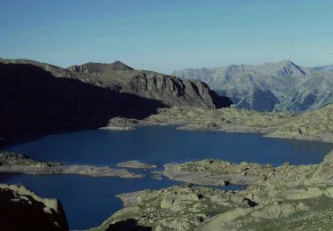
départ St Étienne de tinée balise 100 boucle retour final balise 108 vers le refuge de rabuons long ascension sur chemin l'énergie lac de Rabuons très joli couleurs nous remontons sur lac cimon et grimpette sur le pas de rabuons la dernière montée sur le mont Ténibre marquage bien distincte avec balisage rouge de nos amis Italiens avec plusieurs options ensuite descente vers les lacs varicles plan de tenibre balise 111 reprendre la balise 112 descendre vers 109 vers la 108 au final
Localización
Comentarios
Excursiones cerca
![Excursión Senderismo Saint-Étienne-de-Tinée - MERCANTOUR - Lac de rabuons - Photo](https://media.geolcdn.com/t/375/260/9be970a9-36fb-4800-8850-f3d8a283d146.jpg&format=jpg&maxdim=2)
![Senderismo Senderismo](https://static1.geolcdn.com/sitytour/trail-icons/101.png)
Senderismo
![](/images/other/stat-length.png)
![](https://static1.geolcdn.com/siteimages/upload/files/16400158638029165_repeat_loop_refresh_sync_direction_icon.png)
![Excursión Senderismo Saint-Étienne-de-Tinée - Mont Ténibre en boucle depuis Saint Etienne de Tinée - Photo](https://media.geolcdn.com/t/375/260/ext.jpg?maxdim=2&url=https%3A%2F%2Fservices.sitytrail.com%2FGeolivesWS%2FDownloadMedia.ashx%3FTrailID%3D316962%26Media%3D16081_1.jpg)
![Senderismo Senderismo](https://static1.geolcdn.com/sitytour/trail-icons/101.png)
Senderismo
![](/images/other/stat-length.png)
![](https://static1.geolcdn.com/siteimages/upload/files/16400158638029165_repeat_loop_refresh_sync_direction_icon.png)
![Excursión Senderismo Saint-Étienne-de-Tinée - Lacs de Rabuons et Chaffour - Photo](https://media.geolcdn.com/t/375/260/3c095966-4d41-4343-af9e-eff2f1957790.jpg&format=jpg&maxdim=2)
![Senderismo Senderismo](https://static1.geolcdn.com/sitytour/trail-icons/101.png)
Senderismo
![](/images/other/stat-length.png)
![](https://static1.geolcdn.com/siteimages/upload/files/16400158638029165_repeat_loop_refresh_sync_direction_icon.png)
![Excursión Senderismo Saint-Étienne-de-Tinée - Refuge du Rabuons -- Mt Ténibre A/R -- St Etienne de Tinée - Photo](https://media.geolcdn.com/t/375/260/994ef0cf-20db-466f-991e-cc6124ac559b.jpg&format=jpg&maxdim=2)
![Senderismo Senderismo](https://static1.geolcdn.com/sitytour/trail-icons/101.png)
Senderismo
![](/images/other/stat-length.png)
![](https://static1.geolcdn.com/siteimages/upload/files/16400158638029165_repeat_loop_refresh_sync_direction_icon.png)
![Excursión A pie Saint-Étienne-de-Tinée - Circuit du Bois d'Anelle - Photo](https://media.geolcdn.com/t/375/260/33170b65-b2a2-4258-939b-53929311e4fe.jpeg&format=jpg&maxdim=2)
![A pie A pie](https://static1.geolcdn.com/sitytour/trail-icons/100.png)
A pie
![](/images/other/stat-length.png)
![](https://static1.geolcdn.com/siteimages/upload/files/16400158638029165_repeat_loop_refresh_sync_direction_icon.png)
![Excursión A pie Saint-Étienne-de-Tinée - Circuit de Selasse - Photo](https://media.geolcdn.com/t/375/260/dfb717e2-6ad9-4c5c-8a23-b53a05088fa8.jpeg&format=jpg&maxdim=2)
![A pie A pie](https://static1.geolcdn.com/sitytour/trail-icons/100.png)
A pie
![](/images/other/stat-length.png)
![](https://static1.geolcdn.com/siteimages/upload/files/16400158638029165_repeat_loop_refresh_sync_direction_icon.png)
![Excursión A pie Saint-Étienne-de-Tinée - Cime de la Bercha - Photo](https://media.geolcdn.com/t/375/260/06e4d46f-e317-406d-bd2c-01041e541c38.jpeg&format=jpg&maxdim=2)
![A pie A pie](https://static1.geolcdn.com/sitytour/trail-icons/100.png)
A pie
![](/images/other/stat-length.png)
![](https://static1.geolcdn.com/siteimages/upload/files/16400158638029165_repeat_loop_refresh_sync_direction_icon.png)
![Excursión A pie Saint-Étienne-de-Tinée - Chemin de l'Energie - Etape 3 - Photo](https://media.geolcdn.com/t/375/260/45dc2ef9-a27b-439a-8012-c03ab217c2f9.jpeg&format=jpg&maxdim=2)
![A pie A pie](https://static1.geolcdn.com/sitytour/trail-icons/100.png)
A pie
![](/images/other/stat-length.png)
![](https://static1.geolcdn.com/siteimages/upload/files/16400158638029165_repeat_loop_refresh_sync_direction_icon.png)
![Excursión A pie Saint-Étienne-de-Tinée - Mont Ténibre - Photo](https://media.geolcdn.com/t/375/260/e4d2ef1c-7332-48ac-8d35-d330e68b6f30.jpeg&format=jpg&maxdim=2)
![A pie A pie](https://static1.geolcdn.com/sitytour/trail-icons/100.png)
A pie
![](/images/other/stat-length.png)
![](https://static1.geolcdn.com/siteimages/upload/files/16400158638029165_repeat_loop_refresh_sync_direction_icon.png)