![](/images/other/stat-length.png)
![Excursión Caballo Hambers - Les Chevaux du Montaigu_12_07_15 - Photo](https://media.geolcdn.com/t/1900/400/ext.pjpeg?maxdim=2&url=https%3A%2F%2Fstatic1.geolcdn.com%2Fsiteimages%2Fupload%2Ffiles%2F1524743154cheval.jpg)
Les Chevaux du Montaigu_12_07_15
mimi53
Usuario
![Longitud](/images/other/stat-length.png)
Longitud
27 km
![Altitud máxima](https://static1.geolcdn.com/siteimages/upload/files/1508320355ic_sort_altitude_max_24dp.png)
Altitud máxima
340 m
![Desnivel positivo](https://static1.geolcdn.com/siteimages/upload/files/1508320355ic_sort_den_pos_24dp.png)
Desnivel positivo
504 m
![Km-Effort](/images/other/stat-length.png)
Km-Effort
34 km
![Altitud mínima](https://static1.geolcdn.com/siteimages/upload/files/1508320355ic_sort_altitude_min_24dp.png)
Altitud mínima
130 m
![Desnivel negativo](https://static1.geolcdn.com/siteimages/upload/files/1508320355ic_sort_den_neg_24dp.png)
Desnivel negativo
509 m
![Boucle](https://static1.geolcdn.com/siteimages/upload/files/16400158638029165_repeat_loop_refresh_sync_direction_icon.png)
Boucle
No
Fecha de creación :
2019-02-23 20:41:34.219
Última modificación :
2019-02-23 20:41:34.382
![Caballo](https://static1.geolcdn.com/sitytour/trail-icons/300.png)
4h12
Dificultad : Medio
![Escanee este código QR para abrir la excursión en la aplicación SityTrail](https://capi.geolives.com/qq0zvz2zws4bq2lad0pu/sitytour/trails/444524/qr.png?size=200)
Aplicación GPS de excursión GRATIS
A propósito
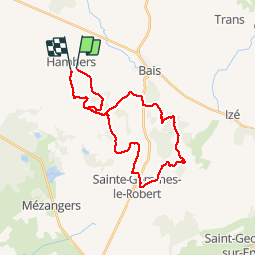
Ruta Caballo de 27 km a descubrir en Países del Loira, Mayenne, Hambers. Esta ruta ha sido propuesta por mimi53.
Descripción
Randonnée Annuelle des Chevaux du Montaigu le 12 juillet 2015 au départ d'hambers pour une très belle rando sur les buttes du Rochard
Localización
País:
France
Región :
Países del Loira
Departamento/provincia :
Mayenne
Municipio :
Hambers
Localidad:
Unknown
Salida:(Dec)
Salida:(UTM)
691940 ; 5347538 (30U) N.
Comentarios
Excursiones cerca
![Excursión A pie Bais - La Mayenne dans un écrin - Photo](https://media.geolcdn.com/t/375/260/819ab20d-9411-4256-a908-8776f3c1f631.jpeg&format=jpg&maxdim=2)
![A pie A pie](https://static1.geolcdn.com/sitytour/trail-icons/100.png)
La Mayenne dans un écrin
A pie
Medio
Bais,
Países del Loira,
Mayenne,
France
![](/images/other/stat-length.png)
22 km | 27 km-effort
6h 12min
![](https://static1.geolcdn.com/siteimages/upload/files/16400158638029165_repeat_loop_refresh_sync_direction_icon.png)
Sí
![Excursión A pie Bais - Balcon sur l'Aron - Photo](https://media.geolcdn.com/t/375/260/83c2ab66-6b3a-40f1-acba-ecff737de16b.jpeg&format=jpg&maxdim=2)
![A pie A pie](https://static1.geolcdn.com/sitytour/trail-icons/100.png)
Balcon sur l'Aron
A pie
Fácil
Bais,
Países del Loira,
Mayenne,
France
![](/images/other/stat-length.png)
15,9 km | 20 km-effort
4h 32min
![](https://static1.geolcdn.com/siteimages/upload/files/16400158638029165_repeat_loop_refresh_sync_direction_icon.png)
Sí
![Excursión Senderismo Hambers - Hambers Montaigu et retour - Photo](https://media.geolcdn.com/t/375/260/9985b358-fed6-4140-80f0-73e7344da834.jpg&format=jpg&maxdim=2)
![Senderismo Senderismo](https://static1.geolcdn.com/sitytour/trail-icons/101.png)
Hambers Montaigu et retour
Senderismo
Medio
Hambers,
Países del Loira,
Mayenne,
France
![](/images/other/stat-length.png)
15 km | 18,6 km-effort
6h 11min
![](https://static1.geolcdn.com/siteimages/upload/files/16400158638029165_repeat_loop_refresh_sync_direction_icon.png)
Sí
![Excursión Senderismo Bais - Bais Marche à pied - Photo](https://media.geolcdn.com/t/375/260/ext.jpg?maxdim=2&url=https%3A%2F%2Fstatic1.geolcdn.com%2Fsiteimages%2Fupload%2Ffiles%2F1553511878bg_sport_marche.png)
![Senderismo Senderismo](https://static1.geolcdn.com/sitytour/trail-icons/101.png)
Bais Marche à pied
Senderismo
Medio
Bais,
Países del Loira,
Mayenne,
France
![](/images/other/stat-length.png)
22 km | 29 km-effort
6h 39min
![](https://static1.geolcdn.com/siteimages/upload/files/16400158638029165_repeat_loop_refresh_sync_direction_icon.png)
No
![Excursión Senderismo Hambers - LA MAYENNE DANS UN ECRIN - Photo](https://media.geolcdn.com/t/375/260/ext.jpg?maxdim=2&url=https%3A%2F%2Fstatic1.geolcdn.com%2Fsiteimages%2Fupload%2Ffiles%2F1553511878bg_sport_marche.png)
![Senderismo Senderismo](https://static1.geolcdn.com/sitytour/trail-icons/101.png)
LA MAYENNE DANS UN ECRIN
Senderismo
Muy difícil
Hambers,
Países del Loira,
Mayenne,
France
![](/images/other/stat-length.png)
23 km | 28 km-effort
6h 9min
![](https://static1.geolcdn.com/siteimages/upload/files/16400158638029165_repeat_loop_refresh_sync_direction_icon.png)
Sí
![Excursión Caballo Hambers - Chevaux du Montaigu Hambers à Hardanges Juillet 2014 - Photo](https://media.geolcdn.com/t/375/260/ext.jpg?maxdim=2&url=https%3A%2F%2Fstatic1.geolcdn.com%2Fsiteimages%2Fupload%2Ffiles%2F1524743154cheval.jpg)
![Caballo Caballo](https://static1.geolcdn.com/sitytour/trail-icons/300.png)
Chevaux du Montaigu Hambers à Hardanges Juillet 2014
Caballo
Medio
Hambers,
Países del Loira,
Mayenne,
France
![](/images/other/stat-length.png)
22 km | 27 km-effort
3h 25min
![](https://static1.geolcdn.com/siteimages/upload/files/16400158638029165_repeat_loop_refresh_sync_direction_icon.png)
No
![Excursión Caballo Hambers - Chevaux du Montaigu Hambers 14 juillet 2014 - Photo](https://media.geolcdn.com/t/375/260/ext.jpg?maxdim=2&url=https%3A%2F%2Fstatic1.geolcdn.com%2Fsiteimages%2Fupload%2Ffiles%2F1524743154cheval.jpg)
![Caballo Caballo](https://static1.geolcdn.com/sitytour/trail-icons/300.png)
Chevaux du Montaigu Hambers 14 juillet 2014
Caballo
Fácil
Hambers,
Países del Loira,
Mayenne,
France
![](/images/other/stat-length.png)
24 km | 30 km-effort
3h 44min
![](https://static1.geolcdn.com/siteimages/upload/files/16400158638029165_repeat_loop_refresh_sync_direction_icon.png)
Sí
![Excursión Senderismo Hambers - Marche au Montaigu_01 - Photo](https://media.geolcdn.com/t/375/260/ext.jpg?maxdim=2&url=https%3A%2F%2Fstatic1.geolcdn.com%2Fsiteimages%2Fupload%2Ffiles%2F1553511878bg_sport_marche.png)
![Senderismo Senderismo](https://static1.geolcdn.com/sitytour/trail-icons/101.png)
Marche au Montaigu_01
Senderismo
Fácil
Hambers,
Países del Loira,
Mayenne,
France
![](/images/other/stat-length.png)
4,9 km | 6,6 km-effort
1h 14min
![](https://static1.geolcdn.com/siteimages/upload/files/16400158638029165_repeat_loop_refresh_sync_direction_icon.png)
Sí
![Excursión Senderismo Hambers - Hambers_Bois du Teil - Photo](https://media.geolcdn.com/t/375/260/ext.jpg?maxdim=2&url=https%3A%2F%2Fstatic1.geolcdn.com%2Fsiteimages%2Fupload%2Ffiles%2F1553511878bg_sport_marche.png)
![Senderismo Senderismo](https://static1.geolcdn.com/sitytour/trail-icons/101.png)
Hambers_Bois du Teil
Senderismo
Fácil
Hambers,
Países del Loira,
Mayenne,
France
![](/images/other/stat-length.png)
4,8 km | 6,1 km-effort
1h 50min
![](https://static1.geolcdn.com/siteimages/upload/files/16400158638029165_repeat_loop_refresh_sync_direction_icon.png)
Sí