![](/images/other/stat-length.png)
![Excursión Otra actividad Quarten - Murgsee - Photo](https://media.geolcdn.com/t/1900/400/ext.pjpeg?maxdim=2&url=https%3A%2F%2Fstatic1.geolcdn.com%2Fsiteimages%2Fupload%2Ffiles%2F1545311037marcheuse_200dpi.jpg)
Murgsee
alternatives-wandern
Usuario
![Longitud](/images/other/stat-length.png)
Longitud
31 km
![Altitud máxima](https://static1.geolcdn.com/siteimages/upload/files/1508320355ic_sort_altitude_max_24dp.png)
Altitud máxima
2460 m
![Desnivel positivo](https://static1.geolcdn.com/siteimages/upload/files/1508320355ic_sort_den_pos_24dp.png)
Desnivel positivo
1600 m
![Km-Effort](/images/other/stat-length.png)
Km-Effort
58 km
![Altitud mínima](https://static1.geolcdn.com/siteimages/upload/files/1508320355ic_sort_altitude_min_24dp.png)
Altitud mínima
428 m
![Desnivel negativo](https://static1.geolcdn.com/siteimages/upload/files/1508320355ic_sort_den_neg_24dp.png)
Desnivel negativo
3181 m
![Boucle](https://static1.geolcdn.com/siteimages/upload/files/16400158638029165_repeat_loop_refresh_sync_direction_icon.png)
Boucle
No
Fecha de creación :
2014-12-10 00:00:00.0
Última modificación :
2014-12-10 00:00:00.0
![Otra actividad](https://static1.geolcdn.com/sitytour/trail-icons/900.png)
--
Dificultad : Desconocido
![Escanee este código QR para abrir la excursión en la aplicación SityTrail](https://capi.geolives.com/qq0zvz2zws4bq2lad0pu/sitytour/trails/44217/qr.png?size=200)
Aplicación GPS de excursión GRATIS
A propósito
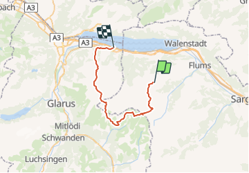
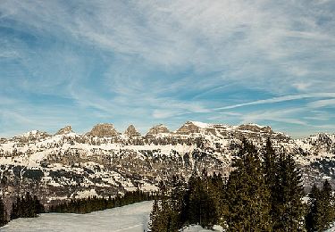
Ruta Otra actividad de 31 km a descubrir en San Galo, Wahlkreis Sarganserland, Quarten. Esta ruta ha sido propuesta por alternatives-wandern.
Descripción
Details siehe Wanderbeschreibung
1. - 3. Tag zusammengefasst.
http://www.alternatives-wandern.ch/touren/alternative/murgsee.htm
Localización
País:
Switzerland
Región :
San Galo
Departamento/provincia :
Wahlkreis Sarganserland
Municipio :
Quarten
Localidad:
Unknown
Salida:(Dec)
Salida:(UTM)
519274 ; 5212959 (32T) N.
Comentarios
Excursiones cerca
![Excursión Senderismo Quarten - Höhenwanderung Maschgenkamm-Murgsee - Photo](https://media.geolcdn.com/t/375/260/ext.jpg?maxdim=2&url=https%3A%2F%2Fstatic1.geolcdn.com%2Fsiteimages%2Fupload%2Ffiles%2F1553511878bg_sport_marche.png)
![Senderismo Senderismo](https://static1.geolcdn.com/sitytour/trail-icons/101.png)
Höhenwanderung Maschgenkamm-Murgsee
Senderismo
Muy fácil
(1)
Quarten,
San Galo,
Wahlkreis Sarganserland,
Switzerland
![](/images/other/stat-length.png)
28 km | 48 km-effort
Desconocido
![](https://static1.geolcdn.com/siteimages/upload/files/16400158638029165_repeat_loop_refresh_sync_direction_icon.png)
No
![Excursión A pie Flums - Bergheim Vadella - Bildbrugg - Photo](https://media.geolcdn.com/t/375/260/a41923a2-5a3b-4b8d-8a8a-9e4f6c4dbf8b.jpeg&format=jpg&maxdim=2)
![A pie A pie](https://static1.geolcdn.com/sitytour/trail-icons/100.png)
Bergheim Vadella - Bildbrugg
A pie
Fácil
Flums,
San Galo,
Wahlkreis Sarganserland,
Switzerland
![](/images/other/stat-length.png)
3,7 km | 4,7 km-effort
1h 4min
![](https://static1.geolcdn.com/siteimages/upload/files/16400158638029165_repeat_loop_refresh_sync_direction_icon.png)
No
![Excursión A pie Flums - 7-Gipfel-Tour - Photo](https://media.geolcdn.com/t/375/260/c2e664f0-e400-4b71-9f4d-996bd72bff79.jpeg&format=jpg&maxdim=2)
![A pie A pie](https://static1.geolcdn.com/sitytour/trail-icons/100.png)
7-Gipfel-Tour
A pie
Fácil
Flums,
San Galo,
Wahlkreis Sarganserland,
Switzerland
![](/images/other/stat-length.png)
9,6 km | 17,5 km-effort
3h 58min
![](https://static1.geolcdn.com/siteimages/upload/files/16400158638029165_repeat_loop_refresh_sync_direction_icon.png)
No
![Excursión A pie Quarten - Oberterzen - Hessenberg - Photo](https://media.geolcdn.com/t/375/260/635ff4d9-89f4-4d2f-8049-7fc584df7199.jpeg&format=jpg&maxdim=2)
![A pie A pie](https://static1.geolcdn.com/sitytour/trail-icons/100.png)
Oberterzen - Hessenberg
A pie
Fácil
Quarten,
San Galo,
Wahlkreis Sarganserland,
Switzerland
![](/images/other/stat-length.png)
3,3 km | 7,7 km-effort
1h 45min
![](https://static1.geolcdn.com/siteimages/upload/files/16400158638029165_repeat_loop_refresh_sync_direction_icon.png)
No
![Excursión A pie Quarten - Oberterzen - Heusee - Photo](https://media.geolcdn.com/t/375/260/9af17ee1-00f1-4340-9b59-dc260aba1df2.jpeg&format=jpg&maxdim=2)
![A pie A pie](https://static1.geolcdn.com/sitytour/trail-icons/100.png)
Oberterzen - Heusee
A pie
Fácil
Quarten,
San Galo,
Wahlkreis Sarganserland,
Switzerland
![](/images/other/stat-length.png)
4,8 km | 14,4 km-effort
3h 15min
![](https://static1.geolcdn.com/siteimages/upload/files/16400158638029165_repeat_loop_refresh_sync_direction_icon.png)
No
![Excursión A pie Quarten - Zigerfurgglen - Heusee - Photo](https://media.geolcdn.com/t/375/260/9af17ee1-00f1-4340-9b59-dc260aba1df2.jpeg&format=jpg&maxdim=2)
![A pie A pie](https://static1.geolcdn.com/sitytour/trail-icons/100.png)
Zigerfurgglen - Heusee
A pie
Fácil
Quarten,
San Galo,
Wahlkreis Sarganserland,
Switzerland
![](/images/other/stat-length.png)
3,3 km | 7,5 km-effort
1h 42min
![](https://static1.geolcdn.com/siteimages/upload/files/16400158638029165_repeat_loop_refresh_sync_direction_icon.png)
No
![Excursión A pie Quarten - Rotenberg - Maschgenkamm - Photo](https://media.geolcdn.com/t/375/260/47ae1c87-f47a-4881-99a5-9c0ff652bf5b.jpeg&format=jpg&maxdim=2)
![A pie A pie](https://static1.geolcdn.com/sitytour/trail-icons/100.png)
Rotenberg - Maschgenkamm
A pie
Fácil
Quarten,
San Galo,
Wahlkreis Sarganserland,
Switzerland
![](/images/other/stat-length.png)
3,8 km | 8,9 km-effort
2h 0min
![](https://static1.geolcdn.com/siteimages/upload/files/16400158638029165_repeat_loop_refresh_sync_direction_icon.png)
No
![Excursión A pie Flums - Tannenboden - Seebenalp - Photo](https://media.geolcdn.com/t/375/260/d8354ac0-c3f6-4655-be47-0074c982ddb5.jpeg&format=jpg&maxdim=2)
![A pie A pie](https://static1.geolcdn.com/sitytour/trail-icons/100.png)
Tannenboden - Seebenalp
A pie
Fácil
Flums,
San Galo,
Wahlkreis Sarganserland,
Switzerland
![](/images/other/stat-length.png)
3,5 km | 6,7 km-effort
1h 31min
![](https://static1.geolcdn.com/siteimages/upload/files/16400158638029165_repeat_loop_refresh_sync_direction_icon.png)
No
![Excursión A pie Quarten - Merlen-Murgseefuggi - Photo](https://media.geolcdn.com/t/375/260/becc44a1-04ca-4aa2-8a47-b66fc9a4ecc8.jpeg&format=jpg&maxdim=2)
![A pie A pie](https://static1.geolcdn.com/sitytour/trail-icons/100.png)
Merlen-Murgseefuggi
A pie
Fácil
Quarten,
San Galo,
Wahlkreis Sarganserland,
Switzerland
![](/images/other/stat-length.png)
7,1 km | 16 km-effort
3h 38min
![](https://static1.geolcdn.com/siteimages/upload/files/16400158638029165_repeat_loop_refresh_sync_direction_icon.png)
No