![](/images/other/stat-length.png)
![Excursión Senderismo Guérande - Les marais salants de Gurérande - Photo](https://media.geolcdn.com/t/1900/400/ext.pjpeg?maxdim=2&url=https%3A%2F%2Fstatic1.geolcdn.com%2Fsiteimages%2Fupload%2Ffiles%2F1553511878bg_sport_marche.png)
Les marais salants de Gurérande
neoroll44
Usuario
![Longitud](/images/other/stat-length.png)
Longitud
14,8 km
![Altitud máxima](https://static1.geolcdn.com/siteimages/upload/files/1508320355ic_sort_altitude_max_24dp.png)
Altitud máxima
26 m
![Desnivel positivo](https://static1.geolcdn.com/siteimages/upload/files/1508320355ic_sort_den_pos_24dp.png)
Desnivel positivo
65 m
![Km-Effort](/images/other/stat-length.png)
Km-Effort
15,6 km
![Altitud mínima](https://static1.geolcdn.com/siteimages/upload/files/1508320355ic_sort_altitude_min_24dp.png)
Altitud mínima
-1 m
![Desnivel negativo](https://static1.geolcdn.com/siteimages/upload/files/1508320355ic_sort_den_neg_24dp.png)
Desnivel negativo
64 m
![Boucle](https://static1.geolcdn.com/siteimages/upload/files/16400158638029165_repeat_loop_refresh_sync_direction_icon.png)
Boucle
Sí
Fecha de creación :
2015-06-29 00:00:00.0
Última modificación :
2015-06-29 00:00:00.0
![Senderismo](https://static1.geolcdn.com/sitytour/trail-icons/101.png)
3h35
Dificultad : Medio
![Escanee este código QR para abrir la excursión en la aplicación SityTrail](https://capi.geolives.com/qq0zvz2zws4bq2lad0pu/sitytour/trails/439526/qr.png?size=200)
Aplicación GPS de excursión GRATIS
A propósito
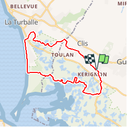
Ruta Senderismo de 14,8 km a descubrir en Países del Loira, Loira-Atlántico, Guérande. Esta ruta ha sido propuesta por neoroll44.
Descripción
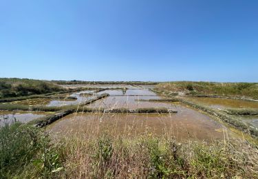
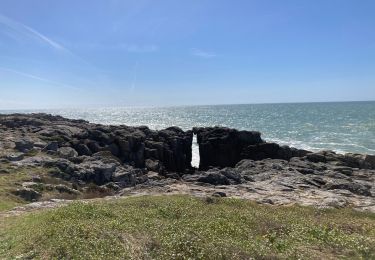
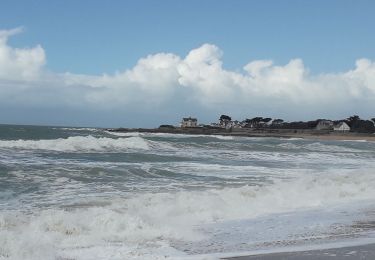
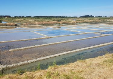
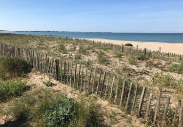
La plage, la forêt de pins, les marais salants, les côteaux de Guérande: un site unique! Respectez les propriétés privées et les oiseaux nichant dans le marais. restez sur les sentiers! Merci.
Localización
País:
France
Región :
Países del Loira
Departamento/provincia :
Loira-Atlántico
Municipio :
Guérande
Localidad:
Unknown
Salida:(Dec)
Salida:(UTM)
541129 ; 5241318 (30T) N.
Comentarios
Excursiones cerca
![Excursión Senderismo Le Croisic - Le Croisic - Photo](https://media.geolcdn.com/t/375/260/ext.jpg?maxdim=2&url=https%3A%2F%2Fservices.sitytrail.com%2FGeolivesWS%2FDownloadMedia.ashx%3FTrailID%3D163795%26Media%3D20121122141355.jpeg)
![Senderismo Senderismo](https://static1.geolcdn.com/sitytour/trail-icons/101.png)
Le Croisic
Senderismo
Fácil
(1)
Le Croisic,
Países del Loira,
Loira-Atlántico,
France
![](/images/other/stat-length.png)
9,8 km | 10,6 km-effort
2h 42min
![](https://static1.geolcdn.com/siteimages/upload/files/16400158638029165_repeat_loop_refresh_sync_direction_icon.png)
Sí
![Excursión Senderismo Guérande - De Guérande à La Turballe par les marais - Photo](https://media.geolcdn.com/t/375/260/ext.jpg?maxdim=2&url=https%3A%2F%2Fstatic1.geolcdn.com%2Fsiteimages%2Fupload%2Ffiles%2F1553511878bg_sport_marche.png)
![Senderismo Senderismo](https://static1.geolcdn.com/sitytour/trail-icons/101.png)
De Guérande à La Turballe par les marais
Senderismo
Difícil
(1)
Guérande,
Países del Loira,
Loira-Atlántico,
France
![](/images/other/stat-length.png)
22 km | 24 km-effort
6h 40min
![](https://static1.geolcdn.com/siteimages/upload/files/16400158638029165_repeat_loop_refresh_sync_direction_icon.png)
Sí
![Excursión Senderismo Le Croisic - croisic - Photo](https://media.geolcdn.com/t/375/260/ext.jpg?maxdim=2&url=https%3A%2F%2Fstatic1.geolcdn.com%2Fsiteimages%2Fupload%2Ffiles%2F1553511878bg_sport_marche.png)
![Senderismo Senderismo](https://static1.geolcdn.com/sitytour/trail-icons/101.png)
croisic
Senderismo
Fácil
(1)
Le Croisic,
Países del Loira,
Loira-Atlántico,
France
![](/images/other/stat-length.png)
11,5 km | 12,3 km-effort
2h 45min
![](https://static1.geolcdn.com/siteimages/upload/files/16400158638029165_repeat_loop_refresh_sync_direction_icon.png)
No
![Excursión Senderismo Batz-sur-Mer - Marais Salants de Batz sur Mer - Photo](https://media.geolcdn.com/t/375/260/0cbedef9-4727-4a02-9453-781bf1178122.jpg&format=jpg&maxdim=2)
![Senderismo Senderismo](https://static1.geolcdn.com/sitytour/trail-icons/101.png)
Marais Salants de Batz sur Mer
Senderismo
Fácil
Batz-sur-Mer,
Países del Loira,
Loira-Atlántico,
France
![](/images/other/stat-length.png)
3,2 km | 3,2 km-effort
43min
![](https://static1.geolcdn.com/siteimages/upload/files/16400158638029165_repeat_loop_refresh_sync_direction_icon.png)
Sí
![Excursión Senderismo Le Croisic - Le Croisic -St Nazaire 1/2 - Photo](https://media.geolcdn.com/t/375/260/1699625e-3873-472f-af6d-4418e90dba3c.jpg&format=jpg&maxdim=2)
![Senderismo Senderismo](https://static1.geolcdn.com/sitytour/trail-icons/101.png)
Le Croisic -St Nazaire 1/2
Senderismo
Medio
Le Croisic,
Países del Loira,
Loira-Atlántico,
France
![](/images/other/stat-length.png)
29 km | 31 km-effort
5h 43min
![](https://static1.geolcdn.com/siteimages/upload/files/16400158638029165_repeat_loop_refresh_sync_direction_icon.png)
No
![Excursión Senderismo Le Croisic - Le Croisic Batz - Photo](https://media.geolcdn.com/t/375/260/2a682bdd-9217-4a48-81de-58891d2fca05.jpg&format=jpg&maxdim=2)
![Senderismo Senderismo](https://static1.geolcdn.com/sitytour/trail-icons/101.png)
Le Croisic Batz
Senderismo
Muy difícil
Le Croisic,
Países del Loira,
Loira-Atlántico,
France
![](/images/other/stat-length.png)
21 km | 22 km-effort
5h 6min
![](https://static1.geolcdn.com/siteimages/upload/files/16400158638029165_repeat_loop_refresh_sync_direction_icon.png)
Sí
![Excursión A pie Le Croisic - Le Tour de Côte - Photo](https://media.geolcdn.com/t/375/260/94d81a2d-adf2-41f1-83b7-caaf1d3c7af0.jpeg&format=jpg&maxdim=2)
![A pie A pie](https://static1.geolcdn.com/sitytour/trail-icons/100.png)
Le Tour de Côte
A pie
Fácil
Le Croisic,
Países del Loira,
Loira-Atlántico,
France
![](/images/other/stat-length.png)
5 km | 5,4 km-effort
1h 13min
![](https://static1.geolcdn.com/siteimages/upload/files/16400158638029165_repeat_loop_refresh_sync_direction_icon.png)
No
![Excursión Senderismo Guérande - Guerande La Turballe et retour - Photo](https://media.geolcdn.com/t/375/260/18c14a3c-15ca-4d7c-a32e-6898f74dab5a.jpg&format=jpg&maxdim=2)
![Senderismo Senderismo](https://static1.geolcdn.com/sitytour/trail-icons/101.png)
Guerande La Turballe et retour
Senderismo
Muy fácil
Guérande,
Países del Loira,
Loira-Atlántico,
France
![](/images/other/stat-length.png)
22 km | 24 km-effort
4h 42min
![](https://static1.geolcdn.com/siteimages/upload/files/16400158638029165_repeat_loop_refresh_sync_direction_icon.png)
Sí
![Excursión Senderismo La Turballe - La Turballe Pen Bron - Photo](https://media.geolcdn.com/t/375/260/eb347f62-ae67-4331-9b20-f94cbabc8a27.jpg&format=jpg&maxdim=2)
![Senderismo Senderismo](https://static1.geolcdn.com/sitytour/trail-icons/101.png)
La Turballe Pen Bron
Senderismo
Fácil
La Turballe,
Países del Loira,
Loira-Atlántico,
France
![](/images/other/stat-length.png)
10,1 km | 10,7 km-effort
2h 46min
![](https://static1.geolcdn.com/siteimages/upload/files/16400158638029165_repeat_loop_refresh_sync_direction_icon.png)
Sí