![](/images/other/stat-length.png)
![Excursión Senderismo La Londe-les-Maures - Valcros - Photo](https://media.geolcdn.com/t/1900/400/6e8bf789-3bce-4b6d-a02e-bc7b394812c5.jpg&format=pjpeg&maxdim=2)
Valcros
FSantoni
Usuario
![Longitud](/images/other/stat-length.png)
![Altitud máxima](https://static1.geolcdn.com/siteimages/upload/files/1508320355ic_sort_altitude_max_24dp.png)
![Desnivel positivo](https://static1.geolcdn.com/siteimages/upload/files/1508320355ic_sort_den_pos_24dp.png)
![Km-Effort](/images/other/stat-length.png)
![Altitud mínima](https://static1.geolcdn.com/siteimages/upload/files/1508320355ic_sort_altitude_min_24dp.png)
![Desnivel negativo](https://static1.geolcdn.com/siteimages/upload/files/1508320355ic_sort_den_neg_24dp.png)
![Boucle](https://static1.geolcdn.com/siteimages/upload/files/16400158638029165_repeat_loop_refresh_sync_direction_icon.png)
![Senderismo](https://static1.geolcdn.com/sitytour/trail-icons/101.png)
6h07
Dificultad : Muy difícil
![Escanee este código QR para abrir la excursión en la aplicación SityTrail](https://capi.geolives.com/qq0zvz2zws4bq2lad0pu/sitytour/trails/4348313/qr.png?size=200)
Aplicación GPS de excursión GRATIS
A propósito
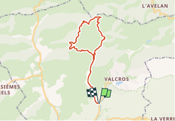
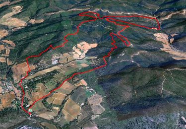
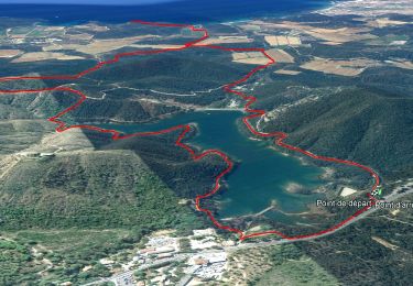
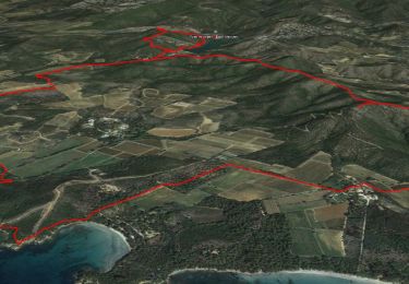
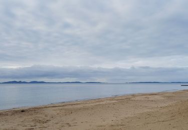
Ruta Senderismo de 16,2 km a descubrir en Provenza-Alpes-Costa Azul, Var, La Londe-les-Maures. Esta ruta ha sido propuesta por FSantoni.
Descripción
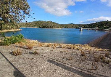
Après les bonnes pluies de ces derniers jours, une promenade sans difficultés mais vraiment trés agréable dans les Maures dans le secteur de Valcros.
Attention, le passage entre les points 9,5 et 12,5 km n'est pas mentionné sur Sity trail alors que ce chemin est en parfait état... Cette application a des lacunes.
Localización
Comentarios
Excursiones cerca
![Excursión Senderismo La Londe-les-Maures - SityTrail - Notre Dame des Maures-12-02-21 - Photo](https://media.geolcdn.com/t/375/260/0b9959c2-5f7c-4a9a-9278-b73c6a0d11e2.jpg&format=jpg&maxdim=2)
![Senderismo Senderismo](https://static1.geolcdn.com/sitytour/trail-icons/101.png)
Senderismo
![](/images/other/stat-length.png)
![](https://static1.geolcdn.com/siteimages/upload/files/16400158638029165_repeat_loop_refresh_sync_direction_icon.png)
![Excursión Senderismo La Londe-les-Maures - la londe des maures- fort de bregancon - Photo](https://media.geolcdn.com/t/375/260/ext.jpg?maxdim=2&url=https%3A%2F%2Fservices.sitytrail.com%2FGeolivesWS%2FDownloadMedia.ashx%3FTrailID%3D174341%26Media%3D20130208144246.jpeg)
![Senderismo Senderismo](https://static1.geolcdn.com/sitytour/trail-icons/101.png)
Senderismo
![](/images/other/stat-length.png)
![](https://static1.geolcdn.com/siteimages/upload/files/16400158638029165_repeat_loop_refresh_sync_direction_icon.png)
![Excursión Senderismo Bormes-les-Mimosas - SityTrail - Barrage du Trapan - Estagnol - Pellegrin - Photo](https://media.geolcdn.com/t/375/260/ebe11e5b-c00f-4172-b479-00c30bf032ed.jpg&format=jpg&maxdim=2)
![Senderismo Senderismo](https://static1.geolcdn.com/sitytour/trail-icons/101.png)
Senderismo
![](/images/other/stat-length.png)
![](https://static1.geolcdn.com/siteimages/upload/files/16400158638029165_repeat_loop_refresh_sync_direction_icon.png)
![Excursión Senderismo Bormes-les-Mimosas - SityTrail - Bormes les Mimosas - Cap Léoube - Photo](https://media.geolcdn.com/t/375/260/313e00c8-6453-4b42-83e0-fd33fc6b49b0.jpg&format=jpg&maxdim=2)
![Senderismo Senderismo](https://static1.geolcdn.com/sitytour/trail-icons/101.png)
Senderismo
![](/images/other/stat-length.png)
![](https://static1.geolcdn.com/siteimages/upload/files/16400158638029165_repeat_loop_refresh_sync_direction_icon.png)
![Excursión Senderismo La Londe-les-Maures - sentier du littoral Lalonde les Maures /Borne les mimosas - Photo](https://media.geolcdn.com/t/375/260/d209c0ef-542c-40b6-8173-c2ec0a0a71bb.jpg&format=jpg&maxdim=2)
![Senderismo Senderismo](https://static1.geolcdn.com/sitytour/trail-icons/101.png)
Senderismo
![](/images/other/stat-length.png)
![](https://static1.geolcdn.com/siteimages/upload/files/16400158638029165_repeat_loop_refresh_sync_direction_icon.png)
![Excursión Senderismo La Londe-les-Maures - dolmen de gautabry - Photo](https://media.geolcdn.com/t/375/260/ext.jpg?maxdim=2&url=https%3A%2F%2Fstatic1.geolcdn.com%2Fsiteimages%2Fupload%2Ffiles%2F1553511878bg_sport_marche.png)
![Senderismo Senderismo](https://static1.geolcdn.com/sitytour/trail-icons/101.png)
Senderismo
![](/images/other/stat-length.png)
![](https://static1.geolcdn.com/siteimages/upload/files/16400158638029165_repeat_loop_refresh_sync_direction_icon.png)
![Excursión Senderismo Bormes-les-Mimosas - Le lac du Trapan - Photo](https://media.geolcdn.com/t/375/260/ext.jpg?maxdim=2&url=https%3A%2F%2Fservices.sitytrail.com%2FGeolivesWS%2FDownloadMedia.ashx%3FTrailID%3D452325%26Media%3D9e2d6742-85b3-4012-991e-d22c6e0c5c2a.jpg)
![Senderismo Senderismo](https://static1.geolcdn.com/sitytour/trail-icons/101.png)
Senderismo
![](/images/other/stat-length.png)
![](https://static1.geolcdn.com/siteimages/upload/files/16400158638029165_repeat_loop_refresh_sync_direction_icon.png)
![Excursión Senderismo La Londe-les-Maures - Plage de L'Argentière ~ Fort de Brégançon - Photo](https://media.geolcdn.com/t/375/260/c46b2534-bf59-4e8a-b909-995c31cd07e2.jpg&format=jpg&maxdim=2)
![Senderismo Senderismo](https://static1.geolcdn.com/sitytour/trail-icons/101.png)
Senderismo
![](/images/other/stat-length.png)
![](https://static1.geolcdn.com/siteimages/upload/files/16400158638029165_repeat_loop_refresh_sync_direction_icon.png)
![Excursión Senderismo Bormes-les-Mimosas - Barrage du Trapan 10-01-2025 - Photo](https://media.geolcdn.com/t/375/260/bbd7ee92-d814-40ba-8b63-839249d00720.jpg&format=jpg&maxdim=2)
![Senderismo Senderismo](https://static1.geolcdn.com/sitytour/trail-icons/101.png)
Senderismo
![](/images/other/stat-length.png)
![](https://static1.geolcdn.com/siteimages/upload/files/16400158638029165_repeat_loop_refresh_sync_direction_icon.png)