


8,2 km | 10,4 km-effort
![Excursión A pie Hromnice - [Z] trojúhelník - Photo](https://media.geolcdn.com/t/1900/400/8244e9d1-3a7b-4319-ab21-6ff4aac17b89.jpeg&format=pjpeg&maxdim=2)

Tous les sentiers balisés d’Europe GUIDE+


Aplicación GPS de excursión GRATIS
 SityTrail
IGN / Institutos geográficos
SityTrail World
El mundo es suyo
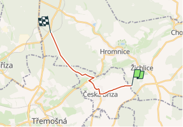
Ruta A pie de 6,1 km a descubrir en Jihozápad, Plzeňský kraj, Hromnice. Esta ruta ha sido propuesta por SityTrail - itinéraires balisés pédestres.
Ruta creada por cz:KČT.
toto není vrcholová cesta, ale místní trasa značená jen trojůhelníkem bez pozadí
![Excursión A pie Hromnice - [Z] trojúhelník - Photo 1](https://media.geolcdn.com/t/2048/auto/521f3003-36b5-4315-8ac8-14c5394f86e1.jpeg&format=jpg&maxdim=0 "Excursión A pie Hromnice - [Z] trojúhelník - Photo 1")
![Excursión A pie Hromnice - [Z] trojúhelník - Photo 2](https://media.geolcdn.com/t/2048/auto/fce5142a-8cf6-4a98-a8d0-84f61d194e60.jpeg&format=jpg&maxdim=0 "Excursión A pie Hromnice - [Z] trojúhelník - Photo 2")
![Excursión A pie Hromnice - [Z] trojúhelník - Photo 3](https://media.geolcdn.com/t/2048/auto/fa9d1b8a-1acc-48b3-ba63-950664d66d59.jpeg&format=jpg&maxdim=0 "Excursión A pie Hromnice - [Z] trojúhelník - Photo 3")
![Excursión A pie Hromnice - [Z] trojúhelník - Photo 4](https://media.geolcdn.com/t/2048/auto/e1ddbcbd-d9d1-4778-a9a3-720f8900c22d.jpeg&format=jpg&maxdim=0 "Excursión A pie Hromnice - [Z] trojúhelník - Photo 4")
![Excursión A pie Hromnice - [Z] trojúhelník - Photo 5](https://media.geolcdn.com/t/2048/auto/9965a7fd-e280-4aa5-b8ad-1bb7803e12a5.jpeg&format=jpg&maxdim=0 "Excursión A pie Hromnice - [Z] trojúhelník - Photo 5")
![Excursión A pie Hromnice - [Z] trojúhelník - Photo 6](https://media.geolcdn.com/t/2048/auto/c7d4219b-1baa-42cf-a5ad-278bfb5a8f89.jpeg&format=jpg&maxdim=0 "Excursión A pie Hromnice - [Z] trojúhelník - Photo 6")
![Excursión A pie Hromnice - [Z] trojúhelník - Photo 7](https://media.geolcdn.com/t/2048/auto/2e970ded-f60c-467f-9ce7-9d5dacf04955.jpeg&format=jpg&maxdim=0 "Excursión A pie Hromnice - [Z] trojúhelník - Photo 7")
![Excursión A pie Hromnice - [Z] trojúhelník - Photo 8](https://media.geolcdn.com/t/2048/auto/677d15c3-bd41-4ddc-a550-6c76a077ae4c.jpeg&format=jpg&maxdim=0 "Excursión A pie Hromnice - [Z] trojúhelník - Photo 8")
![Excursión A pie Hromnice - [Z] trojúhelník - Photo 9](https://media.geolcdn.com/t/2048/auto/eba66c03-2c92-44ce-8884-9e552d54c129.jpeg&format=jpg&maxdim=0 "Excursión A pie Hromnice - [Z] trojúhelník - Photo 9")
![Excursión A pie Hromnice - [Z] trojúhelník - Photo 10](https://media.geolcdn.com/t/2048/auto/8244e9d1-3a7b-4319-ab21-6ff4aac17b89.jpeg&format=jpg&maxdim=0 "Excursión A pie Hromnice - [Z] trojúhelník - Photo 10")
A pie
A pie
![Excursión A pie Zruč-Senec - [M] trojúhelník - Photo](https://media.geolcdn.com/t/375/260/2fd79879-0666-4aef-bdf3-72361d456ac1.jpeg&format=jpg&maxdim=2)
A pie
A pie
A pie
A pie
A pie