![](/images/other/stat-length.png)
![Excursión A pie Unknown - Nacionalni park Paklenica - Photo](https://media.geolcdn.com/t/1900/400/afedae5b-4209-4d66-bdba-6cfba3f997ff.jpeg&format=pjpeg&maxdim=2)
Nacionalni park Paklenica
SityTrail - itinéraires balisés pédestres
Tous les sentiers balisés d’Europe GUIDE+
![Longitud](/images/other/stat-length.png)
![Altitud máxima](https://static1.geolcdn.com/siteimages/upload/files/1508320355ic_sort_altitude_max_24dp.png)
![Desnivel positivo](https://static1.geolcdn.com/siteimages/upload/files/1508320355ic_sort_den_pos_24dp.png)
![Km-Effort](/images/other/stat-length.png)
![Altitud mínima](https://static1.geolcdn.com/siteimages/upload/files/1508320355ic_sort_altitude_min_24dp.png)
![Desnivel negativo](https://static1.geolcdn.com/siteimages/upload/files/1508320355ic_sort_den_neg_24dp.png)
![Boucle](https://static1.geolcdn.com/siteimages/upload/files/16400158638029165_repeat_loop_refresh_sync_direction_icon.png)
![A pie](https://static1.geolcdn.com/sitytour/trail-icons/100.png)
4h46
Dificultad : Medio
![Escanee este código QR para abrir la excursión en la aplicación SityTrail](https://capi.geolives.com/qq0zvz2zws4bq2lad0pu/sitytour/trails/4346147/qr.png?size=200)
Aplicación GPS de excursión GRATIS
A propósito
Ruta A pie de 11,7 km a descubrir en Desconocido, Ličko-senjska županija. Esta ruta ha sido propuesta por SityTrail - itinéraires balisés pédestres.
Descripción
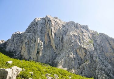
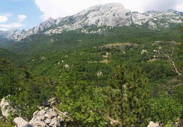
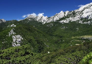
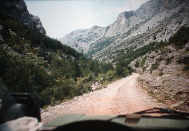
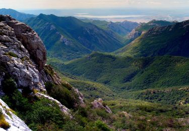
The area of Paklenica is one of the most interesting karst areas of Velebit and Croatia. At the base of the series of the highest peaks of Velebit, torrents have created two deep canyons representing a combination of longitudinal and deeply cut valleys in geomorphological terms. The most ...
Sitio web: https://trail.viadinarica.com/tour/hiking/15966852/
Localización
Comentarios
Excursiones cerca
![Excursión A pie - Bukova staza - Photo](https://media.geolcdn.com/t/375/260/0293162d-3a5f-4b15-b737-440dbc2c1183.jpeg&format=jpg&maxdim=2)
![A pie A pie](https://static1.geolcdn.com/sitytour/trail-icons/100.png)
A pie
![](/images/other/stat-length.png)
![](https://static1.geolcdn.com/siteimages/upload/files/16400158638029165_repeat_loop_refresh_sync_direction_icon.png)
![Excursión A pie - Dom u Velikoj Paklenici - Krajni brig - Photo](https://media.geolcdn.com/t/375/260/9b12ad8e-78b9-402d-9026-622d8b2790f2.jpeg&format=jpg&maxdim=2)
![A pie A pie](https://static1.geolcdn.com/sitytour/trail-icons/100.png)
A pie
![](/images/other/stat-length.png)
![](https://static1.geolcdn.com/siteimages/upload/files/16400158638029165_repeat_loop_refresh_sync_direction_icon.png)
![Excursión A pie - Golić - Stražbenica - Photo](https://media.geolcdn.com/t/375/260/1fb005e9-31bf-41ad-b0c1-91bb8d8fb8c4.jpeg&format=jpg&maxdim=2)
![A pie A pie](https://static1.geolcdn.com/sitytour/trail-icons/100.png)
A pie
![](/images/other/stat-length.png)
![](https://static1.geolcdn.com/siteimages/upload/files/16400158638029165_repeat_loop_refresh_sync_direction_icon.png)
![Excursión A pie - Dom u Velikoj Paklenici - Stražbenica - Photo](https://media.geolcdn.com/t/375/260/74943b82-bfa9-49f1-8ba4-6b0b9dfe9937.jpeg&format=jpg&maxdim=2)
![A pie A pie](https://static1.geolcdn.com/sitytour/trail-icons/100.png)
A pie
![](/images/other/stat-length.png)
![](https://static1.geolcdn.com/siteimages/upload/files/16400158638029165_repeat_loop_refresh_sync_direction_icon.png)
![Excursión A pie - Lipa staza - Photo](https://media.geolcdn.com/t/375/260/cd3917a8-4228-43c8-9d12-c2fc6fd497bd.jpeg&format=jpg&maxdim=2)
![A pie A pie](https://static1.geolcdn.com/sitytour/trail-icons/100.png)
A pie
![](/images/other/stat-length.png)
![](https://static1.geolcdn.com/siteimages/upload/files/16400158638029165_repeat_loop_refresh_sync_direction_icon.png)
![Excursión A pie - Struge - Vaganski vrh - Photo](https://media.geolcdn.com/t/375/260/3896feef-29ff-4652-b14a-a616281106d1.jpeg&format=jpg&maxdim=2)
![A pie A pie](https://static1.geolcdn.com/sitytour/trail-icons/100.png)
A pie
![](/images/other/stat-length.png)
![](https://static1.geolcdn.com/siteimages/upload/files/16400158638029165_repeat_loop_refresh_sync_direction_icon.png)
![Excursión A pie - Vaganski vrh - Sveto Brdo - Photo](https://media.geolcdn.com/t/375/260/afedae5b-4209-4d66-bdba-6cfba3f997ff.jpeg&format=jpg&maxdim=2)
![A pie A pie](https://static1.geolcdn.com/sitytour/trail-icons/100.png)
A pie
![](/images/other/stat-length.png)
![](https://static1.geolcdn.com/siteimages/upload/files/16400158638029165_repeat_loop_refresh_sync_direction_icon.png)
![Excursión A pie - Dom u Velikoj Paklenici - Vlaški grad - Photo](https://media.geolcdn.com/t/375/260/afedae5b-4209-4d66-bdba-6cfba3f997ff.jpeg&format=jpg&maxdim=2)
![A pie A pie](https://static1.geolcdn.com/sitytour/trail-icons/100.png)
A pie
![](/images/other/stat-length.png)
![](https://static1.geolcdn.com/siteimages/upload/files/16400158638029165_repeat_loop_refresh_sync_direction_icon.png)
![Excursión A pie - Dom Paklenica - Jurline - Photo](https://media.geolcdn.com/t/375/260/74943b82-bfa9-49f1-8ba4-6b0b9dfe9937.jpeg&format=jpg&maxdim=2)
![A pie A pie](https://static1.geolcdn.com/sitytour/trail-icons/100.png)
A pie
![](/images/other/stat-length.png)
![](https://static1.geolcdn.com/siteimages/upload/files/16400158638029165_repeat_loop_refresh_sync_direction_icon.png)