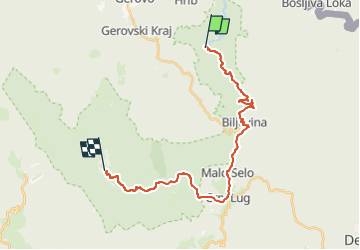
![](/images/other/stat-length.png)
![Excursión A pie Unknown - Nacionalni park Risnjak - Photo](https://media.geolcdn.com/t/1900/400/d7f43ced-7746-4c3c-aa97-9c953327d62b.jpeg&format=pjpeg&maxdim=2)
Nacionalni park Risnjak
SityTrail - itinéraires balisés pédestres
Tous les sentiers balisés d’Europe GUIDE+
![Longitud](/images/other/stat-length.png)
![Altitud máxima](https://static1.geolcdn.com/siteimages/upload/files/1508320355ic_sort_altitude_max_24dp.png)
![Desnivel positivo](https://static1.geolcdn.com/siteimages/upload/files/1508320355ic_sort_den_pos_24dp.png)
![Km-Effort](/images/other/stat-length.png)
![Altitud mínima](https://static1.geolcdn.com/siteimages/upload/files/1508320355ic_sort_altitude_min_24dp.png)
![Desnivel negativo](https://static1.geolcdn.com/siteimages/upload/files/1508320355ic_sort_den_neg_24dp.png)
![Boucle](https://static1.geolcdn.com/siteimages/upload/files/16400158638029165_repeat_loop_refresh_sync_direction_icon.png)
![A pie](https://static1.geolcdn.com/sitytour/trail-icons/100.png)
9h01
Dificultad : Difícil
![Escanee este código QR para abrir la excursión en la aplicación SityTrail](https://capi.geolives.com/qq0zvz2zws4bq2lad0pu/sitytour/trails/4346119/qr.png?size=200)
Aplicación GPS de excursión GRATIS
A propósito
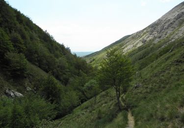
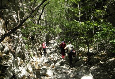
Ruta A pie de 24 km a descubrir en Desconocido, Primorsko-goranska županija. Esta ruta ha sido propuesta por SityTrail - itinéraires balisés pédestres.
Descripción
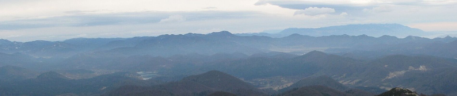
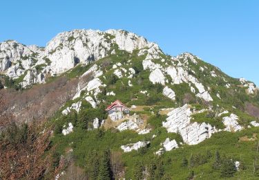
Risnjak has a dominant position at the western end of the region of Gorski kotar, rising from the plateau of Gorski kotar as the final high peak, just before that plateau suddenly starts descending towards the bay of Rijeka in the region of Hrvatsko primorje. The rocky peak area of Risnjak ...
Sitio web: https://trail.viadinarica.com/tour/hiking/15948304/
Localización
Comentarios
Excursiones cerca
![Excursión A pie Loška Dolina - Pot prijateljstva Snežnik-Snježnik - Photo](https://media.geolcdn.com/t/375/260/454ce306-fc2c-43e2-8038-3237620763ce.jpeg&format=jpg&maxdim=2)
![A pie A pie](https://static1.geolcdn.com/sitytour/trail-icons/100.png)
A pie
![](/images/other/stat-length.png)
![](https://static1.geolcdn.com/siteimages/upload/files/16400158638029165_repeat_loop_refresh_sync_direction_icon.png)
![Excursión A pie - Gornje Jelenje - Vilje - Risnjak - Photo](https://media.geolcdn.com/t/375/260/3a1889fd-b233-412c-8ef2-908620f565dc.jpeg&format=jpg&maxdim=2)
![A pie A pie](https://static1.geolcdn.com/sitytour/trail-icons/100.png)
A pie
![](/images/other/stat-length.png)
![](https://static1.geolcdn.com/siteimages/upload/files/16400158638029165_repeat_loop_refresh_sync_direction_icon.png)
![Excursión A pie - Ravno Podolje - Medvjeđa vrata - Photo](https://media.geolcdn.com/t/375/260/5f48b32b-f71e-48e9-b8cd-4e462442dbc6.jpeg&format=jpg&maxdim=2)
![A pie A pie](https://static1.geolcdn.com/sitytour/trail-icons/100.png)
A pie
![](/images/other/stat-length.png)
![](https://static1.geolcdn.com/siteimages/upload/files/16400158638029165_repeat_loop_refresh_sync_direction_icon.png)
![Excursión A pie - Lepenica - Medvjeđa vrata - Risnjak - Photo](https://media.geolcdn.com/t/375/260/3a1889fd-b233-412c-8ef2-908620f565dc.jpeg&format=jpg&maxdim=2)
![A pie A pie](https://static1.geolcdn.com/sitytour/trail-icons/100.png)
A pie
![](/images/other/stat-length.png)
![](https://static1.geolcdn.com/siteimages/upload/files/16400158638029165_repeat_loop_refresh_sync_direction_icon.png)
![Excursión A pie - Gornje Jelenje - Fužine - Photo](https://media.geolcdn.com/t/375/260/bc446bdd-3cfe-45c0-94f3-3ba2d4e990b4.jpeg&format=jpg&maxdim=2)
![A pie A pie](https://static1.geolcdn.com/sitytour/trail-icons/100.png)
A pie
![](/images/other/stat-length.png)
![](https://static1.geolcdn.com/siteimages/upload/files/16400158638029165_repeat_loop_refresh_sync_direction_icon.png)
![Excursión A pie - Tršće - Sveta gora - Izvor Kupe - Crni Lug - Photo](https://media.geolcdn.com/t/375/260/60013492-baa6-4369-bcba-b910bef47edc.jpeg&format=jpg&maxdim=2)
![A pie A pie](https://static1.geolcdn.com/sitytour/trail-icons/100.png)
A pie
![](/images/other/stat-length.png)
![](https://static1.geolcdn.com/siteimages/upload/files/16400158638029165_repeat_loop_refresh_sync_direction_icon.png)
![Excursión A pie - Prezid - Čabar - Tršće - Photo](https://media.geolcdn.com/t/375/260/63396e8a-0219-4975-8a92-2dc12ba77793.jpeg&format=jpg&maxdim=2)
![A pie A pie](https://static1.geolcdn.com/sitytour/trail-icons/100.png)
A pie
![](/images/other/stat-length.png)
![](https://static1.geolcdn.com/siteimages/upload/files/16400158638029165_repeat_loop_refresh_sync_direction_icon.png)
![Excursión A pie - OH 15 - Photo](https://media.geolcdn.com/t/375/260/9b4194d2-19d6-4583-806e-0f711ce103ee.jpeg&format=jpg&maxdim=2)
![A pie A pie](https://static1.geolcdn.com/sitytour/trail-icons/100.png)
A pie
![](/images/other/stat-length.png)
![](https://static1.geolcdn.com/siteimages/upload/files/16400158638029165_repeat_loop_refresh_sync_direction_icon.png)
![Excursión A pie - Potkilvac - Zapodi-Halić - Photo](https://media.geolcdn.com/t/375/260/d3d063af-e7e5-4024-b9b5-6f97f93004ac.jpeg&format=jpg&maxdim=2)
![A pie A pie](https://static1.geolcdn.com/sitytour/trail-icons/100.png)
A pie
![](/images/other/stat-length.png)
![](https://static1.geolcdn.com/siteimages/upload/files/16400158638029165_repeat_loop_refresh_sync_direction_icon.png)