![](/images/other/stat-length.png)
![Excursión A pie Unknown - Zečak - Slap Brisalo - Photo](https://media.geolcdn.com/t/1900/400/ext.pjpeg?maxdim=2&url=https%3A%2F%2Fstatic1.geolcdn.com%2Fsiteimages%2Fupload%2Ffiles%2F1545311037marcheuse_200dpi.jpg)
Zečak - Slap Brisalo
SityTrail - itinéraires balisés pédestres
Tous les sentiers balisés d’Europe GUIDE+
![Longitud](/images/other/stat-length.png)
![Altitud máxima](https://static1.geolcdn.com/siteimages/upload/files/1508320355ic_sort_altitude_max_24dp.png)
![Desnivel positivo](https://static1.geolcdn.com/siteimages/upload/files/1508320355ic_sort_den_pos_24dp.png)
![Km-Effort](/images/other/stat-length.png)
![Altitud mínima](https://static1.geolcdn.com/siteimages/upload/files/1508320355ic_sort_altitude_min_24dp.png)
![Desnivel negativo](https://static1.geolcdn.com/siteimages/upload/files/1508320355ic_sort_den_neg_24dp.png)
![Boucle](https://static1.geolcdn.com/siteimages/upload/files/16400158638029165_repeat_loop_refresh_sync_direction_icon.png)
![A pie](https://static1.geolcdn.com/sitytour/trail-icons/100.png)
1h43
Dificultad : Fácil
![Escanee este código QR para abrir la excursión en la aplicación SityTrail](https://capi.geolives.com/qq0zvz2zws4bq2lad0pu/sitytour/trails/4344941/qr.png?size=200)
Aplicación GPS de excursión GRATIS
A propósito
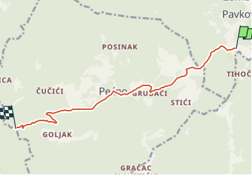
Ruta A pie de 5,7 km a descubrir en Desconocido, Condado de Zagreb. Esta ruta ha sido propuesta por SityTrail - itinéraires balisés pédestres.
Descripción
Ruta creada por HPD Jastrebarsko, Jastrebarsko.
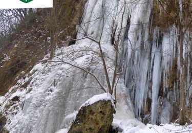
(X) ispod slapa Brisalo u dolini Slapnice(mostić) - slap Brisalo - Zidane pećine - Staničići Žumberački - Pećno - Višoševići (X) s putom iz Tihočaja - vrh Zečak
Localización
Comentarios
Excursiones cerca
![Excursión A pie - Grdanjci - Noršić selo - Photo](https://media.geolcdn.com/t/375/260/360e921b-97d3-4b67-9f69-dac3c02b0938.jpeg&format=jpg&maxdim=2)
![A pie A pie](https://static1.geolcdn.com/sitytour/trail-icons/100.png)
A pie
![](/images/other/stat-length.png)
![](https://static1.geolcdn.com/siteimages/upload/files/16400158638029165_repeat_loop_refresh_sync_direction_icon.png)
![Excursión A pie - Noršić Selo - Katin krč - Photo](https://media.geolcdn.com/t/375/260/b167355c-57af-49c1-ae87-931613543d0f.jpeg&format=jpg&maxdim=2)
![A pie A pie](https://static1.geolcdn.com/sitytour/trail-icons/100.png)
A pie
![](/images/other/stat-length.png)
![](https://static1.geolcdn.com/siteimages/upload/files/16400158638029165_repeat_loop_refresh_sync_direction_icon.png)
![Excursión A pie - Slani dol - Noršić Selo - Photo](https://media.geolcdn.com/t/375/260/360e921b-97d3-4b67-9f69-dac3c02b0938.jpeg&format=jpg&maxdim=2)
![A pie A pie](https://static1.geolcdn.com/sitytour/trail-icons/100.png)
A pie
![](/images/other/stat-length.png)
![](https://static1.geolcdn.com/siteimages/upload/files/16400158638029165_repeat_loop_refresh_sync_direction_icon.png)
![Excursión A pie - Slani dol - Gostinjac Sv. Bernard - Photo](https://media.geolcdn.com/t/375/260/c97b8dc0-0e3a-4e26-bef6-8556ac70acf5.jpeg&format=jpg&maxdim=2)
![A pie A pie](https://static1.geolcdn.com/sitytour/trail-icons/100.png)
A pie
![](/images/other/stat-length.png)
![](https://static1.geolcdn.com/siteimages/upload/files/16400158638029165_repeat_loop_refresh_sync_direction_icon.png)
![Excursión A pie - Šoićeva kuća - Japetić - Photo](https://media.geolcdn.com/t/375/260/b167355c-57af-49c1-ae87-931613543d0f.jpeg&format=jpg&maxdim=2)
![A pie A pie](https://static1.geolcdn.com/sitytour/trail-icons/100.png)
A pie
![](/images/other/stat-length.png)
![](https://static1.geolcdn.com/siteimages/upload/files/16400158638029165_repeat_loop_refresh_sync_direction_icon.png)
![Excursión A pie - Draga - Žitnica - Photo](https://media.geolcdn.com/t/375/260/c97b8dc0-0e3a-4e26-bef6-8556ac70acf5.jpeg&format=jpg&maxdim=2)
![A pie A pie](https://static1.geolcdn.com/sitytour/trail-icons/100.png)
A pie
![](/images/other/stat-length.png)
![](https://static1.geolcdn.com/siteimages/upload/files/16400158638029165_repeat_loop_refresh_sync_direction_icon.png)
![Excursión A pie - Vranjački Slap - Tihočaj - Photo](https://media.geolcdn.com/t/375/260/38d62b06-f0c7-47dd-bba8-e9faa0c1b63c.jpeg&format=jpg&maxdim=2)
![A pie A pie](https://static1.geolcdn.com/sitytour/trail-icons/100.png)
A pie
![](/images/other/stat-length.png)
![](https://static1.geolcdn.com/siteimages/upload/files/16400158638029165_repeat_loop_refresh_sync_direction_icon.png)
![Excursión A pie - Koretići - Gornja Vas - Photo](https://media.geolcdn.com/t/375/260/ee1b2247-18e5-488b-8e88-33333aefa699.jpeg&format=jpg&maxdim=2)
![A pie A pie](https://static1.geolcdn.com/sitytour/trail-icons/100.png)
A pie
![](/images/other/stat-length.png)
![](https://static1.geolcdn.com/siteimages/upload/files/16400158638029165_repeat_loop_refresh_sync_direction_icon.png)
![Excursión A pie - Dragonoš - Zečak - Photo](https://media.geolcdn.com/t/375/260/c97b8dc0-0e3a-4e26-bef6-8556ac70acf5.jpeg&format=jpg&maxdim=2)
![A pie A pie](https://static1.geolcdn.com/sitytour/trail-icons/100.png)
A pie
![](/images/other/stat-length.png)
![](https://static1.geolcdn.com/siteimages/upload/files/16400158638029165_repeat_loop_refresh_sync_direction_icon.png)