![](/images/other/stat-length.png)
![Excursión A pie Klingenthal - Rundwanderweg Klingenthal-Zwota - Photo](https://media.geolcdn.com/t/1900/400/44898a16-7c35-42f5-8612-f02ae3081798.jpeg&format=pjpeg&maxdim=2)
Rundwanderweg Klingenthal-Zwota
SityTrail - itinéraires balisés pédestres
Tous les sentiers balisés d’Europe GUIDE+
![Longitud](/images/other/stat-length.png)
![Altitud máxima](https://static1.geolcdn.com/siteimages/upload/files/1508320355ic_sort_altitude_max_24dp.png)
![Desnivel positivo](https://static1.geolcdn.com/siteimages/upload/files/1508320355ic_sort_den_pos_24dp.png)
![Km-Effort](/images/other/stat-length.png)
![Altitud mínima](https://static1.geolcdn.com/siteimages/upload/files/1508320355ic_sort_altitude_min_24dp.png)
![Desnivel negativo](https://static1.geolcdn.com/siteimages/upload/files/1508320355ic_sort_den_neg_24dp.png)
![Boucle](https://static1.geolcdn.com/siteimages/upload/files/16400158638029165_repeat_loop_refresh_sync_direction_icon.png)
![A pie](https://static1.geolcdn.com/sitytour/trail-icons/100.png)
15h22
Dificultad : Muy difícil
![Escanee este código QR para abrir la excursión en la aplicación SityTrail](https://capi.geolives.com/qq0zvz2zws4bq2lad0pu/sitytour/trails/4344076/qr.png?size=200)
Aplicación GPS de excursión GRATIS
A propósito
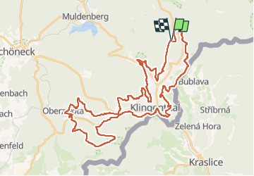
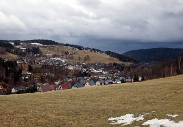
Ruta A pie de 47 km a descubrir en Sajonia, Vogtlandkreis, Klingenthal. Esta ruta ha sido propuesta por SityTrail - itinéraires balisés pédestres.
Descripción
Juni 2013: im Abschnitt Klingenthal, ca. Kammweg 9, ist grüner Strich auf weißem Grund entlang des Grenzpfades ausgeschildert. Im gegensatz dazu befindet such an der Schutzhütte N50 22 29.7 E12 29 18.8 aber auch ein solches Wanderzeichen.
Símbolo: grüner Strich, weißem Grund
Localización
Comentarios
Excursiones cerca
![Excursión A pie Kraslice - [Z] Hraničná (CZ/D) - Kraslice - Photo](https://media.geolcdn.com/t/375/260/9a2c3207-a793-4795-9d2f-4ccb6b0dd654.jpeg&format=jpg&maxdim=2)
![A pie A pie](https://static1.geolcdn.com/sitytour/trail-icons/100.png)
A pie
![](/images/other/stat-length.png)
![](https://static1.geolcdn.com/siteimages/upload/files/16400158638029165_repeat_loop_refresh_sync_direction_icon.png)
![Excursión A pie Muldenhammer - Waldgebiet-Rundweg - Photo](https://media.geolcdn.com/t/375/260/9ecd7729-0093-40c0-8312-cefc7ab9e7fd.jpeg&format=jpg&maxdim=2)
![A pie A pie](https://static1.geolcdn.com/sitytour/trail-icons/100.png)
A pie
![](/images/other/stat-length.png)
![](https://static1.geolcdn.com/siteimages/upload/files/16400158638029165_repeat_loop_refresh_sync_direction_icon.png)
![Excursión A pie Muldenhammer - Pyratalweg - Photo](https://media.geolcdn.com/t/375/260/d3568337-9dbb-4823-8481-c776dcae81f4.jpeg&format=jpg&maxdim=2)
![A pie A pie](https://static1.geolcdn.com/sitytour/trail-icons/100.png)
A pie
![](/images/other/stat-length.png)
![](https://static1.geolcdn.com/siteimages/upload/files/16400158638029165_repeat_loop_refresh_sync_direction_icon.png)
![Excursión A pie Klingenthal - gelbe Markierung - Photo](https://media.geolcdn.com/t/375/260/441bebc5-6103-43f1-8d92-3850cf14ea71.jpeg&format=jpg&maxdim=2)
![A pie A pie](https://static1.geolcdn.com/sitytour/trail-icons/100.png)
A pie
![](/images/other/stat-length.png)
![](https://static1.geolcdn.com/siteimages/upload/files/16400158638029165_repeat_loop_refresh_sync_direction_icon.png)
![Excursión A pie Bublava - [NS] Stopami horníků - Photo](https://media.geolcdn.com/t/375/260/257fa595-2ef7-4f16-a7bf-1d9572e0230e.jpeg&format=jpg&maxdim=2)
![A pie A pie](https://static1.geolcdn.com/sitytour/trail-icons/100.png)
A pie
![](/images/other/stat-length.png)
![](https://static1.geolcdn.com/siteimages/upload/files/16400158638029165_repeat_loop_refresh_sync_direction_icon.png)
![Excursión A pie Muldenhammer - Ww Morgenröthe - Drei Bächel - Photo](https://media.geolcdn.com/t/375/260/ext.jpg?maxdim=2&url=https%3A%2F%2Fstatic1.geolcdn.com%2Fsiteimages%2Fupload%2Ffiles%2F1545311037marcheuse_200dpi.jpg)
![A pie A pie](https://static1.geolcdn.com/sitytour/trail-icons/100.png)
A pie
![](/images/other/stat-length.png)
![](https://static1.geolcdn.com/siteimages/upload/files/16400158638029165_repeat_loop_refresh_sync_direction_icon.png)
![Excursión A pie Klingenthal - gelbe Markierung - Photo](https://media.geolcdn.com/t/375/260/ext.jpg?maxdim=2&url=https%3A%2F%2Fstatic1.geolcdn.com%2Fsiteimages%2Fupload%2Ffiles%2F1545311037marcheuse_200dpi.jpg)
![A pie A pie](https://static1.geolcdn.com/sitytour/trail-icons/100.png)
A pie
![](/images/other/stat-length.png)
![](https://static1.geolcdn.com/siteimages/upload/files/16400158638029165_repeat_loop_refresh_sync_direction_icon.png)