![](/images/other/stat-length.png)
![Excursión A pie Westport-Belmullet Municipal District - Slí Tóin a' tSeanbhaile / Valley Loop Walk - Photo](https://media.geolcdn.com/t/1900/400/677f1f71-59af-4264-8e32-5db8b94c8a4d.jpeg&format=pjpeg&maxdim=2)
Slí Tóin a' tSeanbhaile / Valley Loop Walk
SityTrail - itinéraires balisés pédestres
Tous les sentiers balisés d’Europe GUIDE+
![Longitud](/images/other/stat-length.png)
Longitud
7,3 km
![Altitud máxima](https://static1.geolcdn.com/siteimages/upload/files/1508320355ic_sort_altitude_max_24dp.png)
Altitud máxima
16 m
![Desnivel positivo](https://static1.geolcdn.com/siteimages/upload/files/1508320355ic_sort_den_pos_24dp.png)
Desnivel positivo
42 m
![Km-Effort](/images/other/stat-length.png)
Km-Effort
7,8 km
![Altitud mínima](https://static1.geolcdn.com/siteimages/upload/files/1508320355ic_sort_altitude_min_24dp.png)
Altitud mínima
1 m
![Desnivel negativo](https://static1.geolcdn.com/siteimages/upload/files/1508320355ic_sort_den_neg_24dp.png)
Desnivel negativo
37 m
![Boucle](https://static1.geolcdn.com/siteimages/upload/files/16400158638029165_repeat_loop_refresh_sync_direction_icon.png)
Boucle
No
Baliza
Fecha de creación :
2025-02-06 13:12:01.683
Última modificación :
2025-02-06 13:12:01.683
![A pie](https://static1.geolcdn.com/sitytour/trail-icons/100.png)
1h46
Dificultad : Fácil
![Escanee este código QR para abrir la excursión en la aplicación SityTrail](https://capi.geolives.com/qq0zvz2zws4bq2lad0pu/sitytour/trails/4342961/qr.png?size=200)
Aplicación GPS de excursión GRATIS
A propósito
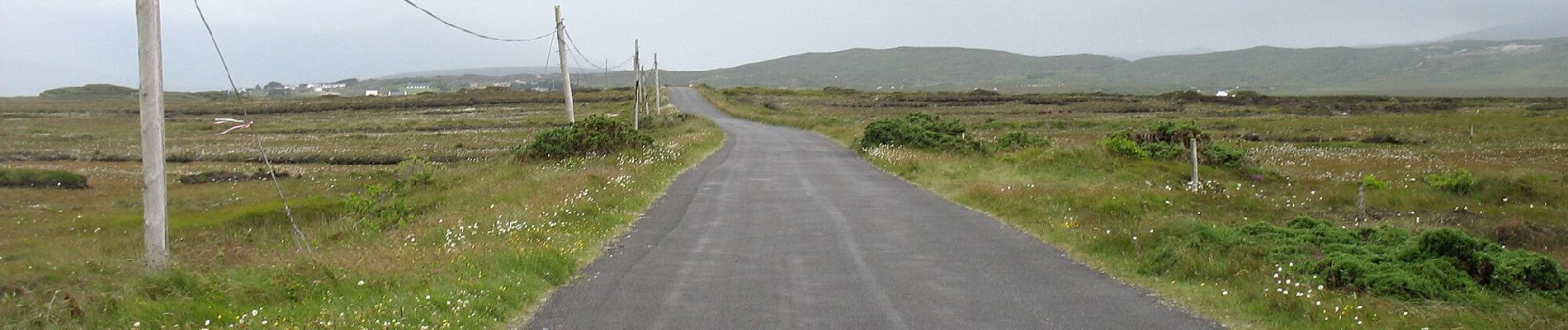
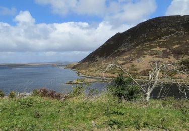
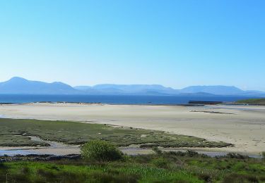
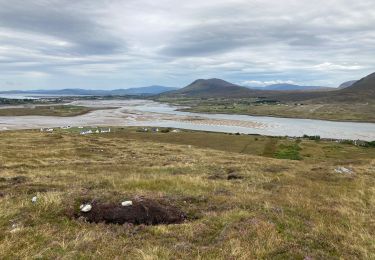
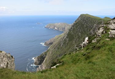
Ruta A pie de 7,3 km a descubrir en Desconocido, County Mayo, Westport-Belmullet Municipal District. Esta ruta ha sido propuesta por SityTrail - itinéraires balisés pédestres.
Descripción
Sitio web: https://achilltourism.com/valley-loop-walk-sli-toin-a-tseanbhaile/
Localización
País:
Ireland
Región :
Desconocido
Departamento/provincia :
County Mayo
Municipio :
Westport-Belmullet Municipal District
Localidad:
Slievemore ED
Salida:(Dec)
Salida:(UTM)
434780 ; 5985347 (29U) N.
Comentarios
Excursiones cerca
![Excursión A pie Westport-Belmullet Municipal District - Causeway Loop Walk - Photo](https://media.geolcdn.com/t/375/260/1c76fb76-10fa-4a2e-9183-8a80e5bcbc5c.jpeg&format=jpg&maxdim=2)
![A pie A pie](https://static1.geolcdn.com/sitytour/trail-icons/100.png)
Causeway Loop Walk
A pie
Fácil
Westport-Belmullet Municipal District,
Desconocido,
County Mayo,
Ireland
![](/images/other/stat-length.png)
4,8 km | 6 km-effort
1h 22min
![](https://static1.geolcdn.com/siteimages/upload/files/16400158638029165_repeat_loop_refresh_sync_direction_icon.png)
No
![Excursión A pie Westport-Belmullet Municipal District - Lookout Hill Loop Walk - Photo](https://media.geolcdn.com/t/375/260/bb48f8ac-ba9d-4302-b827-301974dc309f.jpeg&format=jpg&maxdim=2)
![A pie A pie](https://static1.geolcdn.com/sitytour/trail-icons/100.png)
Lookout Hill Loop Walk
A pie
Fácil
Westport-Belmullet Municipal District,
Desconocido,
County Mayo,
Ireland
![](/images/other/stat-length.png)
6,2 km | 8,3 km-effort
1h 53min
![](https://static1.geolcdn.com/siteimages/upload/files/16400158638029165_repeat_loop_refresh_sync_direction_icon.png)
No
![Excursión A pie Westport-Belmullet Municipal District - The Saula Loop - Photo](https://media.geolcdn.com/t/375/260/81e833e1-838c-45c6-a4a1-fcfb7cd4e36b.jpeg&format=jpg&maxdim=2)
![A pie A pie](https://static1.geolcdn.com/sitytour/trail-icons/100.png)
The Saula Loop
A pie
Fácil
Westport-Belmullet Municipal District,
Desconocido,
County Mayo,
Ireland
![](/images/other/stat-length.png)
8,8 km | 10,8 km-effort
2h 27min
![](https://static1.geolcdn.com/siteimages/upload/files/16400158638029165_repeat_loop_refresh_sync_direction_icon.png)
No
![Excursión Senderismo Westport-Belmullet Municipal District - Granuaile loop - Photo](https://media.geolcdn.com/t/375/260/913f46e2-b5f9-408a-95cb-57e60b2d2dd9.jpg&format=jpg&maxdim=2)
![Senderismo Senderismo](https://static1.geolcdn.com/sitytour/trail-icons/101.png)
Granuaile loop
Senderismo
Medio
Westport-Belmullet Municipal District,
Desconocido,
County Mayo,
Ireland
![](/images/other/stat-length.png)
6,9 km | 10,1 km-effort
2h 9min
![](https://static1.geolcdn.com/siteimages/upload/files/16400158638029165_repeat_loop_refresh_sync_direction_icon.png)
Sí
![Senderismo Senderismo](https://static1.geolcdn.com/sitytour/trail-icons/101.png)
Mon parcours
Senderismo
Medio
Westport-Belmullet Municipal District,
Desconocido,
County Mayo,
Ireland
![](/images/other/stat-length.png)
7,2 km | 13,5 km-effort
2h 38min
![](https://static1.geolcdn.com/siteimages/upload/files/16400158638029165_repeat_loop_refresh_sync_direction_icon.png)
Sí
![Excursión Senderismo Westport-Belmullet Municipal District - Falaise de Keem - Photo](https://media.geolcdn.com/t/375/260/ext.jpg?maxdim=2&url=https%3A%2F%2Fstatic1.geolcdn.com%2Fsiteimages%2Fupload%2Ffiles%2F1553511878bg_sport_marche.png)
![Senderismo Senderismo](https://static1.geolcdn.com/sitytour/trail-icons/101.png)
Falaise de Keem
Senderismo
Fácil
Westport-Belmullet Municipal District,
Desconocido,
County Mayo,
Ireland
![](/images/other/stat-length.png)
5,9 km | 11,6 km-effort
3h 0min
![](https://static1.geolcdn.com/siteimages/upload/files/16400158638029165_repeat_loop_refresh_sync_direction_icon.png)
Sí
![Excursión Bici de montaña Westport-Belmullet Municipal District - Achill Island Loop 2 - Photo](https://media.geolcdn.com/t/375/260/ext.jpg?maxdim=2&url=https%3A%2F%2Fstatic1.geolcdn.com%2Fsiteimages%2Fupload%2Ffiles%2F1524743154velo.jpg)
![Bici de montaña Bici de montaña](https://static1.geolcdn.com/sitytour/trail-icons/202.png)
Achill Island Loop 2
Bici de montaña
Difícil
Westport-Belmullet Municipal District,
Desconocido,
County Mayo,
Ireland
![](/images/other/stat-length.png)
27 km | 31 km-effort
2h 9min
![](https://static1.geolcdn.com/siteimages/upload/files/16400158638029165_repeat_loop_refresh_sync_direction_icon.png)
Sí
![Excursión Coche Westport-Belmullet Municipal District - Achill Island - Easkey WAW part 9 - Photo](https://media.geolcdn.com/t/375/260/ext.jpg?maxdim=2&url=https%3A%2F%2Fstatic1.geolcdn.com%2Fsiteimages%2Fupload%2Ffiles%2F15247431544x4.jpg)
![Coche Coche](https://static1.geolcdn.com/sitytour/trail-icons/401.png)
Achill Island - Easkey WAW part 9
Coche
Muy fácil
Westport-Belmullet Municipal District,
Desconocido,
County Mayo,
Ireland
![](/images/other/stat-length.png)
363 km | 404 km-effort
Desconocido
![](https://static1.geolcdn.com/siteimages/upload/files/16400158638029165_repeat_loop_refresh_sync_direction_icon.png)
No
![Excursión Senderismo Westport-Belmullet Municipal District - Achill Croaghaun - Photo](https://media.geolcdn.com/t/375/260/ext.jpg?maxdim=2&url=https%3A%2F%2Fstatic1.geolcdn.com%2Fsiteimages%2Fupload%2Ffiles%2F1553511878bg_sport_marche.png)
![Senderismo Senderismo](https://static1.geolcdn.com/sitytour/trail-icons/101.png)
Achill Croaghaun
Senderismo
Muy fácil
Westport-Belmullet Municipal District,
Desconocido,
County Mayo,
Ireland
![](/images/other/stat-length.png)
12,2 km | 26 km-effort
5h 23min
![](https://static1.geolcdn.com/siteimages/upload/files/16400158638029165_repeat_loop_refresh_sync_direction_icon.png)
Sí