Excursión A pie The Municipal District of Arklow - Avonmore Way - Photo

Tous les sentiers balisés d’Europe GUIDE+

© OpenStreetMap contributors
Longitud
Longitud
12,9 km
Altitud máxima
Altitud máxima
274 m
Desnivel positivo
Desnivel positivo
314 m
Km-Effort
Km-Effort  
17 km
Altitud mínima
Altitud mínima
85 m
Desnivel negativo
Desnivel negativo
278 m
Boucle
Boucle
No
Baliza
Baliza
Fecha de creación :
2025-02-06 12:55:50.835
Última modificación :
2025-02-06 12:55:50.835

(0 Opinión)

A pie
A pie
3h51
Dificultad : Fácil

Escanee este código QR para abrir la excursión en la aplicación SityTrail

Aplicación GPS de excursión GRATIS

Logo SityTrail SityTrail

IGN / Institutos geográficos

Descargar SityTrail en App Store Descargar SityTrail en Google Play

Logo SityTrail SityTrail World

El mundo es suyo

Descargar SityTrail en App Store Descargar SityTrail en Google Play Descargar SityTrail en Huawei AppGallery

A propósito

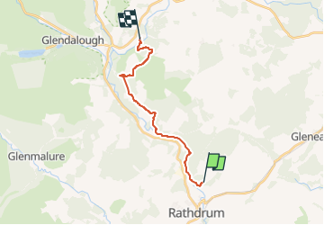
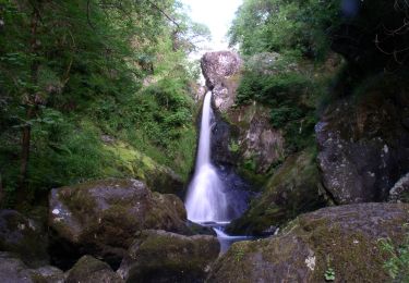
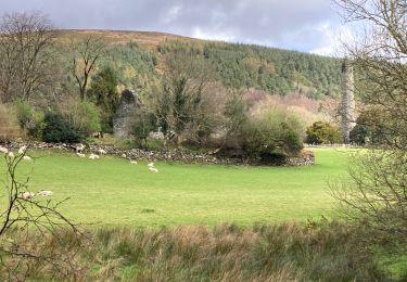
Ruta A pie de 12,9 km a descubrir en Desconocido, County Wicklow, The Municipal District of Arklow. Esta ruta ha sido propuesta por SityTrail - itinéraires balisés pédestres.

Descripción

Ruta creada por Wicklow Uplands Council.

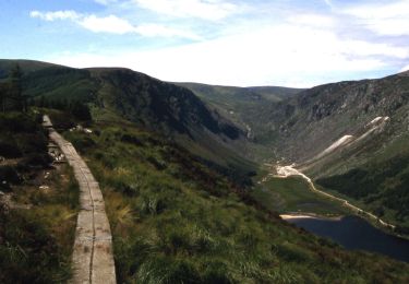
Símbolo: yellow hiker on black


Sitio web: http://www.irishtrails.ie/Trail/Avonmore-Way/905/

Perfil altimétrico

Fotos

Localización

País:
Ireland
Región :
Desconocido
Departamento/provincia :
County Wicklow
Municipio :
The Municipal District of Arklow
Localidad:
Rathdrum
Salida:(UTM)
686383 ; 5869817 (29U) N.

Excursiones cerca

Excursión A pie The Municipal District of Wicklow - Spinc and Glenealo Valley - Photo
A pie
GUIDE+

A pie

Fácil
The Municipal District of Wicklow, Desconocido, County Wicklow, Ireland
9,2 km | 14,6 km-effort
3h 19min
Excursión A pie The Municipal District of Wicklow - Slí na Sláinte - Photo
A pie
GUIDE+

A pie

Fácil
The Municipal District of Wicklow, Desconocido, County Wicklow, Ireland
7,1 km | 7,8 km-effort
1h 46min
Excursión A pie The Municipal District of Wicklow - Saint Kevin's Way - Photo
A pie
GUIDE+

A pie

Fácil
The Municipal District of Wicklow, Desconocido, County Wicklow, Ireland
6,6 km | 10,2 km-effort
2h 19min
No
Excursión A pie The Municipal District of Wicklow - Waterfall Walk - Photo
A pie
GUIDE+

A pie

Fácil
The Municipal District of Wicklow, Desconocido, County Wicklow, Ireland
4,8 km | 6,7 km-effort
1h 32min
No
Excursión Senderismo The Municipal District of Wicklow - Glendalough  - Photo
Senderismo
Lobin

Senderismo

Medio
The Municipal District of Wicklow, Desconocido, County Wicklow, Ireland
9,4 km | 13,7 km-effort
2h 21min
Excursión Senderismo The Municipal District of Wicklow - Glendalough - Photo
Senderismo
FabienneD

Senderismo

Medio
The Municipal District of Wicklow, Desconocido, County Wicklow, Ireland
9,6 km | 14 km-effort
2h 59min
Excursión Otra actividad The Municipal District of Wicklow - Willie Whelan - Photo
Otra actividad
adagio

Otra actividad

Muy fácil
The Municipal District of Wicklow, Desconocido, County Wicklow, Ireland
9,4 km | 15,3 km-effort
Desconocido
Excursión Senderismo The Municipal District of Wicklow - Mountain Hike from Glendalough car park - Photo
Senderismo
RVCrazy

Senderismo

Muy fácil
The Municipal District of Wicklow, Desconocido, County Wicklow, Ireland
17,2 km | 26 km-effort
6h 1min
Excursión Senderismo The Municipal District of Wicklow - Knocknacloghoge and Fancy Mtn - Photo
Senderismo
jaf299

Senderismo

Muy fácil
The Municipal District of Wicklow, Desconocido, County Wicklow, Ireland
13,1 km | 22 km-effort
Desconocido


Cerrar
Mis suscripciones