![](/images/other/stat-length.png)
![Excursión A pie Unknown - Bath Skyline - Photo](https://media.geolcdn.com/t/1900/400/f1af91b8-6763-482f-996c-c637d22deac6.jpeg&format=pjpeg&maxdim=2)
Bath Skyline
SityTrail - itinéraires balisés pédestres
Tous les sentiers balisés d’Europe GUIDE+
![Longitud](/images/other/stat-length.png)
Longitud
9,3 km
![Altitud máxima](https://static1.geolcdn.com/siteimages/upload/files/1508320355ic_sort_altitude_max_24dp.png)
Altitud máxima
191 m
![Desnivel positivo](https://static1.geolcdn.com/siteimages/upload/files/1508320355ic_sort_den_pos_24dp.png)
Desnivel positivo
202 m
![Km-Effort](/images/other/stat-length.png)
Km-Effort
12 km
![Altitud mínima](https://static1.geolcdn.com/siteimages/upload/files/1508320355ic_sort_altitude_min_24dp.png)
Altitud mínima
55 m
![Desnivel negativo](https://static1.geolcdn.com/siteimages/upload/files/1508320355ic_sort_den_neg_24dp.png)
Desnivel negativo
203 m
![Boucle](https://static1.geolcdn.com/siteimages/upload/files/16400158638029165_repeat_loop_refresh_sync_direction_icon.png)
Boucle
Sí
Baliza
Fecha de creación :
2025-02-05 11:01:03.676
Última modificación :
2025-02-05 11:01:03.676
![A pie](https://static1.geolcdn.com/sitytour/trail-icons/100.png)
2h43
Dificultad : Fácil
![Escanee este código QR para abrir la excursión en la aplicación SityTrail](https://capi.geolives.com/qq0zvz2zws4bq2lad0pu/sitytour/trails/4341248/qr.png?size=200)
Aplicación GPS de excursión GRATIS
A propósito
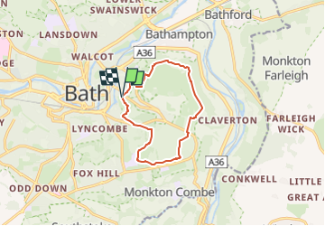
Ruta A pie de 9,3 km a descubrir en Inglaterra, Bath and North East Somerset. Esta ruta ha sido propuesta por SityTrail - itinéraires balisés pédestres.
Descripción
Explore the fascinating area around Bath along the six miles of footpaths that make up the National Trust's Bath Skyline walk.
Sitio web: https://www.nationaltrust.org.uk/bath-skyline/
Localización
País:
United Kingdom
Región :
Inglaterra
Departamento/provincia :
Bath and North East Somerset
Municipio :
Unknown
Localidad:
Unknown
Salida:(Dec)
Salida:(UTM)
545517 ; 5692343 (30U) N.
Comentarios
Excursiones cerca
![Excursión Senderismo - j9 Bath - Photo](https://media.geolcdn.com/t/375/260/ext.jpg?maxdim=2&url=https%3A%2F%2Fstatic1.geolcdn.com%2Fsiteimages%2Fupload%2Ffiles%2F1553511878bg_sport_marche.png)
![Senderismo Senderismo](https://static1.geolcdn.com/sitytour/trail-icons/101.png)
j9 Bath
Senderismo
Difícil
,
Inglaterra,
Bath and North East Somerset,
United Kingdom
![](/images/other/stat-length.png)
12,5 km | 14,6 km-effort
3h 1min
![](https://static1.geolcdn.com/siteimages/upload/files/16400158638029165_repeat_loop_refresh_sync_direction_icon.png)
No
![Excursión Senderismo - j8 Bradford on avon - Photo](https://media.geolcdn.com/t/375/260/ext.jpg?maxdim=2&url=https%3A%2F%2Fstatic1.geolcdn.com%2Fsiteimages%2Fupload%2Ffiles%2F1553511878bg_sport_marche.png)
![Senderismo Senderismo](https://static1.geolcdn.com/sitytour/trail-icons/101.png)
j8 Bradford on avon
Senderismo
Medio
,
Inglaterra,
Bath and North East Somerset,
United Kingdom
![](/images/other/stat-length.png)
9,9 km | 11,4 km-effort
2h 35min
![](https://static1.geolcdn.com/siteimages/upload/files/16400158638029165_repeat_loop_refresh_sync_direction_icon.png)
No
![Excursión Senderismo - j7 Bath Skyline, vergers, cimetière - Photo](https://media.geolcdn.com/t/375/260/ext.jpg?maxdim=2&url=https%3A%2F%2Fstatic1.geolcdn.com%2Fsiteimages%2Fupload%2Ffiles%2F1553511878bg_sport_marche.png)
![Senderismo Senderismo](https://static1.geolcdn.com/sitytour/trail-icons/101.png)
j7 Bath Skyline, vergers, cimetière
Senderismo
Difícil
,
Inglaterra,
Bath and North East Somerset,
United Kingdom
![](/images/other/stat-length.png)
10,7 km | 14,1 km-effort
3h 11min
![](https://static1.geolcdn.com/siteimages/upload/files/16400158638029165_repeat_loop_refresh_sync_direction_icon.png)
Sí