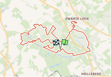
![](/images/other/stat-length.png)
![Excursión A pie Ieper - Palingbeek (entre Ypres et Comines, en Belgique) 12km - Photo](https://media.geolcdn.com/t/1900/400/ext.pjpeg?maxdim=2&url=https%3A%2F%2Fstatic1.geolcdn.com%2Fsiteimages%2Fupload%2Ffiles%2F1545311037marcheuse_200dpi.jpg)
Palingbeek (entre Ypres et Comines, en Belgique) 12km
fif59280
Usuario
![Longitud](/images/other/stat-length.png)
![Altitud máxima](https://static1.geolcdn.com/siteimages/upload/files/1508320355ic_sort_altitude_max_24dp.png)
![Desnivel positivo](https://static1.geolcdn.com/siteimages/upload/files/1508320355ic_sort_den_pos_24dp.png)
![Km-Effort](/images/other/stat-length.png)
![Altitud mínima](https://static1.geolcdn.com/siteimages/upload/files/1508320355ic_sort_altitude_min_24dp.png)
![Desnivel negativo](https://static1.geolcdn.com/siteimages/upload/files/1508320355ic_sort_den_neg_24dp.png)
![Boucle](https://static1.geolcdn.com/siteimages/upload/files/16400158638029165_repeat_loop_refresh_sync_direction_icon.png)
![A pie](https://static1.geolcdn.com/sitytour/trail-icons/100.png)
3h12
Dificultad : Fácil
![Escanee este código QR para abrir la excursión en la aplicación SityTrail](https://capi.geolives.com/qq0zvz2zws4bq2lad0pu/sitytour/trails/4339232/qr.png?size=200)
Aplicación GPS de excursión GRATIS
A propósito
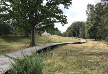
Ruta A pie de 12,3 km a descubrir en Flandes, Flandes Occidental, Ieper. Esta ruta ha sido propuesta por fif59280.
Descripción
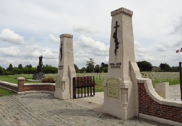
Au départ du grand parking proche du Restaurant, repartir vers la borne 13, puis passez après la traversée de route par la borne 12. Puis rejoignez la borne 27 sans suivre intégralement le fléchage (prendre une parallèle après une barrière et un panneau de terrain Privé). Passez par la borne 28 pour vous rendre au cimetière militaire, puis revenez vers le parking jusque la borne 26. Allez jusqu'à la borne 24, tournez à droite puis 2 fois à gauche pour aller à la 23 et continuer pour ensuite traverser le "Medge Row Trench Cemetery". Suivez jusque la 21, puis la 20, puis la 18, puis la 16. Passez par le "Bluff" pour rejoindre les bords de la "Oude Vaart" que vous suivrez pour rejoindre le parking en passant devant le restaurant.
Localización
Comentarios
Excursiones cerca
![Excursión A pie Heuvelland - Kraters en Mijnen - Photo](https://media.geolcdn.com/t/375/260/aaf8f233-f3c6-4670-9899-0548e3a6df10.jpeg&format=jpg&maxdim=2)
![A pie A pie](https://static1.geolcdn.com/sitytour/trail-icons/100.png)
A pie
![](/images/other/stat-length.png)
![](https://static1.geolcdn.com/siteimages/upload/files/16400158638029165_repeat_loop_refresh_sync_direction_icon.png)
![Excursión Senderismo Ieper - ypres- moitié des remparts - Photo](https://media.geolcdn.com/t/375/260/23ddc9d7-073a-4187-ba47-caf2213ec756.jpg&format=jpg&maxdim=2)
![Senderismo Senderismo](https://static1.geolcdn.com/sitytour/trail-icons/101.png)
Senderismo
![](/images/other/stat-length.png)
![](https://static1.geolcdn.com/siteimages/upload/files/16400158638029165_repeat_loop_refresh_sync_direction_icon.png)
![Excursión Senderismo Ieper - Palingbeek courte 8,4 - Photo](https://media.geolcdn.com/t/375/260/06feb11b-e53d-43cb-82a4-ec428dfd2584.jpg&format=jpg&maxdim=2)
![Senderismo Senderismo](https://static1.geolcdn.com/sitytour/trail-icons/101.png)
Senderismo
![](/images/other/stat-length.png)
![](https://static1.geolcdn.com/siteimages/upload/files/16400158638029165_repeat_loop_refresh_sync_direction_icon.png)
![Excursión Senderismo Ieper - Ypres Zillebeke vijver 17 km - Photo](https://media.geolcdn.com/t/375/260/04485afd-960b-4696-ac08-8378b35826a9.jpg&format=jpg&maxdim=2)
![Senderismo Senderismo](https://static1.geolcdn.com/sitytour/trail-icons/101.png)
Senderismo
![](/images/other/stat-length.png)
![](https://static1.geolcdn.com/siteimages/upload/files/16400158638029165_repeat_loop_refresh_sync_direction_icon.png)
![Excursión Senderismo Ieper - Ypres Yper 19 km - Photo](https://media.geolcdn.com/t/375/260/ext.jpg?maxdim=2&url=https%3A%2F%2Fservices.sitytrail.com%2FGeolivesWS%2FDownloadMedia.ashx%3FTrailID%3D1082648%26Media%3D20181209152922.jpg)
![Senderismo Senderismo](https://static1.geolcdn.com/sitytour/trail-icons/101.png)
Senderismo
![](/images/other/stat-length.png)
![](https://static1.geolcdn.com/siteimages/upload/files/16400158638029165_repeat_loop_refresh_sync_direction_icon.png)
![Excursión Motor Ieper - Eerste Wereldoorlog rond Ieper - Photo](https://media.geolcdn.com/t/375/260/ext.jpg?maxdim=2&url=https%3A%2F%2Fservices.sitytrail.com%2FGeolivesWS%2FDownloadMedia.ashx%3FTrailID%3D243034%26Media%3D9c182fe9-1bd5-41e5-8222-cea0f51d33d0.jpg)
![Motor Motor](https://static1.geolcdn.com/sitytour/trail-icons/400.png)
Motor
![](/images/other/stat-length.png)
![](https://static1.geolcdn.com/siteimages/upload/files/16400158638029165_repeat_loop_refresh_sync_direction_icon.png)
![Excursión Carrera Ieper - gasthuisbossen - Photo](https://media.geolcdn.com/t/375/260/ext.jpg?maxdim=2&url=https%3A%2F%2Fservices.sitytrail.com%2FGeolivesWS%2FDownloadMedia.ashx%3FTrailID%3D199917%26Media%3D20130623101720.jpeg)
![Carrera Carrera](https://static1.geolcdn.com/sitytour/trail-icons/103.png)
Carrera
![](/images/other/stat-length.png)
![](https://static1.geolcdn.com/siteimages/upload/files/16400158638029165_repeat_loop_refresh_sync_direction_icon.png)
![Excursión Senderismo Ieper - palingbeek 8.5km - Photo](https://media.geolcdn.com/t/375/260/8d9f189a-dff3-4658-8e25-4f99f6f79b94.jpg&format=jpg&maxdim=2)
![Senderismo Senderismo](https://static1.geolcdn.com/sitytour/trail-icons/101.png)
Senderismo
![](/images/other/stat-length.png)
![](https://static1.geolcdn.com/siteimages/upload/files/16400158638029165_repeat_loop_refresh_sync_direction_icon.png)
![Excursión Senderismo Ieper - piste synder - Photo](https://media.geolcdn.com/t/375/260/ext.jpg?maxdim=2&url=https%3A%2F%2Fstatic1.geolcdn.com%2Fsiteimages%2Fupload%2Ffiles%2F1553511878bg_sport_marche.png)
![Senderismo Senderismo](https://static1.geolcdn.com/sitytour/trail-icons/101.png)
Senderismo
![](/images/other/stat-length.png)
![](https://static1.geolcdn.com/siteimages/upload/files/16400158638029165_repeat_loop_refresh_sync_direction_icon.png)