![](/images/other/stat-length.png)
![Excursión Marcha nórdica Vandœuvre-lès-Nancy - Vandoeuvre-lès-Nancy (La Sapinière) 10 280m +192m - Photo](https://media.geolcdn.com/t/1900/400/ext.pjpeg?maxdim=2&url=https%3A%2F%2Fstatic1.geolcdn.com%2Fsiteimages%2Fupload%2Ffiles%2F1545311037marcheuse_200dpi.jpg)
Vandoeuvre-lès-Nancy (La Sapinière) 10 280m +192m
DanielROLLET
Usuario
![Longitud](/images/other/stat-length.png)
Longitud
10,3 km
![Altitud máxima](https://static1.geolcdn.com/siteimages/upload/files/1508320355ic_sort_altitude_max_24dp.png)
Altitud máxima
395 m
![Desnivel positivo](https://static1.geolcdn.com/siteimages/upload/files/1508320355ic_sort_den_pos_24dp.png)
Desnivel positivo
192 m
![Km-Effort](/images/other/stat-length.png)
Km-Effort
12,8 km
![Altitud mínima](https://static1.geolcdn.com/siteimages/upload/files/1508320355ic_sort_altitude_min_24dp.png)
Altitud mínima
258 m
![Desnivel negativo](https://static1.geolcdn.com/siteimages/upload/files/1508320355ic_sort_den_neg_24dp.png)
Desnivel negativo
192 m
![Boucle](https://static1.geolcdn.com/siteimages/upload/files/16400158638029165_repeat_loop_refresh_sync_direction_icon.png)
Boucle
Sí
Fecha de creación :
2025-01-31 07:58:50.4
Última modificación :
2025-01-31 13:38:50.879
![Marcha nórdica](https://static1.geolcdn.com/sitytour/trail-icons/102.png)
2h15
Dificultad : Muy fácil
![Escanee este código QR para abrir la excursión en la aplicación SityTrail](https://capi.geolives.com/qq0zvz2zws4bq2lad0pu/sitytour/trails/4335502/qr.png?size=200)
Aplicación GPS de excursión GRATIS
A propósito
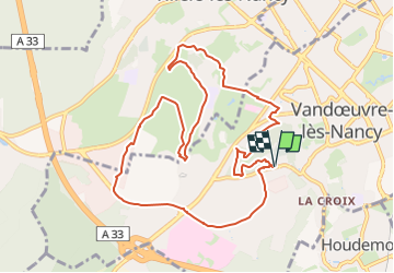
Ruta Marcha nórdica de 10,3 km a descubrir en Gran Este, Meurthe y Mosela, Vandœuvre-lès-Nancy. Esta ruta ha sido propuesta por DanielROLLET.
Descripción
2025 01 31 Reco de Marche nordique avec Marie
Temps frais,légèrement couvert et calme. Sortie nord du parc, par temps humide ne pas emprunter le sentier qui longe le grillage, rester sur un chemin au-dessus
Localización
País:
France
Región :
Gran Este
Departamento/provincia :
Meurthe y Mosela
Municipio :
Vandœuvre-lès-Nancy
Localidad:
Unknown
Salida:(Dec)
Salida:(UTM)
291002 ; 5393010 (32U) N.
Comentarios
Excursiones cerca
![Excursión A pie Fléville-devant-Nancy - Fléville-devant-Nancy et son château - Photo](https://media.geolcdn.com/t/375/260/ee7686de-cd52-43ca-b6f5-ed4c3a349bb0.jpeg&format=jpg&maxdim=2)
![A pie A pie](https://static1.geolcdn.com/sitytour/trail-icons/100.png)
Fléville-devant-Nancy et son château
A pie
Fácil
Fléville-devant-Nancy,
Gran Este,
Meurthe y Mosela,
France
![](/images/other/stat-length.png)
7,9 km | 9,4 km-effort
2h 8min
![](https://static1.geolcdn.com/siteimages/upload/files/16400158638029165_repeat_loop_refresh_sync_direction_icon.png)
Sí
![Excursión Bici eléctrica Fléville-devant-Nancy - tour dd moselle - Photo](https://media.geolcdn.com/t/375/260/ext.jpg?maxdim=2&url=https%3A%2F%2Fstatic1.geolcdn.com%2Fsiteimages%2Fupload%2Ffiles%2F1524743154velo.jpg)
![Bici eléctrica Bici eléctrica](https://static1.geolcdn.com/sitytour/trail-icons/205.png)
tour dd moselle
Bici eléctrica
Muy fácil
(1)
Fléville-devant-Nancy,
Gran Este,
Meurthe y Mosela,
France
![](/images/other/stat-length.png)
45 km | 55 km-effort
3h 0min
![](https://static1.geolcdn.com/siteimages/upload/files/16400158638029165_repeat_loop_refresh_sync_direction_icon.png)
Sí
![Excursión sport Ludres - Ludres - Photo](https://media.geolcdn.com/t/375/260/4a41c09b-4979-47d6-9e86-ddd52f153625.jpg&format=jpg&maxdim=2)
Ludres
sport
Muy fácil
Ludres,
Gran Este,
Meurthe y Mosela,
France
![](/images/other/stat-length.png)
11,6 km | 14,9 km-effort
Desconocido
![](https://static1.geolcdn.com/siteimages/upload/files/16400158638029165_repeat_loop_refresh_sync_direction_icon.png)
Sí
![Excursión Senderismo Ludres - SityTrail - Marche gourmande 11km - Photo](https://media.geolcdn.com/t/375/260/ext.jpg?maxdim=2&url=https%3A%2F%2Fstatic1.geolcdn.com%2Fsiteimages%2Fupload%2Ffiles%2F1553511878bg_sport_marche.png)
![Senderismo Senderismo](https://static1.geolcdn.com/sitytour/trail-icons/101.png)
SityTrail - Marche gourmande 11km
Senderismo
Difícil
(2)
Ludres,
Gran Este,
Meurthe y Mosela,
France
![](/images/other/stat-length.png)
10,4 km | 12,1 km-effort
2h 45min
![](https://static1.geolcdn.com/siteimages/upload/files/16400158638029165_repeat_loop_refresh_sync_direction_icon.png)
Sí
![Excursión Senderismo Nancy - Ma dernière avant opération - Photo](https://media.geolcdn.com/t/375/260/ext.jpg?maxdim=2&url=https%3A%2F%2Fstatic1.geolcdn.com%2Fsiteimages%2Fupload%2Ffiles%2F1553511878bg_sport_marche.png)
![Senderismo Senderismo](https://static1.geolcdn.com/sitytour/trail-icons/101.png)
Ma dernière avant opération
Senderismo
Muy difícil
(1)
Nancy,
Gran Este,
Meurthe y Mosela,
France
![](/images/other/stat-length.png)
22 km | 25 km-effort
4h 12min
![](https://static1.geolcdn.com/siteimages/upload/files/16400158638029165_repeat_loop_refresh_sync_direction_icon.png)
Sí
![Excursión Senderismo Vandœuvre-lès-Nancy - Randonnée USEP 2023 - Photo](https://media.geolcdn.com/t/375/260/ext.jpg?maxdim=2&url=https%3A%2F%2Fstatic1.geolcdn.com%2Fsiteimages%2Fupload%2Ffiles%2F1553511878bg_sport_marche.png)
![Senderismo Senderismo](https://static1.geolcdn.com/sitytour/trail-icons/101.png)
Randonnée USEP 2023
Senderismo
Difícil
(1)
Vandœuvre-lès-Nancy,
Gran Este,
Meurthe y Mosela,
France
![](/images/other/stat-length.png)
11,7 km | 15,2 km-effort
3h 27min
![](https://static1.geolcdn.com/siteimages/upload/files/16400158638029165_repeat_loop_refresh_sync_direction_icon.png)
No
![Excursión Senderismo Ludres - marche nuit - Photo](https://media.geolcdn.com/t/375/260/2c15af7e-0536-4068-be2b-216477912337.jpg&format=jpg&maxdim=2)
![Senderismo Senderismo](https://static1.geolcdn.com/sitytour/trail-icons/101.png)
marche nuit
Senderismo
Medio
Ludres,
Gran Este,
Meurthe y Mosela,
France
![](/images/other/stat-length.png)
8,7 km | 10,1 km-effort
2h 11min
![](https://static1.geolcdn.com/siteimages/upload/files/16400158638029165_repeat_loop_refresh_sync_direction_icon.png)
Sí
![Excursión Senderismo Nancy - Ma rando du jour - Photo](https://media.geolcdn.com/t/375/260/c990ad83-2661-43f9-99e0-4498fd5d020a.jpg&format=jpg&maxdim=2)
![Senderismo Senderismo](https://static1.geolcdn.com/sitytour/trail-icons/101.png)
Ma rando du jour
Senderismo
Difícil
Nancy,
Gran Este,
Meurthe y Mosela,
France
![](/images/other/stat-length.png)
35 km | 41 km-effort
5h 55min
![](https://static1.geolcdn.com/siteimages/upload/files/16400158638029165_repeat_loop_refresh_sync_direction_icon.png)
Sí
![Excursión Senderismo Nancy - Nancy Gondreville Nancy - Photo](https://media.geolcdn.com/t/375/260/171b4f53-1717-4b2e-9789-6c40dd8e1481.jpg&format=jpg&maxdim=2)
![Senderismo Senderismo](https://static1.geolcdn.com/sitytour/trail-icons/101.png)
Nancy Gondreville Nancy
Senderismo
Difícil
Nancy,
Gran Este,
Meurthe y Mosela,
France
![](/images/other/stat-length.png)
64 km | 74 km-effort
10h 57min
![](https://static1.geolcdn.com/siteimages/upload/files/16400158638029165_repeat_loop_refresh_sync_direction_icon.png)
Sí