![](/images/other/stat-length.png)
![Excursión Senderismo Gemeinde Fiss - Fiss-Leithe Wirt - Photo](https://media.geolcdn.com/t/1900/400/ext.pjpeg?maxdim=2&url=https%3A%2F%2Fstatic1.geolcdn.com%2Fsiteimages%2Fupload%2Ffiles%2F1553511878bg_sport_marche.png)
Fiss-Leithe Wirt
vitotin
Usuario
![Longitud](/images/other/stat-length.png)
Longitud
12,9 km
![Altitud máxima](https://static1.geolcdn.com/siteimages/upload/files/1508320355ic_sort_altitude_max_24dp.png)
Altitud máxima
1765 m
![Desnivel positivo](https://static1.geolcdn.com/siteimages/upload/files/1508320355ic_sort_den_pos_24dp.png)
Desnivel positivo
456 m
![Km-Effort](/images/other/stat-length.png)
Km-Effort
19 km
![Altitud mínima](https://static1.geolcdn.com/siteimages/upload/files/1508320355ic_sort_altitude_min_24dp.png)
Altitud mínima
1410 m
![Desnivel negativo](https://static1.geolcdn.com/siteimages/upload/files/1508320355ic_sort_den_neg_24dp.png)
Desnivel negativo
458 m
![Boucle](https://static1.geolcdn.com/siteimages/upload/files/16400158638029165_repeat_loop_refresh_sync_direction_icon.png)
Boucle
Sí
Fecha de creación :
2025-01-27 09:33:30.563
Última modificación :
2025-01-27 18:04:47.876
![Senderismo](https://static1.geolcdn.com/sitytour/trail-icons/101.png)
5h29
Dificultad : Medio
![Escanee este código QR para abrir la excursión en la aplicación SityTrail](https://capi.geolives.com/qq0zvz2zws4bq2lad0pu/sitytour/trails/4332283/qr.png?size=200)
Aplicación GPS de excursión GRATIS
A propósito
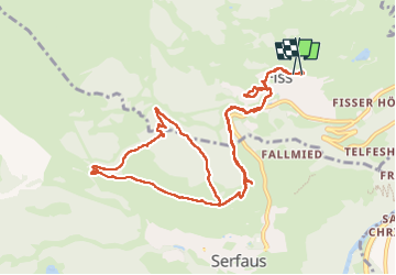
Ruta Senderismo de 12,9 km a descubrir en Tirol, Bezirk Landeck, Gemeinde Fiss. Esta ruta ha sido propuesta por vitotin.
Descripción
De appart. montée Œufs de Mooseralm puis rejoindre le parking de Waldbahn. Montée jusqu'à la marguerite par la 3.
Prendre par la droite pour rejoindre LEITHE WIRT.
Descente directe par la 4.
Retour idem
Localización
País:
Austria
Región :
Tirol
Departamento/provincia :
Bezirk Landeck
Municipio :
Gemeinde Fiss
Localidad:
Unknown
Salida:(Dec)
Salida:(UTM)
622932 ; 5212809 (32T) N.
Comentarios
Excursiones cerca
![Excursión Senderismo Gemeinde Fiss - FrommesAlm - Photo](https://media.geolcdn.com/t/375/260/ext.jpg?maxdim=2&url=https%3A%2F%2Fstatic1.geolcdn.com%2Fsiteimages%2Fupload%2Ffiles%2F1553511878bg_sport_marche.png)
![Senderismo Senderismo](https://static1.geolcdn.com/sitytour/trail-icons/101.png)
FrommesAlm
Senderismo
Medio
Gemeinde Fiss,
Tirol,
Bezirk Landeck,
Austria
![](/images/other/stat-length.png)
9,3 km | 13,6 km-effort
6h 13min
![](https://static1.geolcdn.com/siteimages/upload/files/16400158638029165_repeat_loop_refresh_sync_direction_icon.png)
Sí
![Excursión Motor Gemeinde Serfaus - a-oostenrijk-stelvio-pas - Photo](https://media.geolcdn.com/t/375/260/ext.jpg?maxdim=2&url=https%3A%2F%2Fstatic1.geolcdn.com%2Fsiteimages%2Fupload%2Ffiles%2F15247431544x4.jpg)
![Motor Motor](https://static1.geolcdn.com/sitytour/trail-icons/400.png)
a-oostenrijk-stelvio-pas
Motor
Muy fácil
Gemeinde Serfaus,
Tirol,
Bezirk Landeck,
Austria
![](/images/other/stat-length.png)
296 km | 681 km-effort
Desconocido
![](https://static1.geolcdn.com/siteimages/upload/files/16400158638029165_repeat_loop_refresh_sync_direction_icon.png)
Sí
![Excursión Motor Gemeinde Serfaus - a-oostenrijk-hochalpenstrasse - Photo](https://media.geolcdn.com/t/375/260/ext.jpg?maxdim=2&url=https%3A%2F%2Fstatic1.geolcdn.com%2Fsiteimages%2Fupload%2Ffiles%2F15247431544x4.jpg)
![Motor Motor](https://static1.geolcdn.com/sitytour/trail-icons/400.png)
a-oostenrijk-hochalpenstrasse
Motor
Muy fácil
Gemeinde Serfaus,
Tirol,
Bezirk Landeck,
Austria
![](/images/other/stat-length.png)
193 km | 462 km-effort
Desconocido
![](https://static1.geolcdn.com/siteimages/upload/files/16400158638029165_repeat_loop_refresh_sync_direction_icon.png)
Sí
![Excursión Motor Gemeinde Serfaus - a-oostenrijk-gavia-pas - Photo](https://media.geolcdn.com/t/375/260/ext.jpg?maxdim=2&url=https%3A%2F%2Fstatic1.geolcdn.com%2Fsiteimages%2Fupload%2Ffiles%2F15247431544x4.jpg)
![Motor Motor](https://static1.geolcdn.com/sitytour/trail-icons/400.png)
a-oostenrijk-gavia-pas
Motor
Muy fácil
Gemeinde Serfaus,
Tirol,
Bezirk Landeck,
Austria
![](/images/other/stat-length.png)
262 km | 584 km-effort
Desconocido
![](https://static1.geolcdn.com/siteimages/upload/files/16400158638029165_repeat_loop_refresh_sync_direction_icon.png)
Sí
![Excursión Motor Gemeinde Serfaus - a-oostenrijk-albula-pas - Photo](https://media.geolcdn.com/t/375/260/ext.jpg?maxdim=2&url=https%3A%2F%2Fstatic1.geolcdn.com%2Fsiteimages%2Fupload%2Ffiles%2F15247431544x4.jpg)
![Motor Motor](https://static1.geolcdn.com/sitytour/trail-icons/400.png)
a-oostenrijk-albula-pas
Motor
Muy fácil
Gemeinde Serfaus,
Tirol,
Bezirk Landeck,
Austria
![](/images/other/stat-length.png)
215 km | 517 km-effort
Desconocido
![](https://static1.geolcdn.com/siteimages/upload/files/16400158638029165_repeat_loop_refresh_sync_direction_icon.png)
Sí
![Excursión Senderismo Gemeinde Fiss - Aller retour à Serfais - Photo](https://media.geolcdn.com/t/375/260/ext.jpg?maxdim=2&url=https%3A%2F%2Fstatic1.geolcdn.com%2Fsiteimages%2Fupload%2Ffiles%2F1553511878bg_sport_marche.png)
![Senderismo Senderismo](https://static1.geolcdn.com/sitytour/trail-icons/101.png)
Aller retour à Serfais
Senderismo
Medio
Gemeinde Fiss,
Tirol,
Bezirk Landeck,
Austria
![](/images/other/stat-length.png)
9,6 km | 12,2 km-effort
4h 7min
![](https://static1.geolcdn.com/siteimages/upload/files/16400158638029165_repeat_loop_refresh_sync_direction_icon.png)
Sí
![Excursión Senderismo Gemeinde Fiss - Fiss - Ladis - Photo](https://media.geolcdn.com/t/375/260/ext.jpg?maxdim=2&url=https%3A%2F%2Fstatic1.geolcdn.com%2Fsiteimages%2Fupload%2Ffiles%2F1553511878bg_sport_marche.png)
![Senderismo Senderismo](https://static1.geolcdn.com/sitytour/trail-icons/101.png)
Fiss - Ladis
Senderismo
Medio
Gemeinde Fiss,
Tirol,
Bezirk Landeck,
Austria
![](/images/other/stat-length.png)
7,4 km | 10,8 km-effort
4h 18min
![](https://static1.geolcdn.com/siteimages/upload/files/16400158638029165_repeat_loop_refresh_sync_direction_icon.png)
Sí
![Excursión Senderismo Gemeinde Fiss - Les Crêtes : Fiss - Serfaus - Photo](https://media.geolcdn.com/t/375/260/ext.jpg?maxdim=2&url=https%3A%2F%2Fstatic1.geolcdn.com%2Fsiteimages%2Fupload%2Ffiles%2F1553511878bg_sport_marche.png)
![Senderismo Senderismo](https://static1.geolcdn.com/sitytour/trail-icons/101.png)
Les Crêtes : Fiss - Serfaus
Senderismo
Difícil
Gemeinde Fiss,
Tirol,
Bezirk Landeck,
Austria
![](/images/other/stat-length.png)
9,3 km | 17,6 km-effort
3h 9min
![](https://static1.geolcdn.com/siteimages/upload/files/16400158638029165_repeat_loop_refresh_sync_direction_icon.png)
No
![Excursión Senderismo Gemeinde Fiss - Ladis_2023-07-15 - Photo](https://media.geolcdn.com/t/375/260/ext.jpg?maxdim=2&url=https%3A%2F%2Fstatic1.geolcdn.com%2Fsiteimages%2Fupload%2Ffiles%2F1553511878bg_sport_marche.png)
![Senderismo Senderismo](https://static1.geolcdn.com/sitytour/trail-icons/101.png)
Ladis_2023-07-15
Senderismo
Difícil
Gemeinde Fiss,
Tirol,
Bezirk Landeck,
Austria
![](/images/other/stat-length.png)
10,4 km | 14,8 km-effort
3h 13min
![](https://static1.geolcdn.com/siteimages/upload/files/16400158638029165_repeat_loop_refresh_sync_direction_icon.png)
No