![](/images/other/stat-length.png)
![Excursión Marcha nórdica Ver-sur-Launette - Chapelle sainte Marguerite - Photo](https://media.geolcdn.com/t/1900/400/ext.pjpeg?maxdim=2&url=https%3A%2F%2Fstatic1.geolcdn.com%2Fsiteimages%2Fupload%2Ffiles%2F1545311037marcheuse_200dpi.jpg)
Chapelle sainte Marguerite
damerenvielle@gmail.com
Usuario
![Longitud](/images/other/stat-length.png)
![Altitud máxima](https://static1.geolcdn.com/siteimages/upload/files/1508320355ic_sort_altitude_max_24dp.png)
![Desnivel positivo](https://static1.geolcdn.com/siteimages/upload/files/1508320355ic_sort_den_pos_24dp.png)
![Km-Effort](/images/other/stat-length.png)
![Altitud mínima](https://static1.geolcdn.com/siteimages/upload/files/1508320355ic_sort_altitude_min_24dp.png)
![Desnivel negativo](https://static1.geolcdn.com/siteimages/upload/files/1508320355ic_sort_den_neg_24dp.png)
![Boucle](https://static1.geolcdn.com/siteimages/upload/files/16400158638029165_repeat_loop_refresh_sync_direction_icon.png)
![Marcha nórdica](https://static1.geolcdn.com/sitytour/trail-icons/102.png)
2h18
Dificultad : Fácil
![Escanee este código QR para abrir la excursión en la aplicación SityTrail](https://capi.geolives.com/qq0zvz2zws4bq2lad0pu/sitytour/trails/4310439/qr.png?size=200)
Aplicación GPS de excursión GRATIS
A propósito
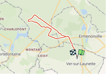
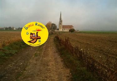
Ruta Marcha nórdica de 13,4 km a descubrir en Alta Francia, Oise, Ver-sur-Launette. Esta ruta ha sido propuesta por damerenvielle@gmail.com.
Descripción
Au départ de Ver Sur Launette, en passant par l'aire de pique nique de Boisdhyver, le pavillon du prince, carrefour du carreau, carrefour du peuple, puis proche de la chapelle retour par le carrefour du bosquet rond et sur la route du même nom, la route anglaise et le pavillon du prince.
Localización
Comentarios
Excursiones cerca
![Excursión Senderismo Ermenonville - SM_ERMENONVILLE CHATEAU_NORD_8.1Km - Photo](https://media.geolcdn.com/t/375/260/7d446e19-5e6a-43bb-b3e7-8604a42003f5.jpg&format=jpg&maxdim=2)
![Senderismo Senderismo](https://static1.geolcdn.com/sitytour/trail-icons/101.png)
Senderismo
![](/images/other/stat-length.png)
![](https://static1.geolcdn.com/siteimages/upload/files/16400158638029165_repeat_loop_refresh_sync_direction_icon.png)
![Excursión Senderismo Fontaine-Chaalis - Abbaye de Chaalis+fiche+GPX_ 7,8Km_SM - Photo](https://media.geolcdn.com/t/375/260/657f82f2-464a-46f3-a6d5-6815f63cb655.jpg&format=jpg&maxdim=2)
![Senderismo Senderismo](https://static1.geolcdn.com/sitytour/trail-icons/101.png)
Senderismo
![](/images/other/stat-length.png)
![](https://static1.geolcdn.com/siteimages/upload/files/16400158638029165_repeat_loop_refresh_sync_direction_icon.png)
![Excursión Senderismo Ver-sur-Launette - SM_VER-sur-LAUNETTE_8.5Km - Photo](https://media.geolcdn.com/t/375/260/e4a0fe41-690f-4014-9611-5ec255c04f3d.jpg&format=jpg&maxdim=2)
![Senderismo Senderismo](https://static1.geolcdn.com/sitytour/trail-icons/101.png)
Senderismo
![](/images/other/stat-length.png)
![](https://static1.geolcdn.com/siteimages/upload/files/16400158638029165_repeat_loop_refresh_sync_direction_icon.png)
![Excursión Senderismo Fontaine-Chaalis - Abbaye de Chaalis Supermini Rando - Photo](https://media.geolcdn.com/t/375/260/15af4e3c-b372-40df-abf5-027cf19e5dd0.jpg&format=jpg&maxdim=2)
![Senderismo Senderismo](https://static1.geolcdn.com/sitytour/trail-icons/101.png)
Senderismo
![](/images/other/stat-length.png)
![](https://static1.geolcdn.com/siteimages/upload/files/16400158638029165_repeat_loop_refresh_sync_direction_icon.png)
![Excursión Senderismo Ermenonville - Ermenonville Chateau 6,3 Km - Photo](https://media.geolcdn.com/t/375/260/4ced2ae2-3324-4103-b3b1-afffd891ea1f.jpg&format=jpg&maxdim=2)
![Senderismo Senderismo](https://static1.geolcdn.com/sitytour/trail-icons/101.png)
Senderismo
![](/images/other/stat-length.png)
![](https://static1.geolcdn.com/siteimages/upload/files/16400158638029165_repeat_loop_refresh_sync_direction_icon.png)
![Excursión Senderismo Montagny-Sainte-Félicité - SM_MONTAGNY_Ste-FELECITE_8.5Km - Photo](https://media.geolcdn.com/t/375/260/7f77d429-995c-4fbd-8931-c05c864ab4aa.jpg&format=jpg&maxdim=2)
![Senderismo Senderismo](https://static1.geolcdn.com/sitytour/trail-icons/101.png)
Senderismo
![](/images/other/stat-length.png)
![](https://static1.geolcdn.com/siteimages/upload/files/16400158638029165_repeat_loop_refresh_sync_direction_icon.png)
![Excursión Senderismo Ver-sur-Launette - SM_LOISY_8.5Km - Photo](https://media.geolcdn.com/t/375/260/11537f1c-9100-4fb5-a43a-20a54cad8fb4.jpg&format=jpg&maxdim=2)
![Senderismo Senderismo](https://static1.geolcdn.com/sitytour/trail-icons/101.png)
Senderismo
![](/images/other/stat-length.png)
![](https://static1.geolcdn.com/siteimages/upload/files/16400158638029165_repeat_loop_refresh_sync_direction_icon.png)
![Excursión Senderismo Othis - SM_BEAUMARCHAIS_8.2Km - Photo](https://media.geolcdn.com/t/375/260/77e12fa5-e8b4-47fd-984a-c11823705817.jpg&format=jpg&maxdim=2)
![Senderismo Senderismo](https://static1.geolcdn.com/sitytour/trail-icons/101.png)
Senderismo
![](/images/other/stat-length.png)
![](https://static1.geolcdn.com/siteimages/upload/files/16400158638029165_repeat_loop_refresh_sync_direction_icon.png)
![Excursión Senderismo Fontaine-Chaalis - MR_ERMENONVILLE-Maison-Blanche_EST_5.8Km - Photo](https://media.geolcdn.com/t/375/260/9923fd81-5d90-403c-9e41-4a668aba5ad7.jpg&format=jpg&maxdim=2)
![Senderismo Senderismo](https://static1.geolcdn.com/sitytour/trail-icons/101.png)
Senderismo
![](/images/other/stat-length.png)
![](https://static1.geolcdn.com/siteimages/upload/files/16400158638029165_repeat_loop_refresh_sync_direction_icon.png)