![](/images/other/stat-length.png)
![Excursión Senderismo Bourg-Saint-Pierre - Tour du Saint-Bernard - Photo](https://media.geolcdn.com/t/1900/400/ext.pjpeg?maxdim=2&url=https%3A%2F%2Fstatic1.geolcdn.com%2Fsiteimages%2Fupload%2Ffiles%2F1553511878bg_sport_marche.png)
Tour du Saint-Bernard
verbier
Usuario
![Longitud](/images/other/stat-length.png)
![Altitud máxima](https://static1.geolcdn.com/siteimages/upload/files/1508320355ic_sort_altitude_max_24dp.png)
![Desnivel positivo](https://static1.geolcdn.com/siteimages/upload/files/1508320355ic_sort_den_pos_24dp.png)
![Km-Effort](/images/other/stat-length.png)
![Altitud mínima](https://static1.geolcdn.com/siteimages/upload/files/1508320355ic_sort_altitude_min_24dp.png)
![Desnivel negativo](https://static1.geolcdn.com/siteimages/upload/files/1508320355ic_sort_den_neg_24dp.png)
![Boucle](https://static1.geolcdn.com/siteimages/upload/files/16400158638029165_repeat_loop_refresh_sync_direction_icon.png)
![Senderismo](https://static1.geolcdn.com/sitytour/trail-icons/101.png)
36h00
Dificultad : Desconocido
![Escanee este código QR para abrir la excursión en la aplicación SityTrail](https://capi.geolives.com/qq0zvz2zws4bq2lad0pu/sitytour/trails/43026/qr.png?size=200)
Aplicación GPS de excursión GRATIS
A propósito
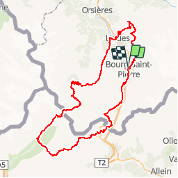
Ruta Senderismo de 85 km a descubrir en Vallés, Entremont, Bourg-Saint-Pierre. Esta ruta ha sido propuesta por verbier.
Descripción
Start from Bg-St-Pierre, in direction of the Gd-St-Bernard pass. A night at the pass, in the company of the St-Bernards.
The 2nd day will take you to Italy, with a night at the Bonatty hut, or in Lavachey. Wild landscapes during the crossing to the Malatra pass (2900m).
Back in Switzerland for the 3rd day, with the entry by the Gd-Col-Ferret, and stretch towards La Peule.
Steep ascent to the Basset pass for the 4th day. Then, downhill slope in the Combe de lA and its natural reserve. Night in La Tsissette.
The following day, stretch towards Liddes, and quite long ascent to the Mille hut.
Last stage with the descent towards Bg-St-Pierre. Optional crossing to the Mt-Rogneux.
More informations on www.tourdusaintbernard.com
Localización
Comentarios
Excursiones cerca
![Excursión Senderismo Liddes - Combe de l’A - Photo](https://media.geolcdn.com/t/375/260/80b3ab05-1db2-4115-987f-2856a50ccafd.jpg&format=jpg&maxdim=2)
![Senderismo Senderismo](https://static1.geolcdn.com/sitytour/trail-icons/101.png)
Senderismo
![](/images/other/stat-length.png)
![](https://static1.geolcdn.com/siteimages/upload/files/16400158638029165_repeat_loop_refresh_sync_direction_icon.png)
![Excursión Senderismo Liddes - vs_hike680c - Photo](https://media.geolcdn.com/t/375/260/ext.jpg?maxdim=2&url=https%3A%2F%2Fstatic1.geolcdn.com%2Fsiteimages%2Fupload%2Ffiles%2F1553511878bg_sport_marche.png)
![Senderismo Senderismo](https://static1.geolcdn.com/sitytour/trail-icons/101.png)
Senderismo
![](/images/other/stat-length.png)
![](https://static1.geolcdn.com/siteimages/upload/files/16400158638029165_repeat_loop_refresh_sync_direction_icon.png)
![Excursión Senderismo Liddes - Liddes, Bec Rond - Photo](https://media.geolcdn.com/t/375/260/ext.jpg?maxdim=2&url=https%3A%2F%2Fstatic1.geolcdn.com%2Fsiteimages%2Fupload%2Ffiles%2F1553511878bg_sport_marche.png)
![Senderismo Senderismo](https://static1.geolcdn.com/sitytour/trail-icons/101.png)
Senderismo
![](/images/other/stat-length.png)
![](https://static1.geolcdn.com/siteimages/upload/files/16400158638029165_repeat_loop_refresh_sync_direction_icon.png)
![Excursión Senderismo Bourg-Saint-Pierre - Tour des Combins - Photo](https://media.geolcdn.com/t/375/260/ext.jpg?maxdim=2&url=https%3A%2F%2Fstatic1.geolcdn.com%2Fsiteimages%2Fupload%2Ffiles%2F1553511878bg_sport_marche.png)
![Senderismo Senderismo](https://static1.geolcdn.com/sitytour/trail-icons/101.png)
Senderismo
![](/images/other/stat-length.png)
![](https://static1.geolcdn.com/siteimages/upload/files/16400158638029165_repeat_loop_refresh_sync_direction_icon.png)
![Excursión Senderismo Bourg-Saint-Pierre - Bourg-St-Pierre, Cabane du Vélan - Photo](https://media.geolcdn.com/t/375/260/ext.jpg?maxdim=2&url=https%3A%2F%2Fstatic1.geolcdn.com%2Fsiteimages%2Fupload%2Ffiles%2F1553511878bg_sport_marche.png)
![Senderismo Senderismo](https://static1.geolcdn.com/sitytour/trail-icons/101.png)
Senderismo
![](/images/other/stat-length.png)
![](https://static1.geolcdn.com/siteimages/upload/files/16400158638029165_repeat_loop_refresh_sync_direction_icon.png)
![Excursión Senderismo Bourg-Saint-Pierre - Bourg-St-Pierre, Becca Colinte - Photo](https://media.geolcdn.com/t/375/260/ext.jpg?maxdim=2&url=https%3A%2F%2Fstatic1.geolcdn.com%2Fsiteimages%2Fupload%2Ffiles%2F1553511878bg_sport_marche.png)
![Senderismo Senderismo](https://static1.geolcdn.com/sitytour/trail-icons/101.png)
Senderismo
![](/images/other/stat-length.png)
![](https://static1.geolcdn.com/siteimages/upload/files/16400158638029165_repeat_loop_refresh_sync_direction_icon.png)
![Excursión Raquetas de nieve Liddes - Liddes, Sentier Raquettes n° 12, Plan Beu - Photo](https://media.geolcdn.com/t/375/260/ext.jpg?maxdim=2&url=https%3A%2F%2Fstatic1.geolcdn.com%2Fsiteimages%2Fupload%2Ffiles%2F1524743153raquette.jpg)
![Raquetas de nieve Raquetas de nieve](https://static1.geolcdn.com/sitytour/trail-icons/504.png)
Raquetas de nieve
![](/images/other/stat-length.png)
![](https://static1.geolcdn.com/siteimages/upload/files/16400158638029165_repeat_loop_refresh_sync_direction_icon.png)
![Excursión Raquetas de nieve Bourg-Saint-Pierre - Bourg-St-Pierre, Sentier Raquettes n° 9, L''Oratoire - Photo](https://media.geolcdn.com/t/375/260/ext.jpg?maxdim=2&url=https%3A%2F%2Fstatic1.geolcdn.com%2Fsiteimages%2Fupload%2Ffiles%2F1524743153raquette.jpg)
![Raquetas de nieve Raquetas de nieve](https://static1.geolcdn.com/sitytour/trail-icons/504.png)
Raquetas de nieve
![](/images/other/stat-length.png)
![](https://static1.geolcdn.com/siteimages/upload/files/16400158638029165_repeat_loop_refresh_sync_direction_icon.png)
![Excursión Raquetas de nieve Liddes - Liddes, Sentier Raquettes n° 8, Les Daims - Photo](https://media.geolcdn.com/t/375/260/ext.jpg?maxdim=2&url=https%3A%2F%2Fstatic1.geolcdn.com%2Fsiteimages%2Fupload%2Ffiles%2F1524743153raquette.jpg)
![Raquetas de nieve Raquetas de nieve](https://static1.geolcdn.com/sitytour/trail-icons/504.png)
Raquetas de nieve
![](/images/other/stat-length.png)
![](https://static1.geolcdn.com/siteimages/upload/files/16400158638029165_repeat_loop_refresh_sync_direction_icon.png)