![](/images/other/stat-length.png)
![Excursión Senderismo Bourg-Saint-Pierre - Hospice du Grand-Saint-Bernard - Photo](https://media.geolcdn.com/t/1900/400/ext.pjpeg?maxdim=2&url=https%3A%2F%2Fservices.sitytrail.com%2FGeolivesWS%2FDownloadMedia.ashx%3FTrailID%3D43016%26Media%3Dimage0.jpg)
Hospice du Grand-Saint-Bernard
verbier
Usuario
![Longitud](/images/other/stat-length.png)
Longitud
4,8 km
![Altitud máxima](https://static1.geolcdn.com/siteimages/upload/files/1508320355ic_sort_altitude_max_24dp.png)
Altitud máxima
2478 m
![Desnivel positivo](https://static1.geolcdn.com/siteimages/upload/files/1508320355ic_sort_den_pos_24dp.png)
Desnivel positivo
537 m
![Km-Effort](/images/other/stat-length.png)
Km-Effort
10,2 km
![Altitud mínima](https://static1.geolcdn.com/siteimages/upload/files/1508320355ic_sort_altitude_min_24dp.png)
Altitud mínima
1936 m
![Desnivel negativo](https://static1.geolcdn.com/siteimages/upload/files/1508320355ic_sort_den_neg_24dp.png)
Desnivel negativo
0 m
![Boucle](https://static1.geolcdn.com/siteimages/upload/files/16400158638029165_repeat_loop_refresh_sync_direction_icon.png)
Boucle
No
Fecha de creación :
2014-12-10 00:00:00.0
Última modificación :
2014-12-10 00:00:00.0
![Senderismo](https://static1.geolcdn.com/sitytour/trail-icons/101.png)
2h39
Dificultad : Desconocido
![Escanee este código QR para abrir la excursión en la aplicación SityTrail](https://capi.geolives.com/qq0zvz2zws4bq2lad0pu/sitytour/trails/43016/qr.png?size=200)
Aplicación GPS de excursión GRATIS
A propósito
Ruta Senderismo de 4,8 km a descubrir en Vallés, Entremont, Bourg-Saint-Pierre. Esta ruta ha sido propuesta por verbier.
Descripción
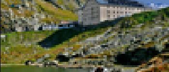
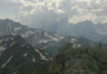
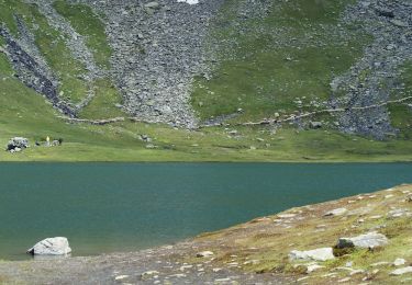
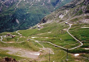
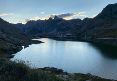
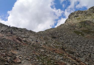
From Bourg-St-Bernard, the path goes up to the south for an easy ascent to the Combe de Barasson. From there, the ascent is a little bit unflagging in the Combe des Morts during around 30 minutes to meet the hospice.
Localización
País:
Switzerland
Región :
Vallés
Departamento/provincia :
Entremont
Municipio :
Bourg-Saint-Pierre
Localidad:
Unknown
Salida:(Dec)
Salida:(UTM)
360038 ; 5084411 (32T) N.
Comentarios
Excursiones cerca
![Excursión Senderismo Bourg-Saint-Pierre - st. Bernard - Photo](https://media.geolcdn.com/t/375/260/ext.jpg?maxdim=2&url=https%3A%2F%2Fservices.sitytrail.com%2FGeolivesWS%2FDownloadMedia.ashx%3FTrailID%3D210266%26Media%3Dfix__20130804173737.jpg)
![Senderismo Senderismo](https://static1.geolcdn.com/sitytour/trail-icons/101.png)
st. Bernard
Senderismo
Muy fácil
(2)
Bourg-Saint-Pierre,
Vallés,
Entremont,
Switzerland
![](/images/other/stat-length.png)
44 km | 116 km-effort
6h 17min
![](https://static1.geolcdn.com/siteimages/upload/files/16400158638029165_repeat_loop_refresh_sync_direction_icon.png)
No
![Excursión A pie Bourg-Saint-Pierre - Chemins pédestres, région St-Bernard - Photo](https://media.geolcdn.com/t/375/260/3ecb502d-aa39-43c7-b4fa-d2f145975573.jpeg&format=jpg&maxdim=2)
![A pie A pie](https://static1.geolcdn.com/sitytour/trail-icons/100.png)
Chemins pédestres, région St-Bernard
A pie
Fácil
Bourg-Saint-Pierre,
Vallés,
Entremont,
Switzerland
![](/images/other/stat-length.png)
8,6 km | 18,8 km-effort
4h 15min
![](https://static1.geolcdn.com/siteimages/upload/files/16400158638029165_repeat_loop_refresh_sync_direction_icon.png)
No
![Excursión A pie Bourg-Saint-Pierre - Via Alpina Red R117 - Photo](https://media.geolcdn.com/t/375/260/13ce668d-e692-4cf0-91fa-ed93365ce626.jpeg&format=jpg&maxdim=2)
![A pie A pie](https://static1.geolcdn.com/sitytour/trail-icons/100.png)
Via Alpina Red R117
A pie
Muy difícil
Bourg-Saint-Pierre,
Vallés,
Entremont,
Switzerland
![](/images/other/stat-length.png)
27 km | 46 km-effort
10h 25min
![](https://static1.geolcdn.com/siteimages/upload/files/16400158638029165_repeat_loop_refresh_sync_direction_icon.png)
No
![Excursión A pie Bourg-Saint-Pierre - Tour du Lac des Toules - Photo](https://media.geolcdn.com/t/375/260/dafbc912-1c22-4e42-aaf9-5568981fc800.jpeg&format=jpg&maxdim=2)
![A pie A pie](https://static1.geolcdn.com/sitytour/trail-icons/100.png)
Tour du Lac des Toules
A pie
Medio
Bourg-Saint-Pierre,
Vallés,
Entremont,
Switzerland
![](/images/other/stat-length.png)
14,4 km | 25 km-effort
5h 44min
![](https://static1.geolcdn.com/siteimages/upload/files/16400158638029165_repeat_loop_refresh_sync_direction_icon.png)
Sí
![Excursión Senderismo Bourg-Saint-Pierre - St Bernard - Photo](https://media.geolcdn.com/t/375/260/1947af24-c4d5-4de6-a636-7c1ee087fc5c.jpg&format=jpg&maxdim=2)
![Senderismo Senderismo](https://static1.geolcdn.com/sitytour/trail-icons/101.png)
St Bernard
Senderismo
Medio
Bourg-Saint-Pierre,
Vallés,
Entremont,
Switzerland
![](/images/other/stat-length.png)
4,7 km | 8,1 km-effort
2h 49min
![](https://static1.geolcdn.com/siteimages/upload/files/16400158638029165_repeat_loop_refresh_sync_direction_icon.png)
Sí
![Excursión Senderismo Saint-Rhémy-en-Bosses - col du St Bernard - Photo](https://media.geolcdn.com/t/375/260/5879026c-ce90-4863-bb5e-9ebd059c362b.jpg&format=jpg&maxdim=2)
![Senderismo Senderismo](https://static1.geolcdn.com/sitytour/trail-icons/101.png)
col du St Bernard
Senderismo
Fácil
Saint-Rhémy-en-Bosses,
Valle de Aosta,
Desconocido,
Italy
![](/images/other/stat-length.png)
1,8 km | 4,5 km-effort
2h 21min
![](https://static1.geolcdn.com/siteimages/upload/files/16400158638029165_repeat_loop_refresh_sync_direction_icon.png)
No
![Excursión Esquí de fondo Bourg-Saint-Pierre - col du Grand st Bernard - Photo](https://media.geolcdn.com/t/375/260/ext.jpg?maxdim=2&url=https%3A%2F%2Fstatic1.geolcdn.com%2Fsiteimages%2Fupload%2Ffiles%2F1524743154ski_fond.jpg)
![Esquí de fondo Esquí de fondo](https://static1.geolcdn.com/sitytour/trail-icons/503.png)
col du Grand st Bernard
Esquí de fondo
Muy fácil
Bourg-Saint-Pierre,
Vallés,
Entremont,
Switzerland
![](/images/other/stat-length.png)
5,1 km | 10,5 km-effort
2h 15min
![](https://static1.geolcdn.com/siteimages/upload/files/16400158638029165_repeat_loop_refresh_sync_direction_icon.png)
No
![Excursión Deportes de invierno Bourg-Saint-Pierre - Mont Fourchu - Photo](https://media.geolcdn.com/t/375/260/ext.jpg?maxdim=2&url=https%3A%2F%2Fstatic1.geolcdn.com%2Fsiteimages%2Fupload%2Ffiles%2F1524743153ski.jpg)
![Deportes de invierno Deportes de invierno](https://static1.geolcdn.com/sitytour/trail-icons/500.png)
Mont Fourchu
Deportes de invierno
Medio
Bourg-Saint-Pierre,
Vallés,
Entremont,
Switzerland
![](/images/other/stat-length.png)
4,5 km | 10 km-effort
3h 0min
![](https://static1.geolcdn.com/siteimages/upload/files/16400158638029165_repeat_loop_refresh_sync_direction_icon.png)
No
![Excursión Senderismo Bourg-Saint-Pierre - Bourg-St-Pierre, Cabane du Vélan - Photo](https://media.geolcdn.com/t/375/260/ext.jpg?maxdim=2&url=https%3A%2F%2Fstatic1.geolcdn.com%2Fsiteimages%2Fupload%2Ffiles%2F1553511878bg_sport_marche.png)
![Senderismo Senderismo](https://static1.geolcdn.com/sitytour/trail-icons/101.png)
Bourg-St-Pierre, Cabane du Vélan
Senderismo
Muy fácil
Bourg-Saint-Pierre,
Vallés,
Entremont,
Switzerland
![](/images/other/stat-length.png)
9,5 km | 19,8 km-effort
5h 30min
![](https://static1.geolcdn.com/siteimages/upload/files/16400158638029165_repeat_loop_refresh_sync_direction_icon.png)
Sí
approche