![](/images/other/stat-length.png)
![Excursión Senderismo Maulévrier-Sainte-Gertrude - Maulévrier-Sainte-Gertrude (144) - Photo](https://media.geolcdn.com/t/1900/400/ext.pjpeg?maxdim=2&url=https%3A%2F%2Fstatic1.geolcdn.com%2Fsiteimages%2Fupload%2Ffiles%2F1553511878bg_sport_marche.png)
Maulévrier-Sainte-Gertrude (144)
randovivi
Usuario
![Longitud](/images/other/stat-length.png)
Longitud
12,1 km
![Altitud máxima](https://static1.geolcdn.com/siteimages/upload/files/1508320355ic_sort_altitude_max_24dp.png)
Altitud máxima
128 m
![Desnivel positivo](https://static1.geolcdn.com/siteimages/upload/files/1508320355ic_sort_den_pos_24dp.png)
Desnivel positivo
374 m
![Km-Effort](/images/other/stat-length.png)
Km-Effort
17,1 km
![Altitud mínima](https://static1.geolcdn.com/siteimages/upload/files/1508320355ic_sort_altitude_min_24dp.png)
Altitud mínima
21 m
![Desnivel negativo](https://static1.geolcdn.com/siteimages/upload/files/1508320355ic_sort_den_neg_24dp.png)
Desnivel negativo
374 m
![Boucle](https://static1.geolcdn.com/siteimages/upload/files/16400158638029165_repeat_loop_refresh_sync_direction_icon.png)
Boucle
Sí
Fecha de creación :
2024-11-25 17:04:44.643
Última modificación :
2025-01-10 18:29:35.18
![Senderismo](https://static1.geolcdn.com/sitytour/trail-icons/101.png)
3h53
Dificultad : Difícil
![Escanee este código QR para abrir la excursión en la aplicación SityTrail](https://capi.geolives.com/qq0zvz2zws4bq2lad0pu/sitytour/trails/4280434/qr.png?size=200)
Aplicación GPS de excursión GRATIS
A propósito
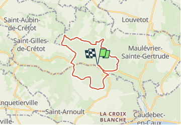
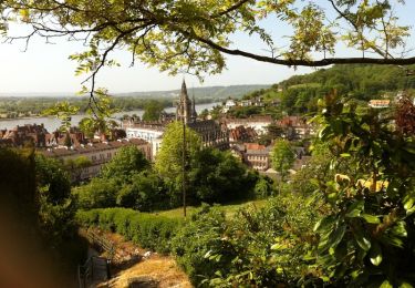
Ruta Senderismo de 12,1 km a descubrir en Normandía, Sena-Marítimo, Maulévrier-Sainte-Gertrude. Esta ruta ha sido propuesta por randovivi.
Descripción
Départ Parking dans la forêt à coté des tables Pique Nique sur la gauche du hêtre Serpent. ( Cette Randonnée est plus dure qu'il n'y parait ) Pique Nique à prévoir en cours.
Localización
País:
France
Región :
Normandía
Departamento/provincia :
Sena-Marítimo
Municipio :
Maulévrier-Sainte-Gertrude
Localidad:
Unknown
Salida:(Dec)
Salida:(UTM)
332858 ; 5491113 (31U) N.
Comentarios
Excursiones cerca
![Excursión Senderismo Rives-en-Seine - Balade à Villequier - Photo](https://media.geolcdn.com/t/375/260/ext.jpg?maxdim=2&url=https%3A%2F%2Fservices.sitytrail.com%2FGeolivesWS%2FDownloadMedia.ashx%3FTrailID%3D107143%26Media%3D11983_1.jpg)
![Senderismo Senderismo](https://static1.geolcdn.com/sitytour/trail-icons/101.png)
Balade à Villequier
Senderismo
Fácil
(1)
Rives-en-Seine,
Normandía,
Sena-Marítimo,
France
![](/images/other/stat-length.png)
9,7 km | 12,5 km-effort
2h 0min
![](https://static1.geolcdn.com/siteimages/upload/files/16400158638029165_repeat_loop_refresh_sync_direction_icon.png)
Sí
![Excursión Senderismo Rives-en-Seine - saint wandrille 76 - Photo](https://media.geolcdn.com/t/375/260/93ae6a7b-c754-44fd-a552-6b50bdaf0db6.jpg&format=jpg&maxdim=2)
![Senderismo Senderismo](https://static1.geolcdn.com/sitytour/trail-icons/101.png)
saint wandrille 76
Senderismo
Medio
Rives-en-Seine,
Normandía,
Sena-Marítimo,
France
![](/images/other/stat-length.png)
8,7 km | 11,5 km-effort
2h 41min
![](https://static1.geolcdn.com/siteimages/upload/files/16400158638029165_repeat_loop_refresh_sync_direction_icon.png)
Sí
![Senderismo Senderismo](https://static1.geolcdn.com/sitytour/trail-icons/101.png)
20220421-Caudebec en Caux Journée
Senderismo
Medio
Rives-en-Seine,
Normandía,
Sena-Marítimo,
France
![](/images/other/stat-length.png)
21 km | 27 km-effort
6h 34min
![](https://static1.geolcdn.com/siteimages/upload/files/16400158638029165_repeat_loop_refresh_sync_direction_icon.png)
Sí
![Excursión Senderismo Arelaune-en-Seine - Saint-Nicolas de Bliquetuit (Vers l'Armada) - Photo](https://media.geolcdn.com/t/375/260/ext.jpg?maxdim=2&url=https%3A%2F%2Fservices.sitytrail.com%2FGeolivesWS%2FDownloadMedia.ashx%3FTrailID%3D1136283%26Media%3Dfix__20190418123539.jpg)
![Senderismo Senderismo](https://static1.geolcdn.com/sitytour/trail-icons/101.png)
Saint-Nicolas de Bliquetuit (Vers l'Armada)
Senderismo
Muy fácil
Arelaune-en-Seine,
Normandía,
Sena-Marítimo,
France
![](/images/other/stat-length.png)
11,2 km | 12,2 km-effort
2h 32min
![](https://static1.geolcdn.com/siteimages/upload/files/16400158638029165_repeat_loop_refresh_sync_direction_icon.png)
Sí
![Excursión Senderismo Rives-en-Seine - Villequier - Photo](https://media.geolcdn.com/t/375/260/1a222259-4005-4e3b-b3b0-cebb77b1dd57.jpg&format=jpg&maxdim=2)
![Senderismo Senderismo](https://static1.geolcdn.com/sitytour/trail-icons/101.png)
Villequier
Senderismo
Medio
Rives-en-Seine,
Normandía,
Sena-Marítimo,
France
![](/images/other/stat-length.png)
9,3 km | 12 km-effort
2h 23min
![](https://static1.geolcdn.com/siteimages/upload/files/16400158638029165_repeat_loop_refresh_sync_direction_icon.png)
Sí
![Excursión Senderismo Rives-en-Seine - les hauts de caudebecq en caux - Photo](https://media.geolcdn.com/t/375/260/b97d3d2d-20d6-4f00-971a-82fbdaf6cde5.jpg&format=jpg&maxdim=2)
![Senderismo Senderismo](https://static1.geolcdn.com/sitytour/trail-icons/101.png)
les hauts de caudebecq en caux
Senderismo
Fácil
Rives-en-Seine,
Normandía,
Sena-Marítimo,
France
![](/images/other/stat-length.png)
10 km | 13,3 km-effort
2h 32min
![](https://static1.geolcdn.com/siteimages/upload/files/16400158638029165_repeat_loop_refresh_sync_direction_icon.png)
Sí
![Excursión Senderismo Saint-Aubin-de-Crétot - St Aubin de Crétot - Photo](https://media.geolcdn.com/t/375/260/ext.jpg?maxdim=2&url=https%3A%2F%2Fservices.sitytrail.com%2FGeolivesWS%2FDownloadMedia.ashx%3FTrailID%3D107050%26Media%3D11860_1.jpg)
![Senderismo Senderismo](https://static1.geolcdn.com/sitytour/trail-icons/101.png)
St Aubin de Crétot
Senderismo
Medio
Saint-Aubin-de-Crétot,
Normandía,
Sena-Marítimo,
France
![](/images/other/stat-length.png)
17,8 km | 23 km-effort
3h 40min
![](https://static1.geolcdn.com/siteimages/upload/files/16400158638029165_repeat_loop_refresh_sync_direction_icon.png)
No
![Excursión Senderismo Rives-en-Seine - Caudebec en Caux - Photo](https://media.geolcdn.com/t/375/260/ext.jpg?maxdim=2&url=https%3A%2F%2Fservices.sitytrail.com%2FGeolivesWS%2FDownloadMedia.ashx%3FTrailID%3D107049%26Media%3D11859_1.jpg)
![Senderismo Senderismo](https://static1.geolcdn.com/sitytour/trail-icons/101.png)
Caudebec en Caux
Senderismo
Medio
Rives-en-Seine,
Normandía,
Sena-Marítimo,
France
![](/images/other/stat-length.png)
20 km | 26 km-effort
4h 0min
![](https://static1.geolcdn.com/siteimages/upload/files/16400158638029165_repeat_loop_refresh_sync_direction_icon.png)
Sí
![Excursión Senderismo Arelaune-en-Seine - saintnicolas de bliquetuit - Photo](https://media.geolcdn.com/t/375/260/ext.jpg?maxdim=2&url=https%3A%2F%2Fstatic1.geolcdn.com%2Fsiteimages%2Fupload%2Ffiles%2F1553511878bg_sport_marche.png)
![Senderismo Senderismo](https://static1.geolcdn.com/sitytour/trail-icons/101.png)
saintnicolas de bliquetuit
Senderismo
Fácil
Arelaune-en-Seine,
Normandía,
Sena-Marítimo,
France
![](/images/other/stat-length.png)
17,3 km | 18,6 km-effort
3h 16min
![](https://static1.geolcdn.com/siteimages/upload/files/16400158638029165_repeat_loop_refresh_sync_direction_icon.png)
No