![](/images/other/stat-length.png)
![Excursión Senderismo Theux - 20241125 - Le Maquisard 6 Km - Photo](https://media.geolcdn.com/t/1900/400/b418dcd6-51cf-40a0-a660-b19d0026e2ed.jpeg&format=pjpeg&maxdim=2)
20241125 - Le Maquisard 6 Km
pierreh01
Usuario GUIDE
![Longitud](/images/other/stat-length.png)
![Altitud máxima](https://static1.geolcdn.com/siteimages/upload/files/1508320355ic_sort_altitude_max_24dp.png)
![Desnivel positivo](https://static1.geolcdn.com/siteimages/upload/files/1508320355ic_sort_den_pos_24dp.png)
![Km-Effort](/images/other/stat-length.png)
![Altitud mínima](https://static1.geolcdn.com/siteimages/upload/files/1508320355ic_sort_altitude_min_24dp.png)
![Desnivel negativo](https://static1.geolcdn.com/siteimages/upload/files/1508320355ic_sort_den_neg_24dp.png)
![Boucle](https://static1.geolcdn.com/siteimages/upload/files/16400158638029165_repeat_loop_refresh_sync_direction_icon.png)
![Senderismo](https://static1.geolcdn.com/sitytour/trail-icons/101.png)
1h34
Dificultad : Medio
![Escanee este código QR para abrir la excursión en la aplicación SityTrail](https://capi.geolives.com/qq0zvz2zws4bq2lad0pu/sitytour/trails/4280179/qr.png?size=200)
Aplicación GPS de excursión GRATIS
A propósito
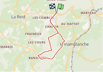
Ruta Senderismo de 6 km a descubrir en Valonia, Lieja, Theux. Esta ruta ha sido propuesta por pierreh01.
Descripción
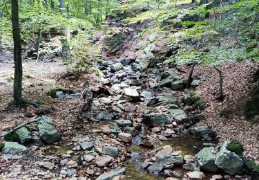
Lundi 25 novembre 2024 : Balade hebdomadaire des "BIOS".
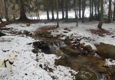
Quelques 12 irréductibles "BIOS" (3 femmes et 9 hommes) n'ont pas hésité à braver les conditions météorologiques pour accompagner notre guide du jour, André.
C'est sous une pluie fine que nous avons effectué la plus grande partie de cette balade en empruntant rues, et beaucoup de sentiers forestiers généralement boueux à très boueux, quand ils n'étaient pas partiellement inondés.
Les sentiers campagnards empruntés étaient plus agréables à fouler.
Pendant le dernier kilomètre, nous avons encaissé une grosse averse avant de rejoindre les voitures.
Distance de 6 Km, mesurée avec Sity Trail.
Localización
Comentarios
Excursiones cerca
![Excursión Senderismo Theux - RB-Lg-24_La-Reid_via-racc-1 - Photo](https://media.geolcdn.com/t/375/260/ext.jpg?maxdim=2&url=https%3A%2F%2Fservices.sitytrail.com%2FGeolivesWS%2FDownloadMedia.ashx%3FTrailID%3D400924%26Media%3De46f0d15-4872-47d2-9c6f-9e812d51cefb.jpg)
![Senderismo Senderismo](https://static1.geolcdn.com/sitytour/trail-icons/101.png)
Senderismo
![](/images/other/stat-length.png)
![](https://static1.geolcdn.com/siteimages/upload/files/16400158638029165_repeat_loop_refresh_sync_direction_icon.png)
![Excursión Senderismo Theux - RB-Lg-24_La-Reid - Photo](https://media.geolcdn.com/t/375/260/ext.jpg?maxdim=2&url=https%3A%2F%2Fservices.sitytrail.com%2FGeolivesWS%2FDownloadMedia.ashx%3FTrailID%3D400922%26Media%3De46f0d15-4872-47d2-9c6f-9e812d51cefb.jpg)
![Senderismo Senderismo](https://static1.geolcdn.com/sitytour/trail-icons/101.png)
![Excursión Senderismo Aywaille - Petite remontée du Ninglispo - Photo](https://media.geolcdn.com/t/375/260/ext.jpg?maxdim=2&url=https%3A%2F%2Fservices.sitytrail.com%2FGeolivesWS%2FDownloadMedia.ashx%3FTrailID%3D536482%26Media%3D20160311161707.jpg)
![Senderismo Senderismo](https://static1.geolcdn.com/sitytour/trail-icons/101.png)
Senderismo
![](/images/other/stat-length.png)
![](https://static1.geolcdn.com/siteimages/upload/files/16400158638029165_repeat_loop_refresh_sync_direction_icon.png)
![Excursión Senderismo Theux - RF-Lg-08_Franchimont_Grande-boucle - Photo](https://media.geolcdn.com/t/375/260/ext.jpg?maxdim=2&url=https%3A%2F%2Fstatic1.geolcdn.com%2Fsiteimages%2Fupload%2Ffiles%2F1553511878bg_sport_marche.png)
![Senderismo Senderismo](https://static1.geolcdn.com/sitytour/trail-icons/101.png)
Senderismo
![](/images/other/stat-length.png)
![](https://static1.geolcdn.com/siteimages/upload/files/16400158638029165_repeat_loop_refresh_sync_direction_icon.png)
![Excursión Senderismo Spa - La Géronstère - Photo](https://media.geolcdn.com/t/375/260/8ca868a1-41f5-42f7-8949-cf692aad46aa.jpg&format=jpg&maxdim=2)
![Senderismo Senderismo](https://static1.geolcdn.com/sitytour/trail-icons/101.png)
![Excursión Bicicleta Spa - SPA - Tour des Sources en VAE - Photo](https://media.geolcdn.com/t/375/260/7c7fabc0-d10b-47d5-9c1b-3ff9eef1ffc8.jpg&format=jpg&maxdim=2)
![Bicicleta Bicicleta](https://static1.geolcdn.com/sitytour/trail-icons/200.png)
Bicicleta
![](/images/other/stat-length.png)
![](https://static1.geolcdn.com/siteimages/upload/files/16400158638029165_repeat_loop_refresh_sync_direction_icon.png)
![Excursión Bici eléctrica Spa - SPA - Patrimoine Thermal en VAE - Photo](https://media.geolcdn.com/t/375/260/ee0abd42-ac04-4732-893c-f88ca135e7d8.jpg&format=jpg&maxdim=2)
![Bici eléctrica Bici eléctrica](https://static1.geolcdn.com/sitytour/trail-icons/205.png)
Bici eléctrica
![](/images/other/stat-length.png)
![](https://static1.geolcdn.com/siteimages/upload/files/16400158638029165_repeat_loop_refresh_sync_direction_icon.png)
![Excursión Senderismo Spa - La promenade des artistes (7,6km) - Photo](https://media.geolcdn.com/t/375/260/3dde1b93-3102-4ae4-89c2-bf0ec680b01c.jpg&format=jpg&maxdim=2)
![Senderismo Senderismo](https://static1.geolcdn.com/sitytour/trail-icons/101.png)
Senderismo
![](/images/other/stat-length.png)
![](https://static1.geolcdn.com/siteimages/upload/files/16400158638029165_repeat_loop_refresh_sync_direction_icon.png)
![Senderismo Senderismo](https://static1.geolcdn.com/sitytour/trail-icons/101.png)
Senderismo
![](/images/other/stat-length.png)
![](https://static1.geolcdn.com/siteimages/upload/files/16400158638029165_repeat_loop_refresh_sync_direction_icon.png)