![](/images/other/stat-length.png)
![Excursión Cicloturismo Orpierre - 101124 Tour de la Méouge - Photo](https://media.geolcdn.com/t/1900/400/ext.pjpeg?maxdim=2&url=https%3A%2F%2Fstatic1.geolcdn.com%2Fsiteimages%2Fupload%2Ffiles%2F1524743154velo.jpg)
101124 Tour de la Méouge
mzonzon05
Usuario
![Longitud](/images/other/stat-length.png)
![Altitud máxima](https://static1.geolcdn.com/siteimages/upload/files/1508320355ic_sort_altitude_max_24dp.png)
![Desnivel positivo](https://static1.geolcdn.com/siteimages/upload/files/1508320355ic_sort_den_pos_24dp.png)
![Km-Effort](/images/other/stat-length.png)
![Altitud mínima](https://static1.geolcdn.com/siteimages/upload/files/1508320355ic_sort_altitude_min_24dp.png)
![Desnivel negativo](https://static1.geolcdn.com/siteimages/upload/files/1508320355ic_sort_den_neg_24dp.png)
![Boucle](https://static1.geolcdn.com/siteimages/upload/files/16400158638029165_repeat_loop_refresh_sync_direction_icon.png)
![Cicloturismo](https://static1.geolcdn.com/sitytour/trail-icons/204.png)
6h12
Dificultad : Medio
![Escanee este código QR para abrir la excursión en la aplicación SityTrail](https://capi.geolives.com/qq0zvz2zws4bq2lad0pu/sitytour/trails/4259421/qr.png?size=200)
Aplicación GPS de excursión GRATIS
A propósito
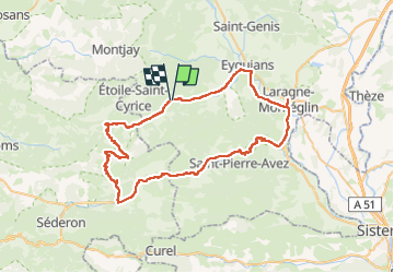
Ruta Cicloturismo de 70 km a descubrir en Provenza-Alpes-Costa Azul, Altos Alpes, Orpierre. Esta ruta ha sido propuesta por mzonzon05.
Descripción
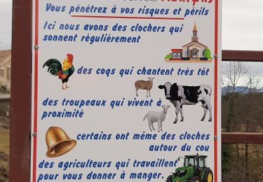
Magnifique tour de vélo à faire hors saison. Ici à l'automne la montée du col Saint Jean est facile et solitaire avec de jolis points de vue sur le Dévoluy, le détour par Izon la Bruisse est splendide avec ses crêtes et ses pitons rocheux. Calme et majestueux.
La descente de la Méouge est évidemment divine, surtout sans la foule estivale ! Quoi que nous n'étions pas seuls aux points de vue classiques !
Enfin la route de Saléon est calme et ondulée, parfaite pour finir de nous achever ! Nous avons eu la chance de revenir sur Orpierre avec les derniers rayons du soleil malgré notre départ honteusement tardif !
Bref, à faire ou refaire en se laissant envoûter.
Localización
Comentarios
Excursiones cerca
![Excursión Senderismo Sainte-Colombe - ORPIERRES . DEPART CHEVALET . BEYNAVES . MONTAGNE SAINT MICHEL . AR N - Photo](https://media.geolcdn.com/t/375/260/20a96408-d155-4851-ac8c-c625bffcf962.jpg&format=jpg&maxdim=2)
![Senderismo Senderismo](https://static1.geolcdn.com/sitytour/trail-icons/101.png)
Senderismo
![](/images/other/stat-length.png)
![](https://static1.geolcdn.com/siteimages/upload/files/16400158638029165_repeat_loop_refresh_sync_direction_icon.png)
![Excursión Senderismo Sainte-Colombe - SAINTE COLOMBE , les Bègues, autour des versants du Céans o l - Photo](https://media.geolcdn.com/t/375/260/32ebd511-d9af-4e86-9fe3-3ac4fc66c4b2.jpg&format=jpg&maxdim=2)
![Senderismo Senderismo](https://static1.geolcdn.com/sitytour/trail-icons/101.png)
Senderismo
![](/images/other/stat-length.png)
![](https://static1.geolcdn.com/siteimages/upload/files/16400158638029165_repeat_loop_refresh_sync_direction_icon.png)
![Excursión Senderismo Sainte-Colombe - SAINTE COLOMBE . 05 . Pas de Sainte Colombe o m s - Photo](https://media.geolcdn.com/t/375/260/81962515-6c25-41a2-9c57-59c34af424da.jpg&format=jpg&maxdim=2)
![Senderismo Senderismo](https://static1.geolcdn.com/sitytour/trail-icons/101.png)
Senderismo
![](/images/other/stat-length.png)
![](https://static1.geolcdn.com/siteimages/upload/files/16400158638029165_repeat_loop_refresh_sync_direction_icon.png)
![Excursión Senderismo Trescléoux - TRESCLEOUX Les granges de la montagne o s - Photo](https://media.geolcdn.com/t/375/260/d4139a1d-235b-4693-b7cd-01eb7b25235b.jpg&format=jpg&maxdim=2)
![Senderismo Senderismo](https://static1.geolcdn.com/sitytour/trail-icons/101.png)
Senderismo
![](/images/other/stat-length.png)
![](https://static1.geolcdn.com/siteimages/upload/files/16400158638029165_repeat_loop_refresh_sync_direction_icon.png)
![Excursión Senderismo Sainte-Colombe - st colombe la](https://media.geolcdn.com/t/375/260/ext.jpg?maxdim=2&url=https%3A%2F%2Fservices.sitytrail.com%2FGeolivesWS%2FDownloadMedia.ashx%3FTrailID%3D791502%26Media%3Dfix__20160430095733.jpg)
![Senderismo Senderismo](https://static1.geolcdn.com/sitytour/trail-icons/101.png)
Senderismo
![](/images/other/stat-length.png)
![](https://static1.geolcdn.com/siteimages/upload/files/16400158638029165_repeat_loop_refresh_sync_direction_icon.png)
![Excursión Senderismo Orpierre - rocher st Michel - Photo](https://media.geolcdn.com/t/375/260/ext.jpg?maxdim=2&url=https%3A%2F%2Fservices.sitytrail.com%2FGeolivesWS%2FDownloadMedia.ashx%3FTrailID%3D569402%26Media%3Dfix__20160425114304.jpg)
![Senderismo Senderismo](https://static1.geolcdn.com/sitytour/trail-icons/101.png)
Senderismo
![](/images/other/stat-length.png)
![](https://static1.geolcdn.com/siteimages/upload/files/16400158638029165_repeat_loop_refresh_sync_direction_icon.png)
![Excursión Senderismo Sainte-Colombe - catoyes - Photo](https://media.geolcdn.com/t/375/260/ac87557a-0021-44d7-a91c-c330dd7837f6.jpg&format=jpg&maxdim=2)
![Senderismo Senderismo](https://static1.geolcdn.com/sitytour/trail-icons/101.png)
Senderismo
![](/images/other/stat-length.png)
![](https://static1.geolcdn.com/siteimages/upload/files/16400158638029165_repeat_loop_refresh_sync_direction_icon.png)
![Excursión Senderismo Trescléoux - TRESCLEOUX .GRANGES DE CHANOUSSE O - Photo](https://media.geolcdn.com/t/375/260/53f4cc1e-2c32-49c3-a4d1-738f80599446.jpg&format=jpg&maxdim=2)
![Senderismo Senderismo](https://static1.geolcdn.com/sitytour/trail-icons/101.png)
Senderismo
![](/images/other/stat-length.png)
![](https://static1.geolcdn.com/siteimages/upload/files/16400158638029165_repeat_loop_refresh_sync_direction_icon.png)
![Excursión Senderismo Sainte-Colombe - 100423 Plan de Cuques - Photo](https://media.geolcdn.com/t/375/260/81f5bad3-8982-4a8b-b73b-e72d77fc0e67.jpg&format=jpg&maxdim=2)
![Senderismo Senderismo](https://static1.geolcdn.com/sitytour/trail-icons/101.png)
Senderismo
![](/images/other/stat-length.png)
![](https://static1.geolcdn.com/siteimages/upload/files/16400158638029165_repeat_loop_refresh_sync_direction_icon.png)