![](/images/other/stat-length.png)
![Excursión Senderismo Guizengeard - LACS BLEUS de GUIZENGEARDE - Photo](https://media.geolcdn.com/t/1900/400/9c37018d-5723-46ff-b133-18aac742d8e4.jpg&format=pjpeg&maxdim=2)
LACS BLEUS de GUIZENGEARDE
Miclm
Usuario
![Longitud](/images/other/stat-length.png)
![Altitud máxima](https://static1.geolcdn.com/siteimages/upload/files/1508320355ic_sort_altitude_max_24dp.png)
![Desnivel positivo](https://static1.geolcdn.com/siteimages/upload/files/1508320355ic_sort_den_pos_24dp.png)
![Km-Effort](/images/other/stat-length.png)
![Altitud mínima](https://static1.geolcdn.com/siteimages/upload/files/1508320355ic_sort_altitude_min_24dp.png)
![Desnivel negativo](https://static1.geolcdn.com/siteimages/upload/files/1508320355ic_sort_den_neg_24dp.png)
![Boucle](https://static1.geolcdn.com/siteimages/upload/files/16400158638029165_repeat_loop_refresh_sync_direction_icon.png)
![Senderismo](https://static1.geolcdn.com/sitytour/trail-icons/101.png)
1h22
Dificultad : Medio
![Escanee este código QR para abrir la excursión en la aplicación SityTrail](https://capi.geolives.com/qq0zvz2zws4bq2lad0pu/sitytour/trails/4249709/qr.png?size=200)
Aplicación GPS de excursión GRATIS
A propósito
Ruta Senderismo de 4,8 km a descubrir en Nueva Aquitania, Charente, Guizengeard. Esta ruta ha sido propuesta por Miclm.
Descripción
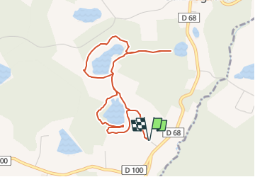
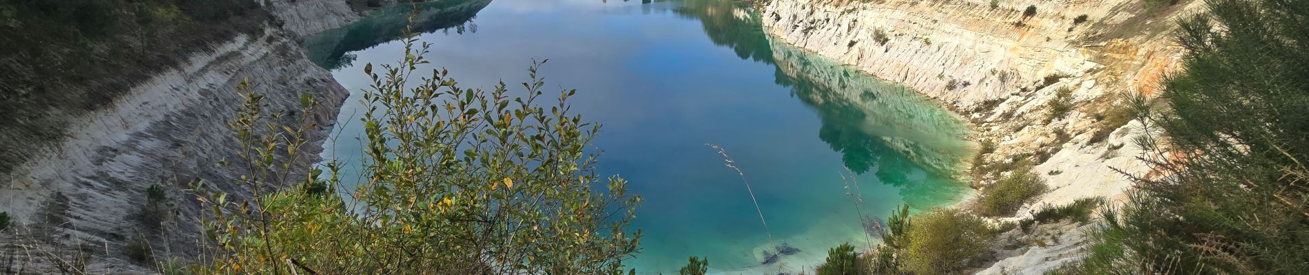
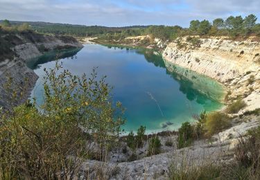
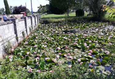
Balade familiale de 4.9 km sans difficulté permettant de voir 3 Lacs Bleus . Suivre le tracé qui sort du sentier balisé mais facilement repérable et qui fait un aller-retour pourvoir le lac le plus bleu, il est d'un bleu intense au point que lorsque l'on regarde la photo cela donne l'impression d'être un montage mais la photo est bien réelle sans aucune correction ni filtre.
Pour les amateurs de coucher de soleil il y a de belles photos a faire.
A l’origine, le site était une carrière d’argile blanche (appelée Kaolin) qui, lors de son abandon, s’est gorgée d’eau de pluie.
Attention ne pas franchir les barrières :
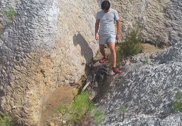
• Les bords des falaises sont très friables, leur hauteur varie de 0 à une à une quinzaine de m. mais les lacs ont une profondeur pouvant atteindre 40 à 50m.
• Il est interdit de s’y baigner, l’instabilité des sols sur fond d’argile glissante rend tout sauvetage pratiquement impossible
• protection de la faune et la flore (amendes jusqu’à 750 €)
Pour aller au lac très bleu cité plus haut,
Il n’y a pas d’interdiction, il faut simplement sortir du sentier balisé sur environ 400m et découvrir cette beauté.
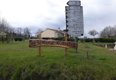
Le départ se fait du parking de l’église
Un autre départ depuis le parking de la Mairie Chez Thomas
Pour les camping-caristes il est possible de dormir sur ces 2 parkings ( nous avons dormis sur l’immense parking ombragé de la Mairie)
Bonne Balade
Localización
Comentarios
Excursiones cerca
![Excursión Senderismo Guizengeard - LACS BLEUS GUIZENGEARD depuis le Parking de la Mairie - Photo](https://media.geolcdn.com/t/375/260/23f5abc0-6ffa-4982-b7fb-900d7926100c.jpg&format=jpg&maxdim=2)
![Senderismo Senderismo](https://static1.geolcdn.com/sitytour/trail-icons/101.png)
Senderismo
![](/images/other/stat-length.png)
![](https://static1.geolcdn.com/siteimages/upload/files/16400158638029165_repeat_loop_refresh_sync_direction_icon.png)
![Excursión Senderismo Guizengeard - guizengeard 03 avril 2018 - Photo](https://media.geolcdn.com/t/375/260/ext.jpg?maxdim=2&url=https%3A%2F%2Fservices.sitytrail.com%2FGeolivesWS%2FDownloadMedia.ashx%3FTrailID%3D935968%26Media%3Dfix__20180403155820.jpg)
![Senderismo Senderismo](https://static1.geolcdn.com/sitytour/trail-icons/101.png)
Senderismo
![](/images/other/stat-length.png)
![](https://static1.geolcdn.com/siteimages/upload/files/16400158638029165_repeat_loop_refresh_sync_direction_icon.png)
![Excursión Senderismo Boisbreteau - Le circuit des cervidés - Boisbreteau - Photo](https://media.geolcdn.com/t/375/260/ext.jpg?maxdim=2&url=https%3A%2F%2Fservices.sitytrail.com%2FGeolivesWS%2FDownloadMedia.ashx%3FTrailID%3D105965%26Media%3D10057_4.jpg)
![Senderismo Senderismo](https://static1.geolcdn.com/sitytour/trail-icons/101.png)
Senderismo
![](/images/other/stat-length.png)
![](https://static1.geolcdn.com/siteimages/upload/files/16400158638029165_repeat_loop_refresh_sync_direction_icon.png)
![Excursión Senderismo Guizengeard - guizengard - Photo](https://media.geolcdn.com/t/375/260/cd182967-7bfe-4900-b475-cc9397124e6a.jpg&format=jpg&maxdim=2)
![Senderismo Senderismo](https://static1.geolcdn.com/sitytour/trail-icons/101.png)
Senderismo
![](/images/other/stat-length.png)
![](https://static1.geolcdn.com/siteimages/upload/files/16400158638029165_repeat_loop_refresh_sync_direction_icon.png)
![Excursión Senderismo Brossac - étang vallier brossac - Photo](https://media.geolcdn.com/t/375/260/b34462fd-fc95-4c14-8855-d923b478bf00.jpg&format=jpg&maxdim=2)
![Senderismo Senderismo](https://static1.geolcdn.com/sitytour/trail-icons/101.png)
Senderismo
![](/images/other/stat-length.png)
![](https://static1.geolcdn.com/siteimages/upload/files/16400158638029165_repeat_loop_refresh_sync_direction_icon.png)
![Excursión Senderismo Guizengeard - guizengeard - Photo](https://media.geolcdn.com/t/375/260/ext.jpg?maxdim=2&url=https%3A%2F%2Fstatic1.geolcdn.com%2Fsiteimages%2Fupload%2Ffiles%2F1553511878bg_sport_marche.png)
![Senderismo Senderismo](https://static1.geolcdn.com/sitytour/trail-icons/101.png)
Senderismo
![](/images/other/stat-length.png)
![](https://static1.geolcdn.com/siteimages/upload/files/16400158638029165_repeat_loop_refresh_sync_direction_icon.png)
![Excursión Senderismo Guizengeard - ballade aux lacs bleus - Photo](https://media.geolcdn.com/t/375/260/ext.jpg?maxdim=2&url=https%3A%2F%2Fstatic1.geolcdn.com%2Fsiteimages%2Fupload%2Ffiles%2F1553511878bg_sport_marche.png)
![Senderismo Senderismo](https://static1.geolcdn.com/sitytour/trail-icons/101.png)
Senderismo
![](/images/other/stat-length.png)
![](https://static1.geolcdn.com/siteimages/upload/files/16400158638029165_repeat_loop_refresh_sync_direction_icon.png)
![Excursión Senderismo Guizengeard - Guizengeard - Photo](https://media.geolcdn.com/t/375/260/ext.jpg?maxdim=2&url=https%3A%2F%2Fstatic1.geolcdn.com%2Fsiteimages%2Fupload%2Ffiles%2F1553511878bg_sport_marche.png)
![Senderismo Senderismo](https://static1.geolcdn.com/sitytour/trail-icons/101.png)
Senderismo
![](/images/other/stat-length.png)
![](https://static1.geolcdn.com/siteimages/upload/files/16400158638029165_repeat_loop_refresh_sync_direction_icon.png)
![Excursión Senderismo Saint-Vallier - Boresse - Photo](https://media.geolcdn.com/t/375/260/ext.jpg?maxdim=2&url=https%3A%2F%2Fstatic1.geolcdn.com%2Fsiteimages%2Fupload%2Ffiles%2F1553511878bg_sport_marche.png)
![Senderismo Senderismo](https://static1.geolcdn.com/sitytour/trail-icons/101.png)
Senderismo
![](/images/other/stat-length.png)
![](https://static1.geolcdn.com/siteimages/upload/files/16400158638029165_repeat_loop_refresh_sync_direction_icon.png)