![](/images/other/stat-length.png)
![Excursión Senderismo Cauterets - Lacs et col d'Estibe Aute - Photo](https://media.geolcdn.com/t/1900/400/ext.pjpeg?maxdim=2&url=https%3A%2F%2Fstatic1.geolcdn.com%2Fsiteimages%2Fupload%2Ffiles%2F1553511878bg_sport_marche.png)
Lacs et col d'Estibe Aute
loicthev
Usuario
![Longitud](/images/other/stat-length.png)
Longitud
17,3 km
![Altitud máxima](https://static1.geolcdn.com/siteimages/upload/files/1508320355ic_sort_altitude_max_24dp.png)
Altitud máxima
2644 m
![Desnivel positivo](https://static1.geolcdn.com/siteimages/upload/files/1508320355ic_sort_den_pos_24dp.png)
Desnivel positivo
1298 m
![Km-Effort](/images/other/stat-length.png)
Km-Effort
35 km
![Altitud mínima](https://static1.geolcdn.com/siteimages/upload/files/1508320355ic_sort_altitude_min_24dp.png)
Altitud mínima
1369 m
![Desnivel negativo](https://static1.geolcdn.com/siteimages/upload/files/1508320355ic_sort_den_neg_24dp.png)
Desnivel negativo
1298 m
![Boucle](https://static1.geolcdn.com/siteimages/upload/files/16400158638029165_repeat_loop_refresh_sync_direction_icon.png)
Boucle
Sí
Fecha de creación :
2024-10-31 07:44:52.151
Última modificación :
2024-10-31 17:32:20.773
![Senderismo](https://static1.geolcdn.com/sitytour/trail-icons/101.png)
5h26
Dificultad : Medio
![Escanee este código QR para abrir la excursión en la aplicación SityTrail](https://capi.geolives.com/qq0zvz2zws4bq2lad0pu/sitytour/trails/4242852/qr.png?size=200)
Aplicación GPS de excursión GRATIS
A propósito
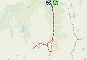
Ruta Senderismo de 17,3 km a descubrir en Occitania, Altos-Pirineos, Cauterets. Esta ruta ha sido propuesta por loicthev.
Descripción
rando vallée du Lutour
La Fruitière > lacs et col d'Estibe Aute > lac d'Estom > La Fruitière
31/10/2024
Alexandre
Localización
País:
France
Región :
Occitania
Departamento/provincia :
Altos-Pirineos
Municipio :
Cauterets
Localidad:
Unknown
Salida:(Dec)
Salida:(UTM)
737104 ; 4748587 (30T) N.
Comentarios
Excursiones cerca
![Excursión Senderismo Cauterets - Lac d'Estom - Photo](https://media.geolcdn.com/t/375/260/7676879f-23b9-4413-a840-ce71b34895f9.jpg&format=jpg&maxdim=2)
![Senderismo Senderismo](https://static1.geolcdn.com/sitytour/trail-icons/101.png)
Lac d'Estom
Senderismo
Medio
(1)
Cauterets,
Occitania,
Altos-Pirineos,
France
![](/images/other/stat-length.png)
11,4 km | 17,5 km-effort
3h 30min
![](https://static1.geolcdn.com/siteimages/upload/files/16400158638029165_repeat_loop_refresh_sync_direction_icon.png)
Sí
![Excursión Senderismo Sazos - Lac de Lagües - Photo](https://media.geolcdn.com/t/375/260/ext.jpg?maxdim=2&url=https%3A%2F%2Fservices.sitytrail.com%2FGeolivesWS%2FDownloadMedia.ashx%3FTrailID%3D581008%26Media%3Dfix__20160607163041.jpg)
![Senderismo Senderismo](https://static1.geolcdn.com/sitytour/trail-icons/101.png)
Lac de Lagües
Senderismo
Medio
(2)
Sazos,
Occitania,
Altos-Pirineos,
France
![](/images/other/stat-length.png)
9,1 km | 18,9 km-effort
5h 14min
![](https://static1.geolcdn.com/siteimages/upload/files/16400158638029165_repeat_loop_refresh_sync_direction_icon.png)
Sí
![Excursión Senderismo Cauterets - contrefort de Cauterets - Photo](https://media.geolcdn.com/t/375/260/ext.jpg?maxdim=2&url=https%3A%2F%2Fservices.sitytrail.com%2FGeolivesWS%2FDownloadMedia.ashx%3FTrailID%3D397347%26Media%3Dfix__20150318161219.jpg)
![Senderismo Senderismo](https://static1.geolcdn.com/sitytour/trail-icons/101.png)
contrefort de Cauterets
Senderismo
Medio
(1)
Cauterets,
Occitania,
Altos-Pirineos,
France
![](/images/other/stat-length.png)
13,7 km | 21 km-effort
4h 21min
![](https://static1.geolcdn.com/siteimages/upload/files/16400158638029165_repeat_loop_refresh_sync_direction_icon.png)
Sí
![Excursión Senderismo Grust - PIC DE VISCOS - Photo](https://media.geolcdn.com/t/375/260/ext.jpg?maxdim=2&url=https%3A%2F%2Fservices.sitytrail.com%2FGeolivesWS%2FDownloadMedia.ashx%3FTrailID%3D330339%26Media%3Dfix__20140802123956.jpg)
![Senderismo Senderismo](https://static1.geolcdn.com/sitytour/trail-icons/101.png)
PIC DE VISCOS
Senderismo
Medio
(1)
Grust,
Occitania,
Altos-Pirineos,
France
![](/images/other/stat-length.png)
10,5 km | 18,4 km-effort
4h 7min
![](https://static1.geolcdn.com/siteimages/upload/files/16400158638029165_repeat_loop_refresh_sync_direction_icon.png)
Sí
![Excursión Senderismo Cauterets - promenade Russell - Photo](https://media.geolcdn.com/t/375/260/ext.jpg?maxdim=2&url=https%3A%2F%2Fservices.sitytrail.com%2FGeolivesWS%2FDownloadMedia.ashx%3FTrailID%3D1020841%26Media%3Dfix__20180812100734.jpg)
![Senderismo Senderismo](https://static1.geolcdn.com/sitytour/trail-icons/101.png)
promenade Russell
Senderismo
Muy fácil
(1)
Cauterets,
Occitania,
Altos-Pirineos,
France
![](/images/other/stat-length.png)
11,9 km | 21 km-effort
5h 46min
![](https://static1.geolcdn.com/siteimages/upload/files/16400158638029165_repeat_loop_refresh_sync_direction_icon.png)
Sí
![Excursión Senderismo Cauterets - Chemin des cascades - Photo](https://media.geolcdn.com/t/375/260/ext.jpg?maxdim=2&url=https%3A%2F%2Fservices.sitytrail.com%2FGeolivesWS%2FDownloadMedia.ashx%3FTrailID%3D807444%26Media%3Dfix__20170811162357.jpg)
![Senderismo Senderismo](https://static1.geolcdn.com/sitytour/trail-icons/101.png)
Chemin des cascades
Senderismo
Fácil
(1)
Cauterets,
Occitania,
Altos-Pirineos,
France
![](/images/other/stat-length.png)
8 km | 12,6 km-effort
2h 30min
![](https://static1.geolcdn.com/siteimages/upload/files/16400158638029165_repeat_loop_refresh_sync_direction_icon.png)
No
![Excursión Senderismo Cauterets - 2022-12-31 Marche Refuge du Clot vers Refuge Wallon - Photo](https://media.geolcdn.com/t/375/260/b3b3e7b5-b7c0-4d24-bf3e-ca9e2bad9ac8.jpg&format=jpg&maxdim=2)
![Senderismo Senderismo](https://static1.geolcdn.com/sitytour/trail-icons/101.png)
2022-12-31 Marche Refuge du Clot vers Refuge Wallon
Senderismo
Difícil
Cauterets,
Occitania,
Altos-Pirineos,
France
![](/images/other/stat-length.png)
17,3 km | 34 km-effort
7h 46min
![](https://static1.geolcdn.com/siteimages/upload/files/16400158638029165_repeat_loop_refresh_sync_direction_icon.png)
No
![Excursión Senderismo Cauterets - CAUTERETS Le chemin des pères G3 le 14/10/2022](https://media.geolcdn.com/t/375/260/15fc21f1-76b1-44b0-aa82-d95bc69ee2d3.jpg&format=jpg&maxdim=2)
![Senderismo Senderismo](https://static1.geolcdn.com/sitytour/trail-icons/101.png)
CAUTERETS Le chemin des pères G3 le 14/10/2022 "3423761"
Senderismo
Medio
Cauterets,
Occitania,
Altos-Pirineos,
France
![](/images/other/stat-length.png)
9,4 km | 15,3 km-effort
3h 5min
![](https://static1.geolcdn.com/siteimages/upload/files/16400158638029165_repeat_loop_refresh_sync_direction_icon.png)
Sí
![Excursión Senderismo Cauterets - Pic d'Estibe Aute - Photo](https://media.geolcdn.com/t/375/260/ext.jpg?maxdim=2&url=https%3A%2F%2Fstatic1.geolcdn.com%2Fsiteimages%2Fupload%2Ffiles%2F1553511878bg_sport_marche.png)
![Senderismo Senderismo](https://static1.geolcdn.com/sitytour/trail-icons/101.png)
Pic d'Estibe Aute
Senderismo
Muy difícil
(1)
Cauterets,
Occitania,
Altos-Pirineos,
France
![](/images/other/stat-length.png)
17,2 km | 36 km-effort
7h 0min
![](https://static1.geolcdn.com/siteimages/upload/files/16400158638029165_repeat_loop_refresh_sync_direction_icon.png)
Sí