![](/images/other/stat-length.png)
![Excursión Senderismo Saint-François-Longchamp - Montgelaffrey Lac de la Lechère Montgelaffrey - Photo](https://media.geolcdn.com/t/1900/400/ext.pjpeg?maxdim=2&url=https%3A%2F%2Fstatic1.geolcdn.com%2Fsiteimages%2Fupload%2Ffiles%2F1553511878bg_sport_marche.png)
Montgelaffrey Lac de la Lechère Montgelaffrey
Delahalle
Usuario
![Longitud](/images/other/stat-length.png)
![Altitud máxima](https://static1.geolcdn.com/siteimages/upload/files/1508320355ic_sort_altitude_max_24dp.png)
![Desnivel positivo](https://static1.geolcdn.com/siteimages/upload/files/1508320355ic_sort_den_pos_24dp.png)
![Km-Effort](/images/other/stat-length.png)
![Altitud mínima](https://static1.geolcdn.com/siteimages/upload/files/1508320355ic_sort_altitude_min_24dp.png)
![Desnivel negativo](https://static1.geolcdn.com/siteimages/upload/files/1508320355ic_sort_den_neg_24dp.png)
![Boucle](https://static1.geolcdn.com/siteimages/upload/files/16400158638029165_repeat_loop_refresh_sync_direction_icon.png)
![Senderismo](https://static1.geolcdn.com/sitytour/trail-icons/101.png)
3h30
Dificultad : Medio
![Escanee este código QR para abrir la excursión en la aplicación SityTrail](https://capi.geolives.com/qq0zvz2zws4bq2lad0pu/sitytour/trails/4240647/qr.png?size=200)
Aplicación GPS de excursión GRATIS
A propósito
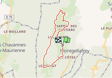
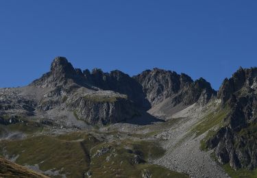
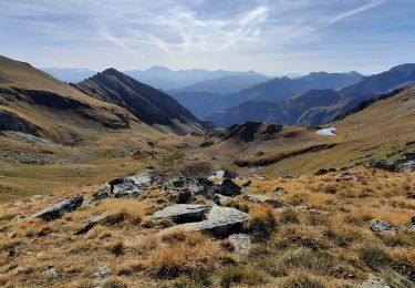
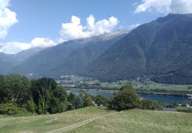
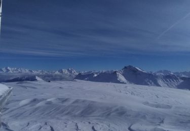
Ruta Senderismo de 7,2 km a descubrir en Auvergne-Rhône-Alpes, Saboya, Saint-François-Longchamp. Esta ruta ha sido propuesta por Delahalle.
Descripción
Très belle randonnée, pas trop longue. Passage par de petits hameaux très isolés. Nombreuses vues panoramiques en particulier sur les Aiguilles d'Arves, le pic du Frêne, les Grands Moulins, le col de Chaussy et toute la vallée qui monte sur Saint François Longchamp. Possibilité de boire un verre ou se restaurer au refuge de la Léchère, ouvert 10 mois sur 12 (fermé en novembre et jusqu'au 20 décembre environ).
Localización
Comentarios
Excursiones cerca
![Excursión A pie Saint-François-Longchamp - Itinéraire de trail vert Le Sapin - Photo](https://media.geolcdn.com/t/375/260/75d11713-5eaa-4347-a63a-24768045895b.jpeg&format=jpg&maxdim=2)
![A pie A pie](https://static1.geolcdn.com/sitytour/trail-icons/100.png)
A pie
![](/images/other/stat-length.png)
![](https://static1.geolcdn.com/siteimages/upload/files/16400158638029165_repeat_loop_refresh_sync_direction_icon.png)
![Excursión A pie Saint-François-Longchamp - Itinéraire de trail bleu Le Taimonain - Photo](https://media.geolcdn.com/t/375/260/426c19c5-a85d-490e-9892-908e58951b2e.jpeg&format=jpg&maxdim=2)
![A pie A pie](https://static1.geolcdn.com/sitytour/trail-icons/100.png)
A pie
![](/images/other/stat-length.png)
![](https://static1.geolcdn.com/siteimages/upload/files/16400158638029165_repeat_loop_refresh_sync_direction_icon.png)
![Excursión A pie Saint-François-Longchamp - Itinéraire de trail noir Kilomètre vertical du Cheval Noir - Photo](https://media.geolcdn.com/t/375/260/e402ee96-fef3-4cbe-889a-479ec7063a83.jpeg&format=jpg&maxdim=2)
![A pie A pie](https://static1.geolcdn.com/sitytour/trail-icons/100.png)
A pie
![](/images/other/stat-length.png)
![](https://static1.geolcdn.com/siteimages/upload/files/16400158638029165_repeat_loop_refresh_sync_direction_icon.png)
![Excursión A pie Saint-François-Longchamp - Itinéraire de trail rouge Le Colombin - Photo](https://media.geolcdn.com/t/375/260/7765f6d2-c209-44a9-976d-d89f41e09634.jpeg&format=jpg&maxdim=2)
![A pie A pie](https://static1.geolcdn.com/sitytour/trail-icons/100.png)
A pie
![](/images/other/stat-length.png)
![](https://static1.geolcdn.com/siteimages/upload/files/16400158638029165_repeat_loop_refresh_sync_direction_icon.png)
![Excursión Esquí de fondo Saint-Rémy-de-Maurienne - col de la Valette - Photo](https://media.geolcdn.com/t/375/260/57a078c9-9933-40f7-b6a3-6465f4504a2e.jpg&format=jpg&maxdim=2)
![Esquí de fondo Esquí de fondo](https://static1.geolcdn.com/sitytour/trail-icons/503.png)
Esquí de fondo
![](/images/other/stat-length.png)
![](https://static1.geolcdn.com/siteimages/upload/files/16400158638029165_repeat_loop_refresh_sync_direction_icon.png)
![Excursión Senderismo Saint-François-Longchamp - rando 4 - Photo](https://media.geolcdn.com/t/375/260/ext.jpg?maxdim=2&url=https%3A%2F%2Fstatic1.geolcdn.com%2Fsiteimages%2Fupload%2Ffiles%2F1553511878bg_sport_marche.png)
![Senderismo Senderismo](https://static1.geolcdn.com/sitytour/trail-icons/101.png)
Senderismo
![](/images/other/stat-length.png)
![](https://static1.geolcdn.com/siteimages/upload/files/16400158638029165_repeat_loop_refresh_sync_direction_icon.png)
![Excursión Senderismo La Léchère - Le Cheval Noir - Photo](https://media.geolcdn.com/t/375/260/788ca868-0447-42b1-943c-c45c9c1958b3.jpg&format=jpg&maxdim=2)
![Senderismo Senderismo](https://static1.geolcdn.com/sitytour/trail-icons/101.png)
Senderismo
![](/images/other/stat-length.png)
![](https://static1.geolcdn.com/siteimages/upload/files/16400158638029165_repeat_loop_refresh_sync_direction_icon.png)
![Excursión Bici de carretera Saint-Rémy-de-Maurienne - col du gd Cucheron - Photo](https://media.geolcdn.com/t/375/260/ba655a14-1a6f-40db-b073-4d373db0a54f.jpg&format=jpg&maxdim=2)
![Bici de carretera Bici de carretera](https://static1.geolcdn.com/sitytour/trail-icons/201.png)
Bici de carretera
![](/images/other/stat-length.png)
![](https://static1.geolcdn.com/siteimages/upload/files/16400158638029165_repeat_loop_refresh_sync_direction_icon.png)
![Excursión Esquí de fondo Saint-François-Longchamp - sous le gros villan - Photo](https://media.geolcdn.com/t/375/260/07c709e7-ace5-44ae-9319-d2506d27b2af.jpg&format=jpg&maxdim=2)
![Esquí de fondo Esquí de fondo](https://static1.geolcdn.com/sitytour/trail-icons/503.png)
Esquí de fondo
![](/images/other/stat-length.png)
![](https://static1.geolcdn.com/siteimages/upload/files/16400158638029165_repeat_loop_refresh_sync_direction_icon.png)