![](/images/other/stat-length.png)
![Excursión Paseo ecuestre Dambach-la-Ville - dambach ortenbourg - Photo](https://media.geolcdn.com/t/1900/400/ext.pjpeg?maxdim=2&url=https%3A%2F%2Fstatic1.geolcdn.com%2Fsiteimages%2Fupload%2Ffiles%2F1524743154cheval.jpg)
dambach ortenbourg
anniston
Usuario
![Longitud](/images/other/stat-length.png)
Longitud
23 km
![Altitud máxima](https://static1.geolcdn.com/siteimages/upload/files/1508320355ic_sort_altitude_max_24dp.png)
Altitud máxima
654 m
![Desnivel positivo](https://static1.geolcdn.com/siteimages/upload/files/1508320355ic_sort_den_pos_24dp.png)
Desnivel positivo
685 m
![Km-Effort](/images/other/stat-length.png)
Km-Effort
32 km
![Altitud mínima](https://static1.geolcdn.com/siteimages/upload/files/1508320355ic_sort_altitude_min_24dp.png)
Altitud mínima
186 m
![Desnivel negativo](https://static1.geolcdn.com/siteimages/upload/files/1508320355ic_sort_den_neg_24dp.png)
Desnivel negativo
685 m
![Boucle](https://static1.geolcdn.com/siteimages/upload/files/16400158638029165_repeat_loop_refresh_sync_direction_icon.png)
Boucle
Sí
Fecha de creación :
2024-10-20 08:24:54.385
Última modificación :
2025-01-16 11:02:32.369
![Paseo ecuestre](https://static1.geolcdn.com/sitytour/trail-icons/301.png)
4h16
Dificultad : Difícil
![Escanee este código QR para abrir la excursión en la aplicación SityTrail](https://capi.geolives.com/qq0zvz2zws4bq2lad0pu/sitytour/trails/4231364/qr.png?size=200)
Aplicación GPS de excursión GRATIS
A propósito
Ruta Paseo ecuestre de 23 km a descubrir en Gran Este, Bajo-Rin, Dambach-la-Ville. Esta ruta ha sido propuesta por anniston.
Descripción
Ne pas prendre le sentier rond rouge entre l'Ortenbourg et la Huenelmuhl, sentier très difficile à cheval (escaliers et rochers)
Localización
País:
France
Región :
Gran Este
Departamento/provincia :
Bajo-Rin
Municipio :
Dambach-la-Ville
Localidad:
Unknown
Salida:(Dec)
Salida:(UTM)
384052 ; 5353284 (32U) N.
Comentarios
Excursiones cerca
![Excursión Senderismo Dambach-la-Ville - Les ruines de Bernstein et d'Ortenbourg par la forêt - Photo](https://media.geolcdn.com/t/375/260/ext.jpg?maxdim=2&url=https%3A%2F%2Fservices.sitytrail.com%2FGeolivesWS%2FDownloadMedia.ashx%3FTrailID%3D409858%26Media%3Dfix__20150419145401.jpg)
![Senderismo Senderismo](https://static1.geolcdn.com/sitytour/trail-icons/101.png)
Les ruines de Bernstein et d'Ortenbourg par la forêt
Senderismo
Medio
(1)
Dambach-la-Ville,
Gran Este,
Bajo-Rin,
France
![](/images/other/stat-length.png)
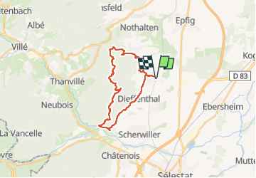
13 km | 18,5 km-effort
4h 38min
![](https://static1.geolcdn.com/siteimages/upload/files/16400158638029165_repeat_loop_refresh_sync_direction_icon.png)
Sí
![Excursión Senderismo Scherwiller - chateau de ortenbourg - Photo](https://media.geolcdn.com/t/375/260/ext.jpg?maxdim=2&url=https%3A%2F%2Fstatic1.geolcdn.com%2Fsiteimages%2Fupload%2Ffiles%2F1553511878bg_sport_marche.png)
![Senderismo Senderismo](https://static1.geolcdn.com/sitytour/trail-icons/101.png)
chateau de ortenbourg
Senderismo
Muy fácil
(1)
Scherwiller,
Gran Este,
Bajo-Rin,
France
![](/images/other/stat-length.png)
4,6 km | 7,9 km-effort
1h 29min
![](https://static1.geolcdn.com/siteimages/upload/files/16400158638029165_repeat_loop_refresh_sync_direction_icon.png)
Sí
![Excursión Senderismo Châtenois - Le Haut Koenigsbourg de Val de Ville - Photo](https://media.geolcdn.com/t/375/260/ext.jpg?maxdim=2&url=https%3A%2F%2Fservices.sitytrail.com%2FGeolivesWS%2FDownloadMedia.ashx%3FTrailID%3D101918%26Media%3D2205_1.jpg)
![Senderismo Senderismo](https://static1.geolcdn.com/sitytour/trail-icons/101.png)
Le Haut Koenigsbourg de Val de Ville
Senderismo
Difícil
(1)
Châtenois,
Gran Este,
Bajo-Rin,
France
![](/images/other/stat-length.png)
16,8 km | 25 km-effort
5h 0min
![](https://static1.geolcdn.com/siteimages/upload/files/16400158638029165_repeat_loop_refresh_sync_direction_icon.png)
Sí
![Excursión Senderismo Dambach-la-Ville - suuntoapp-Hiking-2023-12-26T08-42-47Z - Photo](https://media.geolcdn.com/t/375/260/72166c10-841b-4acc-9a04-0ef640ea51f0.jpg&format=jpg&maxdim=2)
![Senderismo Senderismo](https://static1.geolcdn.com/sitytour/trail-icons/101.png)
suuntoapp-Hiking-2023-12-26T08-42-47Z
Senderismo
Muy difícil
Dambach-la-Ville,
Gran Este,
Bajo-Rin,
France
![](/images/other/stat-length.png)
14,3 km | 21 km-effort
4h 43min
![](https://static1.geolcdn.com/siteimages/upload/files/16400158638029165_repeat_loop_refresh_sync_direction_icon.png)
Sí
![Excursión Paseo ecuestre Epfig - 2022-11-11 Journee Epfig Nothalten Dambach - Photo](https://media.geolcdn.com/t/375/260/f1fca00a-20b5-496a-b785-0710c2a0592f.jpg&format=jpg&maxdim=2)
![Paseo ecuestre Paseo ecuestre](https://static1.geolcdn.com/sitytour/trail-icons/301.png)
2022-11-11 Journee Epfig Nothalten Dambach
Paseo ecuestre
Medio
Epfig,
Gran Este,
Bajo-Rin,
France
![](/images/other/stat-length.png)
22 km | 27 km-effort
3h 48min
![](https://static1.geolcdn.com/siteimages/upload/files/16400158638029165_repeat_loop_refresh_sync_direction_icon.png)
Sí
![Excursión Senderismo Nothalten - nothalten - Photo](https://media.geolcdn.com/t/375/260/ext.jpg?maxdim=2&url=https%3A%2F%2Fstatic1.geolcdn.com%2Fsiteimages%2Fupload%2Ffiles%2F1553511878bg_sport_marche.png)
![Senderismo Senderismo](https://static1.geolcdn.com/sitytour/trail-icons/101.png)
nothalten
Senderismo
Muy fácil
(1)
Nothalten,
Gran Este,
Bajo-Rin,
France
![](/images/other/stat-length.png)
9,6 km | 13 km-effort
2h 13min
![](https://static1.geolcdn.com/siteimages/upload/files/16400158638029165_repeat_loop_refresh_sync_direction_icon.png)
No
![Excursión Senderismo Epfig - ittswiller un jour de pluie - Photo](https://media.geolcdn.com/t/375/260/9125ccbd-a4de-48b2-8773-0936c46bc8ee.jpg&format=jpg&maxdim=2)
![Senderismo Senderismo](https://static1.geolcdn.com/sitytour/trail-icons/101.png)
ittswiller un jour de pluie
Senderismo
Medio
Epfig,
Gran Este,
Bajo-Rin,
France
![](/images/other/stat-length.png)
6,9 km | 9,1 km-effort
1h 52min
![](https://static1.geolcdn.com/siteimages/upload/files/16400158638029165_repeat_loop_refresh_sync_direction_icon.png)
Sí
![Excursión Ruta Dambach-la-Ville - 2023-05-01 Course Trail Tous au Bernstein - Photo](https://media.geolcdn.com/t/375/260/a3614ece-6347-45c6-985f-834886411dae.jpg&format=jpg&maxdim=2)
![Ruta Ruta](https://static1.geolcdn.com/sitytour/trail-icons/104.png)
2023-05-01 Course Trail Tous au Bernstein
Ruta
Difícil
(1)
Dambach-la-Ville,
Gran Este,
Bajo-Rin,
France
![](/images/other/stat-length.png)
24 km | 39 km-effort
3h 11min
![](https://static1.geolcdn.com/siteimages/upload/files/16400158638029165_repeat_loop_refresh_sync_direction_icon.png)
Sí
![Excursión Senderismo Scherwiller - Scherwiller - Chateaux Ramstein-Ortenbourg-Berstein 2022-10 - Photo](https://media.geolcdn.com/t/375/260/2163c1a8-b02b-4f2c-aaa3-de2f4e89bdfa.jpg&format=jpg&maxdim=2)
![Senderismo Senderismo](https://static1.geolcdn.com/sitytour/trail-icons/101.png)
Scherwiller - Chateaux Ramstein-Ortenbourg-Berstein 2022-10
Senderismo
Fácil
Scherwiller,
Gran Este,
Bajo-Rin,
France
![](/images/other/stat-length.png)
14,5 km | 22 km-effort
3h 13min
![](https://static1.geolcdn.com/siteimages/upload/files/16400158638029165_repeat_loop_refresh_sync_direction_icon.png)
Sí