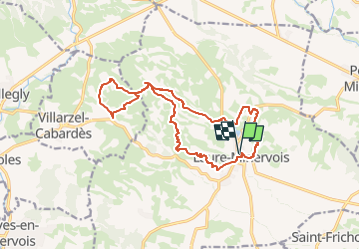
![](/images/other/stat-length.png)
![Excursión Senderismo Laure-Minervois - randogps11-140 - Photo](https://media.geolcdn.com/t/1900/400/ext.pjpeg?maxdim=2&url=https%3A%2F%2Fstatic1.geolcdn.com%2Fsiteimages%2Fupload%2Ffiles%2F1553511878bg_sport_marche.png)
randogps11-140
tercla
Usuario
![Longitud](/images/other/stat-length.png)
![Altitud máxima](https://static1.geolcdn.com/siteimages/upload/files/1508320355ic_sort_altitude_max_24dp.png)
![Desnivel positivo](https://static1.geolcdn.com/siteimages/upload/files/1508320355ic_sort_den_pos_24dp.png)
![Km-Effort](/images/other/stat-length.png)
![Altitud mínima](https://static1.geolcdn.com/siteimages/upload/files/1508320355ic_sort_altitude_min_24dp.png)
![Desnivel negativo](https://static1.geolcdn.com/siteimages/upload/files/1508320355ic_sort_den_neg_24dp.png)
![Boucle](https://static1.geolcdn.com/siteimages/upload/files/16400158638029165_repeat_loop_refresh_sync_direction_icon.png)
![Senderismo](https://static1.geolcdn.com/sitytour/trail-icons/101.png)
5h00
Dificultad : Muy difícil
![Escanee este código QR para abrir la excursión en la aplicación SityTrail](https://capi.geolives.com/qq0zvz2zws4bq2lad0pu/sitytour/trails/4197354/qr.png?size=200)
Aplicación GPS de excursión GRATIS
A propósito
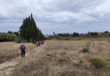
Ruta Senderismo de 17,7 km a descubrir en Occitania, Aude, Laure-Minervois. Esta ruta ha sido propuesta por tercla.
Descripción
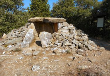
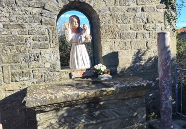
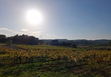
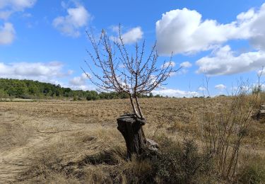
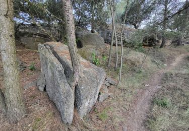
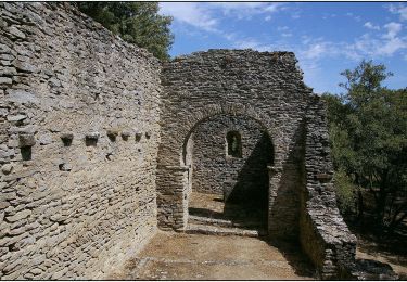
Il fait souvent beau dans ces lieux, et le paysage n'est pas vide... Les capitelles sont là . Visite de Notre Dame de la Lauze et de la nécropole du « Mourel dels Morts », Cette nécropole wisigothique, dont les tombes datent de la fin du Vè au VIIIè siècle, est une des mieux conservées, à ce jour, de la région.
Localización
Comentarios
Excursiones cerca
![Excursión Senderismo Villeneuve-Minervois - Un air d'automne - Villeneuve Minervois - Photo](https://media.geolcdn.com/t/375/260/ext.jpg?maxdim=2&url=https%3A%2F%2Fservices.sitytrail.com%2FGeolivesWS%2FDownloadMedia.ashx%3FTrailID%3D107449%26Media%3D12373_6.jpg)
![Senderismo Senderismo](https://static1.geolcdn.com/sitytour/trail-icons/101.png)
Senderismo
![](/images/other/stat-length.png)
![](https://static1.geolcdn.com/siteimages/upload/files/16400158638029165_repeat_loop_refresh_sync_direction_icon.png)
![Excursión Senderismo Laure-Minervois - Laure Minervois les Capitelles - Photo](https://media.geolcdn.com/t/375/260/4f83098a-901d-478e-8eaa-fad0ae9e544d.jpg&format=jpg&maxdim=2)
![Senderismo Senderismo](https://static1.geolcdn.com/sitytour/trail-icons/101.png)
Senderismo
![](/images/other/stat-length.png)
![](https://static1.geolcdn.com/siteimages/upload/files/16400158638029165_repeat_loop_refresh_sync_direction_icon.png)
![Excursión Senderismo Laure-Minervois - Laure Minervois - Photo](https://media.geolcdn.com/t/375/260/b4f29cc2-5362-425d-a905-9fc323937044.jpg&format=jpg&maxdim=2)
![Senderismo Senderismo](https://static1.geolcdn.com/sitytour/trail-icons/101.png)
Senderismo
![](/images/other/stat-length.png)
![](https://static1.geolcdn.com/siteimages/upload/files/16400158638029165_repeat_loop_refresh_sync_direction_icon.png)
![Excursión A pie Villarzel-Cabardès - Sentier des Wisigoths Villarzel Cabardes - Photo](https://media.geolcdn.com/t/375/260/9be6d263-55a8-4490-a85a-8c17a619cef3.jpg&format=jpg&maxdim=2)
![A pie A pie](https://static1.geolcdn.com/sitytour/trail-icons/100.png)
A pie
![](/images/other/stat-length.png)
![](https://static1.geolcdn.com/siteimages/upload/files/16400158638029165_repeat_loop_refresh_sync_direction_icon.png)
![Excursión Senderismo Saint-Frichoux - CC_Piemont_AE_05_St-Frichoux_Carcassonne_20240615 - Photo](https://media.geolcdn.com/t/375/260/02244347-4176-4094-988f-33738458d604.jpg&format=jpg&maxdim=2)
![Senderismo Senderismo](https://static1.geolcdn.com/sitytour/trail-icons/101.png)
Senderismo
![](/images/other/stat-length.png)
![](https://static1.geolcdn.com/siteimages/upload/files/16400158638029165_repeat_loop_refresh_sync_direction_icon.png)
![Excursión Senderismo Laure-Minervois - Oui mon Capitelle ! 4 niveaux possibles - Photo](https://media.geolcdn.com/t/375/260/e935254c-5573-483d-972d-2b8b10edb813.jpg&format=jpg&maxdim=2)
![Senderismo Senderismo](https://static1.geolcdn.com/sitytour/trail-icons/101.png)
Senderismo
![](/images/other/stat-length.png)
![](https://static1.geolcdn.com/siteimages/upload/files/16400158638029165_repeat_loop_refresh_sync_direction_icon.png)
![Excursión Senderismo Laure-Minervois - laure Minervois capitelles - Photo](https://media.geolcdn.com/t/375/260/233c6f34-2e15-46d6-9460-52ebd66b8dfa.jpg&format=jpg&maxdim=2)
![Senderismo Senderismo](https://static1.geolcdn.com/sitytour/trail-icons/101.png)
Senderismo
![](/images/other/stat-length.png)
![](https://static1.geolcdn.com/siteimages/upload/files/16400158638029165_repeat_loop_refresh_sync_direction_icon.png)
![Excursión Senderismo Villeneuve-Minervois - boucle à Villeneuve Minervois - Photo](https://media.geolcdn.com/t/375/260/ae5417d8-8fd6-4524-ac99-505491b32418.jpg&format=jpg&maxdim=2)
![Senderismo Senderismo](https://static1.geolcdn.com/sitytour/trail-icons/101.png)
Senderismo
![](/images/other/stat-length.png)
![](https://static1.geolcdn.com/siteimages/upload/files/16400158638029165_repeat_loop_refresh_sync_direction_icon.png)
![Excursión A pie Villarzel-Cabardès - Sentiers des Wisigoths - Photo](https://media.geolcdn.com/t/375/260/020d7906-1b44-4f82-9bf7-6ef802f93b09.jpeg&format=jpg&maxdim=2)
![A pie A pie](https://static1.geolcdn.com/sitytour/trail-icons/100.png)
A pie
![](/images/other/stat-length.png)
![](https://static1.geolcdn.com/siteimages/upload/files/16400158638029165_repeat_loop_refresh_sync_direction_icon.png)