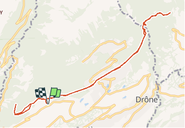
![](/images/other/stat-length.png)
![Excursión Senderismo Savièse - Bisse de Torrent Neuf et Bitailla 04.2015 - Photo](https://media.geolcdn.com/t/1900/400/ext.pjpeg?maxdim=2&url=https%3A%2F%2Fservices.sitytrail.com%2FGeolivesWS%2FDownloadMedia.ashx%3FTrailID%3D419528%26Media%3D741cb471-7f57-4c4f-b74f-2378f85a6546.jpg)
Bisse de Torrent Neuf et Bitailla 04.2015
duamerg
Usuario
![Longitud](/images/other/stat-length.png)
![Altitud máxima](https://static1.geolcdn.com/siteimages/upload/files/1508320355ic_sort_altitude_max_24dp.png)
![Desnivel positivo](https://static1.geolcdn.com/siteimages/upload/files/1508320355ic_sort_den_pos_24dp.png)
![Km-Effort](/images/other/stat-length.png)
![Altitud mínima](https://static1.geolcdn.com/siteimages/upload/files/1508320355ic_sort_altitude_min_24dp.png)
![Desnivel negativo](https://static1.geolcdn.com/siteimages/upload/files/1508320355ic_sort_den_neg_24dp.png)
![Boucle](https://static1.geolcdn.com/siteimages/upload/files/16400158638029165_repeat_loop_refresh_sync_direction_icon.png)
![Senderismo](https://static1.geolcdn.com/sitytour/trail-icons/101.png)
3h40
Dificultad : Fácil
![Escanee este código QR para abrir la excursión en la aplicación SityTrail](https://capi.geolives.com/qq0zvz2zws4bq2lad0pu/sitytour/trails/419528/qr.png?size=200)
Aplicación GPS de excursión GRATIS
A propósito
Ruta Senderismo de 11,6 km a descubrir en Vallés, Sion, Savièse. Esta ruta ha sido propuesta por duamerg.
Descripción
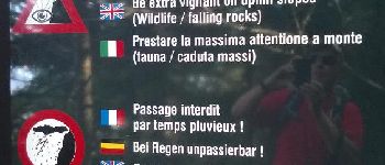
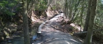
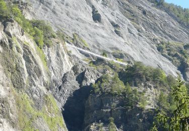
Différents parking sont à disposition dans les hauts de Chandolin (pas très facile à trouver), De là le chemin est bien indiqué. Partir à gauche pour trouver la chapelle Ste Marguerite et le nouveau tronçon ouvert récemment (encore fermé en avril). Agréable ballade en forêt jusqu'à Prafirmin que l'on traverse pour rejoindre le deuxième bisse. A la fin de ce bisse courte et forte montée pour rejoindre le pont qui traverse le Drahin et vous mène par un joli chemin jusqu'à Planeige pour un agréable pic-nic et éventuellement continuer jusqu'à Arbaz. Retour par le même chemin. Agréable ballade avec vue sur les alpes valaisannes.
Localización
Comentarios
Excursiones cerca
![Excursión A pie Savièse - Bisse de Savièse (Torrent-Neuf) - Photo](https://media.geolcdn.com/t/375/260/2abdaf10-00a9-4b07-a19f-cc4e4efb285c.jpeg&format=jpg&maxdim=2)
![A pie A pie](https://static1.geolcdn.com/sitytour/trail-icons/100.png)
A pie
![](/images/other/stat-length.png)
![](https://static1.geolcdn.com/siteimages/upload/files/16400158638029165_repeat_loop_refresh_sync_direction_icon.png)
![Excursión Senderismo Savièse - Mayen de la Zour-Prabé - Photo](https://media.geolcdn.com/t/375/260/ext.jpg?maxdim=2&url=https%3A%2F%2Fstatic1.geolcdn.com%2Fsiteimages%2Fupload%2Ffiles%2F1553511878bg_sport_marche.png)
![Senderismo Senderismo](https://static1.geolcdn.com/sitytour/trail-icons/101.png)
Senderismo
![](/images/other/stat-length.png)
![](https://static1.geolcdn.com/siteimages/upload/files/16400158638029165_repeat_loop_refresh_sync_direction_icon.png)
![Excursión Senderismo Ayent - Au pied du Wildhorn - Photo](https://media.geolcdn.com/t/375/260/ext.jpg?maxdim=2&url=https%3A%2F%2Fstatic1.geolcdn.com%2Fsiteimages%2Fupload%2Ffiles%2F1553511878bg_sport_marche.png)
![Senderismo Senderismo](https://static1.geolcdn.com/sitytour/trail-icons/101.png)
Senderismo
![](/images/other/stat-length.png)
![](https://static1.geolcdn.com/siteimages/upload/files/16400158638029165_repeat_loop_refresh_sync_direction_icon.png)
![Excursión A pie Conthey - Bisse de la Tsandra - Photo](https://media.geolcdn.com/t/375/260/1657d19d-aa60-4f9b-8a51-722366c997ed.jpeg&format=jpg&maxdim=2)
![A pie A pie](https://static1.geolcdn.com/sitytour/trail-icons/100.png)
A pie
![](/images/other/stat-length.png)
![](https://static1.geolcdn.com/siteimages/upload/files/16400158638029165_repeat_loop_refresh_sync_direction_icon.png)
![Excursión Marcha nórdica Arbaz - Grimisuat - Photo](https://media.geolcdn.com/t/375/260/7db261da-47d1-45af-86a8-5f533a77d10f.jpg&format=jpg&maxdim=2)
![Marcha nórdica Marcha nórdica](https://static1.geolcdn.com/sitytour/trail-icons/102.png)
Marcha nórdica
![](/images/other/stat-length.png)
![](https://static1.geolcdn.com/siteimages/upload/files/16400158638029165_repeat_loop_refresh_sync_direction_icon.png)
![Excursión Marcha nórdica Ayent - 07.08.20 Tour des Alpages - Photo](https://media.geolcdn.com/t/375/260/847ec8c8-ca52-45ee-88b9-2d42ecd58e52.jpg&format=jpg&maxdim=2)
![Marcha nórdica Marcha nórdica](https://static1.geolcdn.com/sitytour/trail-icons/102.png)
Marcha nórdica
![](/images/other/stat-length.png)
![](https://static1.geolcdn.com/siteimages/upload/files/16400158638029165_repeat_loop_refresh_sync_direction_icon.png)
![Excursión Marcha nórdica Arbaz - 27.07.20 Pas de Maimbré - Photo](https://media.geolcdn.com/t/375/260/b8e2c4c6-f220-4a39-9235-6deb05a62b05.jpg&format=jpg&maxdim=2)
![Marcha nórdica Marcha nórdica](https://static1.geolcdn.com/sitytour/trail-icons/102.png)
Marcha nórdica
![](/images/other/stat-length.png)
![](https://static1.geolcdn.com/siteimages/upload/files/16400158638029165_repeat_loop_refresh_sync_direction_icon.png)
![Excursión Marcha nórdica Arbaz - 23.07.20 Anzère - Photo](https://media.geolcdn.com/t/375/260/6936dbcc-15e7-4a23-9260-f5f09bf86c64.jpg&format=jpg&maxdim=2)
![Marcha nórdica Marcha nórdica](https://static1.geolcdn.com/sitytour/trail-icons/102.png)
Marcha nórdica
![](/images/other/stat-length.png)
![](https://static1.geolcdn.com/siteimages/upload/files/16400158638029165_repeat_loop_refresh_sync_direction_icon.png)