![](/images/other/stat-length.png)
![Excursión Senderismo Lelin-Lapujolle - Compostelle 2 étapes Lelin Miramont Pomps - Photo](https://media.geolcdn.com/t/1900/400/ext.pjpeg?maxdim=2&url=https%3A%2F%2Fstatic1.geolcdn.com%2Fsiteimages%2Fupload%2Ffiles%2F1553511878bg_sport_marche.png)
Compostelle 2 étapes Lelin Miramont Pomps
Nono55
Usuario
![Longitud](/images/other/stat-length.png)
Longitud
78 km
![Altitud máxima](https://static1.geolcdn.com/siteimages/upload/files/1508320355ic_sort_altitude_max_24dp.png)
Altitud máxima
247 m
![Desnivel positivo](https://static1.geolcdn.com/siteimages/upload/files/1508320355ic_sort_den_pos_24dp.png)
Desnivel positivo
1050 m
![Km-Effort](/images/other/stat-length.png)
Km-Effort
92 km
![Altitud mínima](https://static1.geolcdn.com/siteimages/upload/files/1508320355ic_sort_altitude_min_24dp.png)
Altitud mínima
78 m
![Desnivel negativo](https://static1.geolcdn.com/siteimages/upload/files/1508320355ic_sort_den_neg_24dp.png)
Desnivel negativo
1056 m
![Boucle](https://static1.geolcdn.com/siteimages/upload/files/16400158638029165_repeat_loop_refresh_sync_direction_icon.png)
Boucle
No
Fecha de creación :
2024-09-17 06:05:48.0
Última modificación :
2024-09-18 16:35:13.33
![Senderismo](https://static1.geolcdn.com/sitytour/trail-icons/101.png)
15h17
Dificultad : Medio
![Escanee este código QR para abrir la excursión en la aplicación SityTrail](https://capi.geolives.com/qq0zvz2zws4bq2lad0pu/sitytour/trails/4194411/qr.png?size=200)
Aplicación GPS de excursión GRATIS
A propósito
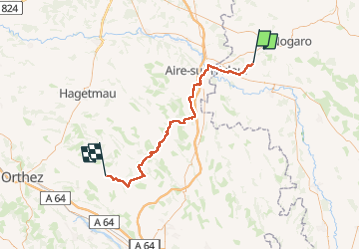
Ruta Senderismo de 78 km a descubrir en Occitania, Gers, Lelin-Lapujolle. Esta ruta ha sido propuesta por Nono55.
Descripción
Début d étape super chemin de sous bois très vallonné puis route route et route heureusement super paysage et beau village
Localización
País:
France
Región :
Occitania
Departamento/provincia :
Gers
Municipio :
Lelin-Lapujolle
Localidad:
Unknown
Salida:(Dec)
Salida:(UTM)
730629 ; 4844141 (30T) N.
Comentarios
Excursiones cerca
![Senderismo Senderismo](https://static1.geolcdn.com/sitytour/trail-icons/101.png)
CC_Velay_FA_24_Lanne-Soubiran_Aire-Adour_20081109
Senderismo
Fácil
Lanne-Soubiran,
Occitania,
Gers,
France
![](/images/other/stat-length.png)
25 km | 29 km-effort
6h 15min
![](https://static1.geolcdn.com/siteimages/upload/files/16400158638029165_repeat_loop_refresh_sync_direction_icon.png)
No
![Excursión Senderismo Lanne-Soubiran - Compostelle 22 1er Etape - Photo](https://media.geolcdn.com/t/375/260/ext.jpg?maxdim=2&url=https%3A%2F%2Fstatic1.geolcdn.com%2Fsiteimages%2Fupload%2Ffiles%2F1553511878bg_sport_marche.png)
![Senderismo Senderismo](https://static1.geolcdn.com/sitytour/trail-icons/101.png)
Compostelle 22 1er Etape
Senderismo
Fácil
Lanne-Soubiran,
Occitania,
Gers,
France
![](/images/other/stat-length.png)
18,8 km | 21 km-effort
4h 51min
![](https://static1.geolcdn.com/siteimages/upload/files/16400158638029165_repeat_loop_refresh_sync_direction_icon.png)
No
![Excursión Senderismo Lanne-Soubiran - Aire sur l'Adour - Photo](https://media.geolcdn.com/t/375/260/ext.jpg?maxdim=2&url=https%3A%2F%2Fstatic1.geolcdn.com%2Fsiteimages%2Fupload%2Ffiles%2F1553511878bg_sport_marche.png)
![Senderismo Senderismo](https://static1.geolcdn.com/sitytour/trail-icons/101.png)
Aire sur l'Adour
Senderismo
Fácil
Lanne-Soubiran,
Occitania,
Gers,
France
![](/images/other/stat-length.png)
22 km | 25 km-effort
9h 40min
![](https://static1.geolcdn.com/siteimages/upload/files/16400158638029165_repeat_loop_refresh_sync_direction_icon.png)
No
![Excursión Senderismo Arblade-le-Bas - OR-6947886--Arblade-le-Bas:Airblade le bas-mirmont-sensacq-8 - Photo](https://media.geolcdn.com/t/375/260/ext.jpg?maxdim=2&url=https%3A%2F%2Fstatic1.geolcdn.com%2Fsiteimages%2Fupload%2Ffiles%2F1553511878bg_sport_marche.png)
![Senderismo Senderismo](https://static1.geolcdn.com/sitytour/trail-icons/101.png)
OR-6947886--Arblade-le-Bas:Airblade le bas-mirmont-sensacq-8
Senderismo
Muy fácil
Arblade-le-Bas,
Occitania,
Gers,
France
![](/images/other/stat-length.png)
26 km | 30 km-effort
6h 34min
![](https://static1.geolcdn.com/siteimages/upload/files/16400158638029165_repeat_loop_refresh_sync_direction_icon.png)
No
![Excursión Senderismo Lelin-Lapujolle - St Jacques Étape 29 réalisée - Photo](https://media.geolcdn.com/t/375/260/ext.jpg?maxdim=2&url=https%3A%2F%2Fstatic1.geolcdn.com%2Fsiteimages%2Fupload%2Ffiles%2F1553511878bg_sport_marche.png)
![Senderismo Senderismo](https://static1.geolcdn.com/sitytour/trail-icons/101.png)
St Jacques Étape 29 réalisée
Senderismo
Muy fácil
Lelin-Lapujolle,
Occitania,
Gers,
France
![](/images/other/stat-length.png)
24 km | 27 km-effort
6h 9min
![](https://static1.geolcdn.com/siteimages/upload/files/16400158638029165_repeat_loop_refresh_sync_direction_icon.png)
No
![Excursión Marcha nórdica Lanne-Soubiran - De Miramont-Sensac à Aire-sur-Adour - Photo](https://media.geolcdn.com/t/375/260/ext.jpg?maxdim=2&url=https%3A%2F%2Fstatic1.geolcdn.com%2Fsiteimages%2Fupload%2Ffiles%2F1545311037marcheuse_200dpi.jpg)
![Marcha nórdica Marcha nórdica](https://static1.geolcdn.com/sitytour/trail-icons/102.png)
De Miramont-Sensac à Aire-sur-Adour
Marcha nórdica
Medio
Lanne-Soubiran,
Occitania,
Gers,
France
![](/images/other/stat-length.png)
23 km | 26 km-effort
7h 24min
![](https://static1.geolcdn.com/siteimages/upload/files/16400158638029165_repeat_loop_refresh_sync_direction_icon.png)
No
![Excursión Senderismo Lanne-Soubiran - compostelle lanne Soubiran aire sur Adour - Photo](https://media.geolcdn.com/t/375/260/ext.jpg?maxdim=2&url=https%3A%2F%2Fstatic1.geolcdn.com%2Fsiteimages%2Fupload%2Ffiles%2F1553511878bg_sport_marche.png)
![Senderismo Senderismo](https://static1.geolcdn.com/sitytour/trail-icons/101.png)
compostelle lanne Soubiran aire sur Adour
Senderismo
Muy difícil
Lanne-Soubiran,
Occitania,
Gers,
France
![](/images/other/stat-length.png)
20 km | 23 km-effort
5h 0min
![](https://static1.geolcdn.com/siteimages/upload/files/16400158638029165_repeat_loop_refresh_sync_direction_icon.png)
No
![Excursión Senderismo Lanne-Soubiran - presbytère-Aire sur l'Adour - Photo](https://media.geolcdn.com/t/375/260/ext.jpg?maxdim=2&url=https%3A%2F%2Fstatic1.geolcdn.com%2Fsiteimages%2Fupload%2Ffiles%2F1553511878bg_sport_marche.png)
![Senderismo Senderismo](https://static1.geolcdn.com/sitytour/trail-icons/101.png)
presbytère-Aire sur l'Adour
Senderismo
Muy difícil
Lanne-Soubiran,
Occitania,
Gers,
France
![](/images/other/stat-length.png)
21 km | 23 km-effort
4h 46min
![](https://static1.geolcdn.com/siteimages/upload/files/16400158638029165_repeat_loop_refresh_sync_direction_icon.png)
No
![Excursión Senderismo Lanne-Soubiran - 70_19_02 Lanne-Soubiran Aire Sur - Photo](https://media.geolcdn.com/t/375/260/ext.jpg?maxdim=2&url=https%3A%2F%2Fstatic1.geolcdn.com%2Fsiteimages%2Fupload%2Ffiles%2F1553511878bg_sport_marche.png)
![Senderismo Senderismo](https://static1.geolcdn.com/sitytour/trail-icons/101.png)
70_19_02 Lanne-Soubiran Aire Sur
Senderismo
Fácil
Lanne-Soubiran,
Occitania,
Gers,
France
![](/images/other/stat-length.png)
19,8 km | 23 km-effort
5h 7min
![](https://static1.geolcdn.com/siteimages/upload/files/16400158638029165_repeat_loop_refresh_sync_direction_icon.png)
No