![](/images/other/stat-length.png)
![Excursión Senderismo Nogent-le-Bernard - la belle allée - Photo](https://media.geolcdn.com/t/1900/400/ext.pjpeg?maxdim=2&url=https%3A%2F%2Fstatic1.geolcdn.com%2Fsiteimages%2Fupload%2Ffiles%2F1553511878bg_sport_marche.png)
la belle allée
darkpapa
Usuario
![Longitud](/images/other/stat-length.png)
Longitud
10 km
![Altitud máxima](https://static1.geolcdn.com/siteimages/upload/files/1508320355ic_sort_altitude_max_24dp.png)
Altitud máxima
169 m
![Desnivel positivo](https://static1.geolcdn.com/siteimages/upload/files/1508320355ic_sort_den_pos_24dp.png)
Desnivel positivo
152 m
![Km-Effort](/images/other/stat-length.png)
Km-Effort
12 km
![Altitud mínima](https://static1.geolcdn.com/siteimages/upload/files/1508320355ic_sort_altitude_min_24dp.png)
Altitud mínima
107 m
![Desnivel negativo](https://static1.geolcdn.com/siteimages/upload/files/1508320355ic_sort_den_neg_24dp.png)
Desnivel negativo
152 m
![Boucle](https://static1.geolcdn.com/siteimages/upload/files/16400158638029165_repeat_loop_refresh_sync_direction_icon.png)
Boucle
Sí
Fecha de creación :
2024-09-18 06:28:54.92
Última modificación :
2025-01-23 10:51:54.088
![Senderismo](https://static1.geolcdn.com/sitytour/trail-icons/101.png)
2h43
Dificultad : Fácil
![Escanee este código QR para abrir la excursión en la aplicación SityTrail](https://capi.geolives.com/qq0zvz2zws4bq2lad0pu/sitytour/trails/4193623/qr.png?size=200)
Aplicación GPS de excursión GRATIS
A propósito
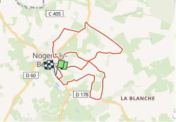
Ruta Senderismo de 10 km a descubrir en Países del Loira, Sarthe, Nogent-le-Bernard. Esta ruta ha sido propuesta por darkpapa.
Descripción
départ / retour parking cimetière ou terrain de sport
possibilite de scinder le parcours en 2 6 4 km
Localización
País:
France
Región :
Países del Loira
Departamento/provincia :
Sarthe
Municipio :
Nogent-le-Bernard
Localidad:
Unknown
Salida:(Dec)
Salida:(UTM)
313795 ; 5345161 (31U) N.
Comentarios
Excursiones cerca
![Excursión Senderismo Bellou-le-Trichard - Bellou le Trichard - Photo](https://media.geolcdn.com/t/375/260/d730ddcd-c6fe-4fa0-bf85-c5cdf818a38f.jpg&format=jpg&maxdim=2)
![Senderismo Senderismo](https://static1.geolcdn.com/sitytour/trail-icons/101.png)
Bellou le Trichard
Senderismo
Fácil
Bellou-le-Trichard,
Normandía,
Orne,
France
![](/images/other/stat-length.png)
10 km | 12,5 km-effort
2h 49min
![](https://static1.geolcdn.com/siteimages/upload/files/16400158638029165_repeat_loop_refresh_sync_direction_icon.png)
Sí
![Excursión Senderismo Nogent-le-Bernard - Nogent le Bernard - Chemin faisant... - Photo](https://media.geolcdn.com/t/375/260/ext.jpg?maxdim=2&url=https%3A%2F%2Fservices.sitytrail.com%2FGeolivesWS%2FDownloadMedia.ashx%3FTrailID%3D110412%26Media%3D5881_1.jpg)
![Senderismo Senderismo](https://static1.geolcdn.com/sitytour/trail-icons/101.png)
Nogent le Bernard - Chemin faisant...
Senderismo
Medio
Nogent-le-Bernard,
Países del Loira,
Sarthe,
France
![](/images/other/stat-length.png)
10,5 km | 12,7 km-effort
2h 0min
![](https://static1.geolcdn.com/siteimages/upload/files/16400158638029165_repeat_loop_refresh_sync_direction_icon.png)
Sí
![Excursión Senderismo Saint-Georges-du-Rosay - St Georges du Rosay - Chemins buissonniers - Photo](https://media.geolcdn.com/t/375/260/ext.jpg?maxdim=2&url=https%3A%2F%2Fservices.sitytrail.com%2FGeolivesWS%2FDownloadMedia.ashx%3FTrailID%3D110406%26Media%3D5874_1.jpg)
![Senderismo Senderismo](https://static1.geolcdn.com/sitytour/trail-icons/101.png)
St Georges du Rosay - Chemins buissonniers
Senderismo
Medio
Saint-Georges-du-Rosay,
Países del Loira,
Sarthe,
France
![](/images/other/stat-length.png)
14,7 km | 16,2 km-effort
3h 0min
![](https://static1.geolcdn.com/siteimages/upload/files/16400158638029165_repeat_loop_refresh_sync_direction_icon.png)
Sí
![Excursión Senderismo Bellou-le-Trichard - de Bellou au manoir de bray - Photo](https://media.geolcdn.com/t/375/260/ext.jpg?maxdim=2&url=https%3A%2F%2Fstatic1.geolcdn.com%2Fsiteimages%2Fupload%2Ffiles%2F1553511878bg_sport_marche.png)
![Senderismo Senderismo](https://static1.geolcdn.com/sitytour/trail-icons/101.png)
de Bellou au manoir de bray
Senderismo
Muy difícil
Bellou-le-Trichard,
Normandía,
Orne,
France
![](/images/other/stat-length.png)
21 km | 25 km-effort
5h 46min
![](https://static1.geolcdn.com/siteimages/upload/files/16400158638029165_repeat_loop_refresh_sync_direction_icon.png)
Sí
![Excursión Senderismo Nogent-le-Bernard - le Moulins du Houx - Photo](https://media.geolcdn.com/t/375/260/ext.jpg?maxdim=2&url=https%3A%2F%2Fstatic1.geolcdn.com%2Fsiteimages%2Fupload%2Ffiles%2F1553511878bg_sport_marche.png)
![Senderismo Senderismo](https://static1.geolcdn.com/sitytour/trail-icons/101.png)
le Moulins du Houx
Senderismo
Fácil
Nogent-le-Bernard,
Países del Loira,
Sarthe,
France
![](/images/other/stat-length.png)
9,1 km | 11,3 km-effort
2h 34min
![](https://static1.geolcdn.com/siteimages/upload/files/16400158638029165_repeat_loop_refresh_sync_direction_icon.png)
Sí
![Excursión Senderismo Saint-Georges-du-Rosay - la source du rosay - Photo](https://media.geolcdn.com/t/375/260/ext.jpg?maxdim=2&url=https%3A%2F%2Fstatic1.geolcdn.com%2Fsiteimages%2Fupload%2Ffiles%2F1553511878bg_sport_marche.png)
![Senderismo Senderismo](https://static1.geolcdn.com/sitytour/trail-icons/101.png)
la source du rosay
Senderismo
Fácil
Saint-Georges-du-Rosay,
Países del Loira,
Sarthe,
France
![](/images/other/stat-length.png)
10,4 km | 11,5 km-effort
2h 36min
![](https://static1.geolcdn.com/siteimages/upload/files/16400158638029165_repeat_loop_refresh_sync_direction_icon.png)
Sí
![Excursión Bicicleta Saint-Cosme-en-Vairais - De Saint Cosme en Vairais à Mézières sur Ponthouin - Photo](https://media.geolcdn.com/t/375/260/ext.jpg?maxdim=2&url=https%3A%2F%2Fservices.sitytrail.com%2FGeolivesWS%2FDownloadMedia.ashx%3FTrailID%3D107663%26Media%3D12659_1.jpg)
![Bicicleta Bicicleta](https://static1.geolcdn.com/sitytour/trail-icons/200.png)
De Saint Cosme en Vairais à Mézières sur Ponthouin
Bicicleta
Fácil
Saint-Cosme-en-Vairais,
Países del Loira,
Sarthe,
France
![](/images/other/stat-length.png)
40 km | 44 km-effort
1h 45min
![](https://static1.geolcdn.com/siteimages/upload/files/16400158638029165_repeat_loop_refresh_sync_direction_icon.png)
Sí
![Excursión Senderismo Nogent-le-Bernard - Nogent le Bernard 24.90-17879731 - Photo](https://media.geolcdn.com/t/375/260/ext.jpg?maxdim=2&url=https%3A%2F%2Fstatic1.geolcdn.com%2Fsiteimages%2Fupload%2Ffiles%2F1553511878bg_sport_marche.png)
![Senderismo Senderismo](https://static1.geolcdn.com/sitytour/trail-icons/101.png)
Nogent le Bernard 24.90-17879731
Senderismo
Medio
Nogent-le-Bernard,
Países del Loira,
Sarthe,
France
![](/images/other/stat-length.png)
25 km | 29 km-effort
Desconocido
![](https://static1.geolcdn.com/siteimages/upload/files/16400158638029165_repeat_loop_refresh_sync_direction_icon.png)
Sí
![Excursión Senderismo Nogent-le-Bernard - 15365520-Nogent le Bernard 17.19 - Photo](https://media.geolcdn.com/t/375/260/ext.jpg?maxdim=2&url=https%3A%2F%2Fstatic1.geolcdn.com%2Fsiteimages%2Fupload%2Ffiles%2F1553511878bg_sport_marche.png)
![Senderismo Senderismo](https://static1.geolcdn.com/sitytour/trail-icons/101.png)
15365520-Nogent le Bernard 17.19
Senderismo
Medio
Nogent-le-Bernard,
Países del Loira,
Sarthe,
France
![](/images/other/stat-length.png)
17,2 km | 19,5 km-effort
Desconocido
![](https://static1.geolcdn.com/siteimages/upload/files/16400158638029165_repeat_loop_refresh_sync_direction_icon.png)
Sí