![](/images/other/stat-length.png)
![Excursión Senderismo Wimereux - Les dunes de la Slack - Photo](https://media.geolcdn.com/t/1900/400/ext.pjpeg?maxdim=2&url=https%3A%2F%2Fstatic1.geolcdn.com%2Fsiteimages%2Fupload%2Ffiles%2F1553511878bg_sport_marche.png)
Les dunes de la Slack
micheldutilleul
Usuario
![Longitud](/images/other/stat-length.png)
Longitud
12,6 km
![Altitud máxima](https://static1.geolcdn.com/siteimages/upload/files/1508320355ic_sort_altitude_max_24dp.png)
Altitud máxima
41 m
![Desnivel positivo](https://static1.geolcdn.com/siteimages/upload/files/1508320355ic_sort_den_pos_24dp.png)
Desnivel positivo
107 m
![Km-Effort](/images/other/stat-length.png)
Km-Effort
14 km
![Altitud mínima](https://static1.geolcdn.com/siteimages/upload/files/1508320355ic_sort_altitude_min_24dp.png)
Altitud mínima
0 m
![Desnivel negativo](https://static1.geolcdn.com/siteimages/upload/files/1508320355ic_sort_den_neg_24dp.png)
Desnivel negativo
102 m
![Boucle](https://static1.geolcdn.com/siteimages/upload/files/16400158638029165_repeat_loop_refresh_sync_direction_icon.png)
Boucle
Sí
Fecha de creación :
2024-09-14 11:57:39.733
Última modificación :
2024-09-14 16:04:32.76
![Senderismo](https://static1.geolcdn.com/sitytour/trail-icons/101.png)
3h05
Dificultad : Medio
![Escanee este código QR para abrir la excursión en la aplicación SityTrail](https://capi.geolives.com/qq0zvz2zws4bq2lad0pu/sitytour/trails/4189759/qr.png?size=200)
Aplicación GPS de excursión GRATIS
A propósito
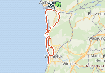
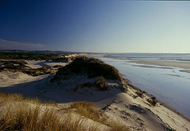
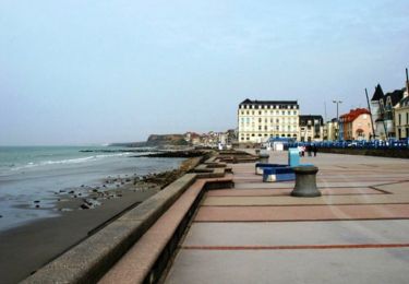
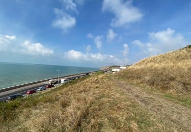
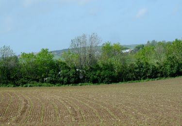
Ruta Senderismo de 12,6 km a descubrir en Alta Francia, Paso de Calais, Wimereux. Esta ruta ha sido propuesta por micheldutilleul.
Descripción
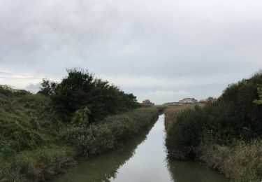
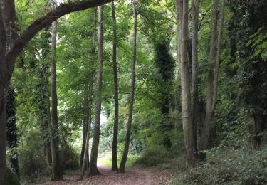
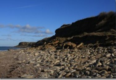
Balade passant le long du littoral, dans la ville de Wimereux, les dunes et les bois.
Tres chouette balade,excepté un passage dans la ville le long du littoral.
Localización
País:
France
Región :
Alta Francia
Departamento/provincia :
Paso de Calais
Municipio :
Wimereux
Localidad:
Unknown
Salida:(Dec)
Salida:(UTM)
402242 ; 5628896 (31U) N.
Comentarios
Excursiones cerca
![Excursión Senderismo Wimereux - Promenade des Dunes de la Slack - Photo](https://media.geolcdn.com/t/375/260/ext.jpg?maxdim=2&url=https%3A%2F%2Fservices.sitytrail.com%2FGeolivesWS%2FDownloadMedia.ashx%3FTrailID%3D647521%26Media%3D59f52238-6e50-4f13-bf2d-3775f9e51a6a.jpg)
![Senderismo Senderismo](https://static1.geolcdn.com/sitytour/trail-icons/101.png)
Promenade des Dunes de la Slack
Senderismo
Muy fácil
(9)
Wimereux,
Alta Francia,
Paso de Calais,
France
![](/images/other/stat-length.png)
6 km | 6,8 km-effort
1h 30min
![](https://static1.geolcdn.com/siteimages/upload/files/16400158638029165_repeat_loop_refresh_sync_direction_icon.png)
Sí
![Excursión Senderismo Wimille - Balade sur le sentier du Denacre - Photo](https://media.geolcdn.com/t/375/260/ext.jpg?maxdim=2&url=https%3A%2F%2Fservices.sitytrail.com%2FGeolivesWS%2FDownloadMedia.ashx%3FTrailID%3D638580%26Media%3Dbb03aebe-b688-479d-8773-5a86670387c9.jpg)
![Senderismo Senderismo](https://static1.geolcdn.com/sitytour/trail-icons/101.png)
Balade sur le sentier du Denacre
Senderismo
Muy fácil
(5)
Wimille,
Alta Francia,
Paso de Calais,
France
![](/images/other/stat-length.png)
9,8 km | 11,4 km-effort
2h 30min
![](https://static1.geolcdn.com/siteimages/upload/files/16400158638029165_repeat_loop_refresh_sync_direction_icon.png)
Sí
![Excursión Senderismo Audinghen - Sentier cotier Audresselles - Audinghen - Photo](https://media.geolcdn.com/t/375/260/ext.jpg?maxdim=2&url=https%3A%2F%2Fservices.sitytrail.com%2FGeolivesWS%2FDownloadMedia.ashx%3FTrailID%3D106662%26Media%3D11283_3.jpg)
![Senderismo Senderismo](https://static1.geolcdn.com/sitytour/trail-icons/101.png)
Sentier cotier Audresselles - Audinghen
Senderismo
Medio
(1)
Audinghen,
Alta Francia,
Paso de Calais,
France
![](/images/other/stat-length.png)
5,8 km | 7 km-effort
1h 30min
![](https://static1.geolcdn.com/siteimages/upload/files/16400158638029165_repeat_loop_refresh_sync_direction_icon.png)
Sí
![Excursión Bici de montaña Wimereux - Le littoral de Wimereux à Etaples - Photo](https://media.geolcdn.com/t/375/260/ext.jpg?maxdim=2&url=https%3A%2F%2Fservices.sitytrail.com%2FGeolivesWS%2FDownloadMedia.ashx%3FTrailID%3D191453%26Media%3D15044_1.jpg)
![Bici de montaña Bici de montaña](https://static1.geolcdn.com/sitytour/trail-icons/202.png)
Le littoral de Wimereux à Etaples
Bici de montaña
Medio
(1)
Wimereux,
Alta Francia,
Paso de Calais,
France
![](/images/other/stat-length.png)
35 km | 41 km-effort
3h 0min
![](https://static1.geolcdn.com/siteimages/upload/files/16400158638029165_repeat_loop_refresh_sync_direction_icon.png)
No
![Excursión Senderismo Wimereux - Wimereux - La Crèche - Photo](https://media.geolcdn.com/t/375/260/ext.jpg?maxdim=2&url=https%3A%2F%2Fservices.sitytrail.com%2FGeolivesWS%2FDownloadMedia.ashx%3FTrailID%3D103740%26Media%3D6466_2.jpg)
![Senderismo Senderismo](https://static1.geolcdn.com/sitytour/trail-icons/101.png)
Wimereux - La Crèche
Senderismo
Medio
(4)
Wimereux,
Alta Francia,
Paso de Calais,
France
![](/images/other/stat-length.png)
9,3 km | 11,4 km-effort
2h 15min
![](https://static1.geolcdn.com/siteimages/upload/files/16400158638029165_repeat_loop_refresh_sync_direction_icon.png)
Sí
![Excursión Senderismo Wimereux - Wimereux Boulogne - Photo](https://media.geolcdn.com/t/375/260/c5b357de-a1ef-4826-80ff-4a1d95018f9a.jpg&format=jpg&maxdim=2)
![Senderismo Senderismo](https://static1.geolcdn.com/sitytour/trail-icons/101.png)
Wimereux Boulogne
Senderismo
Wimereux,
Alta Francia,
Paso de Calais,
France
![](/images/other/stat-length.png)
8,1 km | 10,1 km-effort
2h 35min
![](https://static1.geolcdn.com/siteimages/upload/files/16400158638029165_repeat_loop_refresh_sync_direction_icon.png)
Sí
![Excursión A pie Bazinghen - Sentier Les Voyettes - Photo](https://media.geolcdn.com/t/375/260/b6cdb1eb-ec5b-4936-8deb-094b1180094d.jpeg&format=jpg&maxdim=2)
![A pie A pie](https://static1.geolcdn.com/sitytour/trail-icons/100.png)
Sentier Les Voyettes
A pie
Fácil
Bazinghen,
Alta Francia,
Paso de Calais,
France
![](/images/other/stat-length.png)
9 km | 11,8 km-effort
2h 41min
![](https://static1.geolcdn.com/siteimages/upload/files/16400158638029165_repeat_loop_refresh_sync_direction_icon.png)
Sí
![Excursión Senderismo Audinghen - Audresselles par falaise et campagne - Photo](https://media.geolcdn.com/t/375/260/ext.jpg?maxdim=2&url=https%3A%2F%2Fservices.sitytrail.com%2FGeolivesWS%2FDownloadMedia.ashx%3FTrailID%3D934511%26Media%3Dfix__20180401161107.jpg)
![Senderismo Senderismo](https://static1.geolcdn.com/sitytour/trail-icons/101.png)
Audresselles par falaise et campagne
Senderismo
Medio
Audinghen,
Alta Francia,
Paso de Calais,
France
![](/images/other/stat-length.png)
6,2 km | 7,3 km-effort
1h 53min
![](https://static1.geolcdn.com/siteimages/upload/files/16400158638029165_repeat_loop_refresh_sync_direction_icon.png)
Sí
![Excursión Senderismo Audinghen - Audinghen Sentier des Crans - Photo](https://media.geolcdn.com/t/375/260/ext.jpg?maxdim=2&url=https%3A%2F%2Fstatic1.geolcdn.com%2Fsiteimages%2Fupload%2Ffiles%2F1553511878bg_sport_marche.png)
![Senderismo Senderismo](https://static1.geolcdn.com/sitytour/trail-icons/101.png)
Audinghen Sentier des Crans
Senderismo
Medio
(1)
Audinghen,
Alta Francia,
Paso de Calais,
France
![](/images/other/stat-length.png)
15,1 km | 17,7 km-effort
3h 53min
![](https://static1.geolcdn.com/siteimages/upload/files/16400158638029165_repeat_loop_refresh_sync_direction_icon.png)
Sí