![](/images/other/stat-length.png)
![Excursión Senderismo La Forge - La roche des corbeaux, La Forge - Photo](https://media.geolcdn.com/t/1900/400/130216fa-767d-4902-bf97-0a8dff8eb2b3.jpg&format=pjpeg&maxdim=2)
La roche des corbeaux, La Forge
FouargePatrick
Usuario
![Longitud](/images/other/stat-length.png)
Longitud
7,8 km
![Altitud máxima](https://static1.geolcdn.com/siteimages/upload/files/1508320355ic_sort_altitude_max_24dp.png)
Altitud máxima
748 m
![Desnivel positivo](https://static1.geolcdn.com/siteimages/upload/files/1508320355ic_sort_den_pos_24dp.png)
Desnivel positivo
263 m
![Km-Effort](/images/other/stat-length.png)
Km-Effort
11,2 km
![Altitud mínima](https://static1.geolcdn.com/siteimages/upload/files/1508320355ic_sort_altitude_min_24dp.png)
Altitud mínima
525 m
![Desnivel negativo](https://static1.geolcdn.com/siteimages/upload/files/1508320355ic_sort_den_neg_24dp.png)
Desnivel negativo
254 m
![Boucle](https://static1.geolcdn.com/siteimages/upload/files/16400158638029165_repeat_loop_refresh_sync_direction_icon.png)
Boucle
Sí
Fecha de creación :
2024-09-12 08:45:51.0
Última modificación :
2024-09-13 20:31:06.593
![Senderismo](https://static1.geolcdn.com/sitytour/trail-icons/101.png)
2h33
Dificultad : Medio
![Escanee este código QR para abrir la excursión en la aplicación SityTrail](https://capi.geolives.com/qq0zvz2zws4bq2lad0pu/sitytour/trails/4187086/qr.png?size=200)
Aplicación GPS de excursión GRATIS
A propósito
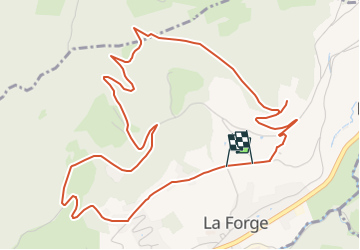
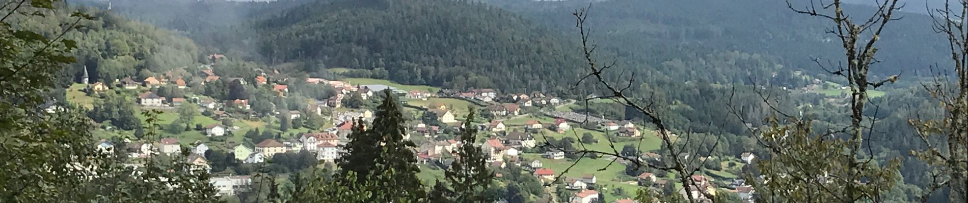
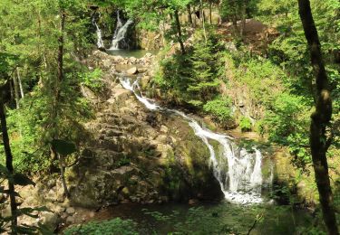
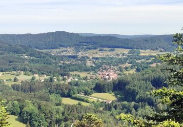
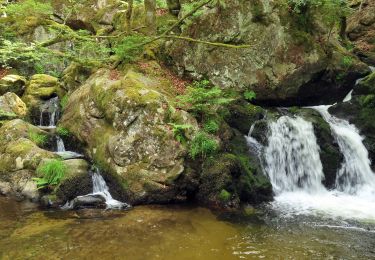
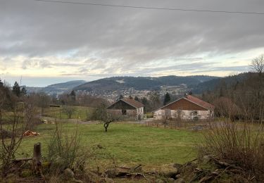
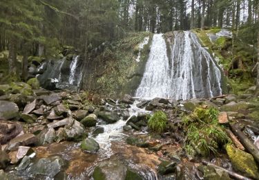
Ruta Senderismo de 7,8 km a descubrir en Gran Este, Vosgos, La Forge. Esta ruta ha sido propuesta por FouargePatrick.
Descripción
Boucle au départ de la Rue des Ramées, suivre le sentier balisé "rond bleu" ver la Roche des Corbeaux.
Tracé impossible avec une poussette d'enfant.
Localización
País:
France
Región :
Gran Este
Departamento/provincia :
Vosgos
Municipio :
La Forge
Localidad:
Unknown
Salida:(Dec)
Salida:(UTM)
330493 ; 5326532 (32U) N.
Comentarios
Excursiones cerca
![Excursión Senderismo Tendon - Cascades de Tendon - Trou de l'Enfer - Roches de la Moulure - Photo](https://media.geolcdn.com/t/375/260/6cb30f79-01f0-4a87-b35f-5f5af3475353.jpg&format=jpg&maxdim=2)
![Senderismo Senderismo](https://static1.geolcdn.com/sitytour/trail-icons/101.png)
Cascades de Tendon - Trou de l'Enfer - Roches de la Moulure
Senderismo
Medio
(4)
Tendon,
Gran Este,
Vosgos,
France
![](/images/other/stat-length.png)
20 km | 28 km-effort
5h 33min
![](https://static1.geolcdn.com/siteimages/upload/files/16400158638029165_repeat_loop_refresh_sync_direction_icon.png)
Sí
![Excursión Senderismo Sapois - La Cascade de la Pissoire - Photo](https://media.geolcdn.com/t/375/260/ext.jpg?maxdim=2&url=https%3A%2F%2Fservices.sitytrail.com%2FGeolivesWS%2FDownloadMedia.ashx%3FTrailID%3D110286%26Media%3D5680_3.jpg)
![Senderismo Senderismo](https://static1.geolcdn.com/sitytour/trail-icons/101.png)
La Cascade de la Pissoire
Senderismo
Medio
(2)
Sapois,
Gran Este,
Vosgos,
France
![](/images/other/stat-length.png)
6,3 km | 8,9 km-effort
2h 0min
![](https://static1.geolcdn.com/siteimages/upload/files/16400158638029165_repeat_loop_refresh_sync_direction_icon.png)
Sí
![Excursión Senderismo Sapois - La Cascade de la Pissoire - Photo](https://media.geolcdn.com/t/375/260/ext.jpg?maxdim=2&url=https%3A%2F%2Fstatic1.geolcdn.com%2Fsiteimages%2Fupload%2Ffiles%2F1553511878bg_sport_marche.png)
![Senderismo Senderismo](https://static1.geolcdn.com/sitytour/trail-icons/101.png)
La Cascade de la Pissoire
Senderismo
Fácil
(3)
Sapois,
Gran Este,
Vosgos,
France
![](/images/other/stat-length.png)
6,3 km | 8,9 km-effort
1h 40min
![](https://static1.geolcdn.com/siteimages/upload/files/16400158638029165_repeat_loop_refresh_sync_direction_icon.png)
Sí
![Paseo ecuestre Paseo ecuestre](https://static1.geolcdn.com/sitytour/trail-icons/301.png)
2022-06-03 Rando CVA Le Tholy Gerbamont
Paseo ecuestre
Muy difícil
Le Tholy,
Gran Este,
Vosgos,
France
![](/images/other/stat-length.png)
28 km | 41 km-effort
6h 25min
![](https://static1.geolcdn.com/siteimages/upload/files/16400158638029165_repeat_loop_refresh_sync_direction_icon.png)
No
![Excursión Paseo ecuestre Le Tholy - 2022-06-02 Rando CVA Le Tholy Tête des Cuveaux - Photo](https://media.geolcdn.com/t/375/260/655700ee-4545-4284-b9be-e2f2446a936f.jpg&format=jpg&maxdim=2)
![Paseo ecuestre Paseo ecuestre](https://static1.geolcdn.com/sitytour/trail-icons/301.png)
2022-06-02 Rando CVA Le Tholy Tête des Cuveaux
Paseo ecuestre
Difícil
Le Tholy,
Gran Este,
Vosgos,
France
![](/images/other/stat-length.png)
28 km | 40 km-effort
5h 19min
![](https://static1.geolcdn.com/siteimages/upload/files/16400158638029165_repeat_loop_refresh_sync_direction_icon.png)
Sí
![Paseo ecuestre Paseo ecuestre](https://static1.geolcdn.com/sitytour/trail-icons/301.png)
2022-06-01 Rando CVA Le Tholy Boucle Cascades du Tendon
Paseo ecuestre
Difícil
Le Tholy,
Gran Este,
Vosgos,
France
![](/images/other/stat-length.png)
24 km | 34 km-effort
5h 16min
![](https://static1.geolcdn.com/siteimages/upload/files/16400158638029165_repeat_loop_refresh_sync_direction_icon.png)
Sí
![Excursión Senderismo Le Tholy - tendon - Photo](https://media.geolcdn.com/t/375/260/ext.jpg?maxdim=2&url=https%3A%2F%2Fstatic1.geolcdn.com%2Fsiteimages%2Fupload%2Ffiles%2F1553511878bg_sport_marche.png)
![Senderismo Senderismo](https://static1.geolcdn.com/sitytour/trail-icons/101.png)
![Excursión Senderismo Le Tholy - Sentier de la Roche Au Blaireau depuis le gîte - Photo](https://media.geolcdn.com/t/375/260/953f411c-aa19-4208-97f3-48d7a7911f9d.jpg&format=jpg&maxdim=2)
![Senderismo Senderismo](https://static1.geolcdn.com/sitytour/trail-icons/101.png)
Sentier de la Roche Au Blaireau depuis le gîte
Senderismo
Medio
Le Tholy,
Gran Este,
Vosgos,
France
![](/images/other/stat-length.png)
4,4 km | 6,5 km-effort
1h 25min
![](https://static1.geolcdn.com/siteimages/upload/files/16400158638029165_repeat_loop_refresh_sync_direction_icon.png)
Sí
![Excursión Senderismo Vagney - Cascade de la Pissoire - Haut du Tôt - Photo](https://media.geolcdn.com/t/375/260/503773b0-6016-477e-af7b-2c79a373ecc2.jpg&format=jpg&maxdim=2)
![Senderismo Senderismo](https://static1.geolcdn.com/sitytour/trail-icons/101.png)
Cascade de la Pissoire - Haut du Tôt
Senderismo
Medio
Vagney,
Gran Este,
Vosgos,
France
![](/images/other/stat-length.png)
6,4 km | 8,8 km-effort
2h 8min
![](https://static1.geolcdn.com/siteimages/upload/files/16400158638029165_repeat_loop_refresh_sync_direction_icon.png)
Sí