![](/images/other/stat-length.png)
![Excursión Senderismo Avaux - Avaux-Asfeld AR - Photo](https://media.geolcdn.com/t/1900/400/ext.pjpeg?maxdim=2&url=https%3A%2F%2Fstatic1.geolcdn.com%2Fsiteimages%2Fupload%2Ffiles%2F1553511878bg_sport_marche.png)
Avaux-Asfeld AR
mick211
Usuario
![Longitud](/images/other/stat-length.png)
Longitud
11 km
![Altitud máxima](https://static1.geolcdn.com/siteimages/upload/files/1508320355ic_sort_altitude_max_24dp.png)
Altitud máxima
80 m
![Desnivel positivo](https://static1.geolcdn.com/siteimages/upload/files/1508320355ic_sort_den_pos_24dp.png)
Desnivel positivo
72 m
![Km-Effort](/images/other/stat-length.png)
Km-Effort
12 km
![Altitud mínima](https://static1.geolcdn.com/siteimages/upload/files/1508320355ic_sort_altitude_min_24dp.png)
Altitud mínima
56 m
![Desnivel negativo](https://static1.geolcdn.com/siteimages/upload/files/1508320355ic_sort_den_neg_24dp.png)
Desnivel negativo
72 m
![Boucle](https://static1.geolcdn.com/siteimages/upload/files/16400158638029165_repeat_loop_refresh_sync_direction_icon.png)
Boucle
Sí
Fecha de creación :
2015-09-30 00:00:00.0
Última modificación :
2015-09-30 00:00:00.0
![Senderismo](https://static1.geolcdn.com/sitytour/trail-icons/101.png)
2h40
Dificultad : Muy fácil
![Escanee este código QR para abrir la excursión en la aplicación SityTrail](https://capi.geolives.com/qq0zvz2zws4bq2lad0pu/sitytour/trails/416948/qr.png?size=200)
Aplicación GPS de excursión GRATIS
A propósito
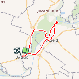
Ruta Senderismo de 11 km a descubrir en Gran Este, Ardenas, Avaux. Esta ruta ha sido propuesta por mick211.
Descripción
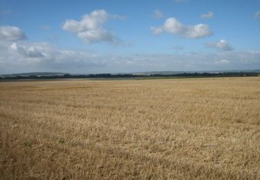
Rando le long du canal et de la rivière Aisne.
Depart Avaux
A voire: Arrivé a l'écluse traverser le pont à gauche, aller jusque au bord de la riviere (barrage)
Petite Chapelle a l'entrée d'Asfeld sur le chemin du retour.
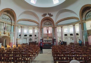
Ne pas rater Eglise St Didier construction de style unique au monde
Localización
País:
France
Región :
Gran Este
Departamento/provincia :
Ardenas
Municipio :
Avaux
Localidad:
Unknown
Salida:(Dec)
Salida:(UTM)
578552 ; 5478710 (31U) N.
Comentarios
Excursiones cerca
![Excursión Senderismo Vieux-lès-Asfeld - Chemin de Compostelle, Voie de Vézelay GR654® De Vieux lès Asfeld à Reims - Photo](https://media.geolcdn.com/t/375/260/ext.jpg?maxdim=2&url=https%3A%2F%2Fservices.sitytrail.com%2FGeolivesWS%2FDownloadMedia.ashx%3FTrailID%3D109400%26Media%3D3731_1.jpg)
![Senderismo Senderismo](https://static1.geolcdn.com/sitytour/trail-icons/101.png)
Chemin de Compostelle, Voie de Vézelay GR654® De Vieux lès Asfeld à Reims
Senderismo
Difícil
Vieux-lès-Asfeld,
Gran Este,
Ardenas,
France
![](/images/other/stat-length.png)
26 km | 28 km-effort
5h 15min
![](https://static1.geolcdn.com/siteimages/upload/files/16400158638029165_repeat_loop_refresh_sync_direction_icon.png)
No
![Excursión Senderismo Vieux-lès-Asfeld - 23_08_2024_Vieux les Asfeld - Photo](https://media.geolcdn.com/t/375/260/e1b82c5b-e96f-4be0-bff2-db08cf3ee224.jpg&format=jpg&maxdim=2)
![Senderismo Senderismo](https://static1.geolcdn.com/sitytour/trail-icons/101.png)
23_08_2024_Vieux les Asfeld
Senderismo
Medio
Vieux-lès-Asfeld,
Gran Este,
Ardenas,
France
![](/images/other/stat-length.png)
8,6 km | 9,2 km-effort
2h 5min
![](https://static1.geolcdn.com/siteimages/upload/files/16400158638029165_repeat_loop_refresh_sync_direction_icon.png)
Sí
![Excursión Senderismo Asfeld - Asfeld- Vieux les Asfeld A-R - Photo](https://media.geolcdn.com/t/375/260/ext.jpg?maxdim=2&url=https%3A%2F%2Fstatic1.geolcdn.com%2Fsiteimages%2Fupload%2Ffiles%2F1553511878bg_sport_marche.png)
![Senderismo Senderismo](https://static1.geolcdn.com/sitytour/trail-icons/101.png)
Asfeld- Vieux les Asfeld A-R
Senderismo
Muy fácil
(1)
Asfeld,
Gran Este,
Ardenas,
France
![](/images/other/stat-length.png)
7,2 km | 7,8 km-effort
1h 44min
![](https://static1.geolcdn.com/siteimages/upload/files/16400158638029165_repeat_loop_refresh_sync_direction_icon.png)
Sí
![Excursión Senderismo Avaux - Avaux-Asfeld AR - Photo](https://media.geolcdn.com/t/375/260/ext.jpg?maxdim=2&url=https%3A%2F%2Fstatic1.geolcdn.com%2Fsiteimages%2Fupload%2Ffiles%2F1553511878bg_sport_marche.png)
![Senderismo Senderismo](https://static1.geolcdn.com/sitytour/trail-icons/101.png)
Avaux-Asfeld AR
Senderismo
Muy fácil
Avaux,
Gran Este,
Ardenas,
France
![](/images/other/stat-length.png)
11 km | 12 km-effort
2h 40min
![](https://static1.geolcdn.com/siteimages/upload/files/16400158638029165_repeat_loop_refresh_sync_direction_icon.png)
Sí