![](/images/other/stat-length.png)
![Excursión Senderismo Cuiseaux - Cuiseaux Circuit du Revermont Martine page 149 - Photo](https://media.geolcdn.com/t/1900/400/c4174d4a-6ece-4da4-9070-9fdd7279a248.jpg&format=pjpeg&maxdim=2)
Cuiseaux Circuit du Revermont Martine page 149
grasgilbert
Usuario
![Longitud](/images/other/stat-length.png)
Longitud
15,8 km
![Altitud máxima](https://static1.geolcdn.com/siteimages/upload/files/1508320355ic_sort_altitude_max_24dp.png)
Altitud máxima
638 m
![Desnivel positivo](https://static1.geolcdn.com/siteimages/upload/files/1508320355ic_sort_den_pos_24dp.png)
Desnivel positivo
672 m
![Km-Effort](/images/other/stat-length.png)
Km-Effort
25 km
![Altitud mínima](https://static1.geolcdn.com/siteimages/upload/files/1508320355ic_sort_altitude_min_24dp.png)
Altitud mínima
245 m
![Desnivel negativo](https://static1.geolcdn.com/siteimages/upload/files/1508320355ic_sort_den_neg_24dp.png)
Desnivel negativo
671 m
![Boucle](https://static1.geolcdn.com/siteimages/upload/files/16400158638029165_repeat_loop_refresh_sync_direction_icon.png)
Boucle
Sí
Fecha de creación :
2024-08-22 07:31:29.562
Última modificación :
2024-08-22 16:35:53.174
![Senderismo](https://static1.geolcdn.com/sitytour/trail-icons/101.png)
5h37
Dificultad : Muy difícil
![Escanee este código QR para abrir la excursión en la aplicación SityTrail](https://capi.geolives.com/qq0zvz2zws4bq2lad0pu/sitytour/trails/4164779/qr.png?size=200)
Aplicación GPS de excursión GRATIS
A propósito
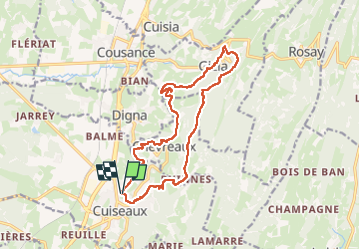
Ruta Senderismo de 15,8 km a descubrir en Borgoña-Franco Condado, Saona y Loira, Cuiseaux. Esta ruta ha sido propuesta por grasgilbert.
Descripción
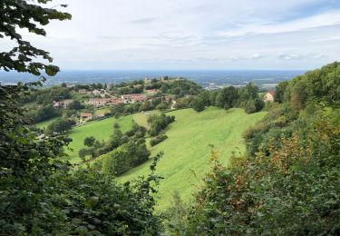
très belle rando pour marcheurs avertis
Faire en journée pour monter le matin à la fraîcheur
Localización
País:
France
Región :
Borgoña-Franco Condado
Departamento/provincia :
Saona y Loira
Municipio :
Cuiseaux
Localidad:
Unknown
Salida:(Dec)
Salida:(UTM)
683379 ; 5152142 (31T) N.
Comentarios
Excursiones cerca
![Excursión Senderismo Joudes - joudes - Photo](https://media.geolcdn.com/t/375/260/95946f55-9b1f-45be-82a2-58c0457563fe.jpg&format=jpg&maxdim=2)
![Senderismo Senderismo](https://static1.geolcdn.com/sitytour/trail-icons/101.png)
joudes
Senderismo
Medio
Joudes,
Borgoña-Franco Condado,
Saona y Loira,
France
![](/images/other/stat-length.png)
7,9 km | 11 km-effort
2h 7min
![](https://static1.geolcdn.com/siteimages/upload/files/16400158638029165_repeat_loop_refresh_sync_direction_icon.png)
Sí
![Excursión Senderismo Balanod - Balanod - Photo](https://media.geolcdn.com/t/375/260/7504aff0-c98d-4fb4-b775-4bd172ffcc3c.jpg&format=jpg&maxdim=2)
![Senderismo Senderismo](https://static1.geolcdn.com/sitytour/trail-icons/101.png)
Balanod
Senderismo
Muy fácil
Balanod,
Borgoña-Franco Condado,
Jura,
France
![](/images/other/stat-length.png)
10,4 km | 14,8 km-effort
2h 39min
![](https://static1.geolcdn.com/siteimages/upload/files/16400158638029165_repeat_loop_refresh_sync_direction_icon.png)
Sí
![Excursión Senderismo Gizia - Gizia la reculée de Gizia page159 - Photo](https://media.geolcdn.com/t/375/260/624a8c8a-bde7-4c91-9949-24379532ec9e.jpg&format=jpg&maxdim=2)
![Senderismo Senderismo](https://static1.geolcdn.com/sitytour/trail-icons/101.png)
Gizia la reculée de Gizia page159
Senderismo
Difícil
Gizia,
Borgoña-Franco Condado,
Jura,
France
![](/images/other/stat-length.png)
17,9 km | 25 km-effort
5h 10min
![](https://static1.geolcdn.com/siteimages/upload/files/16400158638029165_repeat_loop_refresh_sync_direction_icon.png)
Sí
![Excursión Senderismo Balanod - balanod - Photo](https://media.geolcdn.com/t/375/260/88ccfaba-74ae-42cf-848c-f8dc60c42f40.jpg&format=jpg&maxdim=2)
![Senderismo Senderismo](https://static1.geolcdn.com/sitytour/trail-icons/101.png)
balanod
Senderismo
Difícil
(1)
Balanod,
Borgoña-Franco Condado,
Jura,
France
![](/images/other/stat-length.png)
11,3 km | 16,2 km-effort
2h 58min
![](https://static1.geolcdn.com/siteimages/upload/files/16400158638029165_repeat_loop_refresh_sync_direction_icon.png)
Sí
![Excursión Senderismo Cuiseaux - Cuiseaux Chevreaux par la tour Hertzienne - Photo](https://media.geolcdn.com/t/375/260/730cefb0-68b0-44eb-8900-af7784bc0712.jpg&format=jpg&maxdim=2)
![Senderismo Senderismo](https://static1.geolcdn.com/sitytour/trail-icons/101.png)
Cuiseaux Chevreaux par la tour Hertzienne
Senderismo
Fácil
Cuiseaux,
Borgoña-Franco Condado,
Saona y Loira,
France
![](/images/other/stat-length.png)
10,9 km | 16,8 km-effort
3h 17min
![](https://static1.geolcdn.com/siteimages/upload/files/16400158638029165_repeat_loop_refresh_sync_direction_icon.png)
Sí
![Excursión Senderismo Graye-et-Charnay - Graye en sous-bois - Photo](https://media.geolcdn.com/t/375/260/ext.jpg?maxdim=2&url=https%3A%2F%2Fstatic1.geolcdn.com%2Fsiteimages%2Fupload%2Ffiles%2F1553511878bg_sport_marche.png)
![Senderismo Senderismo](https://static1.geolcdn.com/sitytour/trail-icons/101.png)
Graye en sous-bois
Senderismo
Muy fácil
Graye-et-Charnay,
Borgoña-Franco Condado,
Jura,
France
![](/images/other/stat-length.png)
6,3 km | 8,3 km-effort
1h 42min
![](https://static1.geolcdn.com/siteimages/upload/files/16400158638029165_repeat_loop_refresh_sync_direction_icon.png)
Sí
![Excursión Senderismo Cuiseaux - cuiseau - Photo](https://media.geolcdn.com/t/375/260/ext.jpg?maxdim=2&url=https%3A%2F%2Fstatic1.geolcdn.com%2Fsiteimages%2Fupload%2Ffiles%2F1553511878bg_sport_marche.png)
![Senderismo Senderismo](https://static1.geolcdn.com/sitytour/trail-icons/101.png)
cuiseau
Senderismo
Medio
Cuiseaux,
Borgoña-Franco Condado,
Saona y Loira,
France
![](/images/other/stat-length.png)
22 km | 35 km-effort
7h 52min
![](https://static1.geolcdn.com/siteimages/upload/files/16400158638029165_repeat_loop_refresh_sync_direction_icon.png)
Sí
![Excursión Senderismo Champagnat - champagnat - Photo](https://media.geolcdn.com/t/375/260/ext.jpg?maxdim=2&url=https%3A%2F%2Fstatic1.geolcdn.com%2Fsiteimages%2Fupload%2Ffiles%2F1553511878bg_sport_marche.png)
![Senderismo Senderismo](https://static1.geolcdn.com/sitytour/trail-icons/101.png)
champagnat
Senderismo
Difícil
Champagnat,
Borgoña-Franco Condado,
Saona y Loira,
France
![](/images/other/stat-length.png)
11,7 km | 16,6 km-effort
2h 51min
![](https://static1.geolcdn.com/siteimages/upload/files/16400158638029165_repeat_loop_refresh_sync_direction_icon.png)
Sí
![Excursión A pie Cuiseaux - Cuiseaux - Photo](https://media.geolcdn.com/t/375/260/ext.jpg?maxdim=2&url=https%3A%2F%2Fstatic1.geolcdn.com%2Fsiteimages%2Fupload%2Ffiles%2F1545311037marcheuse_200dpi.jpg)
![A pie A pie](https://static1.geolcdn.com/sitytour/trail-icons/100.png)
Cuiseaux
A pie
Fácil
Cuiseaux,
Borgoña-Franco Condado,
Saona y Loira,
France
![](/images/other/stat-length.png)
13,2 km | 19,3 km-effort
4h 23min
![](https://static1.geolcdn.com/siteimages/upload/files/16400158638029165_repeat_loop_refresh_sync_direction_icon.png)
Sí