![](/images/other/stat-length.png)
![Excursión Senderismo Mettray - Mettray - Sentier de la Grotte aux Fées - Photo](https://media.geolcdn.com/t/1900/400/0d3020ff-602a-4622-830d-5eed4789d621.jpg&format=pjpeg&maxdim=2)
Mettray - Sentier de la Grotte aux Fées
guydu41
Usuario
![Longitud](/images/other/stat-length.png)
![Altitud máxima](https://static1.geolcdn.com/siteimages/upload/files/1508320355ic_sort_altitude_max_24dp.png)
![Desnivel positivo](https://static1.geolcdn.com/siteimages/upload/files/1508320355ic_sort_den_pos_24dp.png)
![Km-Effort](/images/other/stat-length.png)
![Altitud mínima](https://static1.geolcdn.com/siteimages/upload/files/1508320355ic_sort_altitude_min_24dp.png)
![Desnivel negativo](https://static1.geolcdn.com/siteimages/upload/files/1508320355ic_sort_den_neg_24dp.png)
![Boucle](https://static1.geolcdn.com/siteimages/upload/files/16400158638029165_repeat_loop_refresh_sync_direction_icon.png)
![Senderismo](https://static1.geolcdn.com/sitytour/trail-icons/101.png)
2h30
Dificultad : Medio
![Escanee este código QR para abrir la excursión en la aplicación SityTrail](https://capi.geolives.com/qq0zvz2zws4bq2lad0pu/sitytour/trails/4160943/qr.png?size=200)
Aplicación GPS de excursión GRATIS
A propósito
Ruta Senderismo de 9,6 km a descubrir en Centro, Indre y Loira, Mettray. Esta ruta ha sido propuesta por guydu41.
Descripción
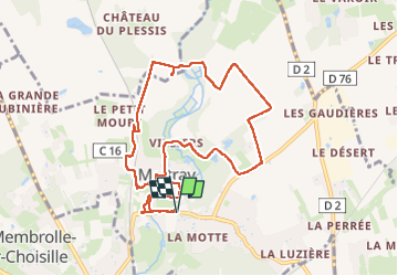
Ce circuit "balisé jaune" à parcourir en sens antihoraire commence depuis le parking "Rue des Bourgetteries" devant la grande salle de "l'Espace Cosélia", 37390 Mettray.
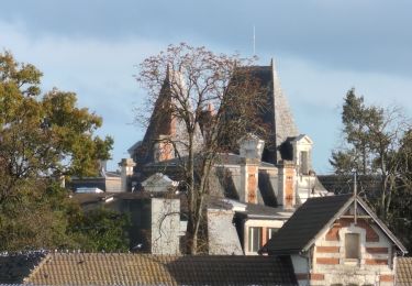
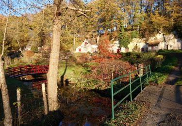
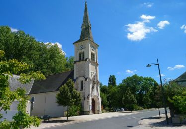
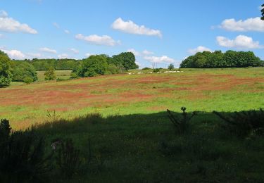
Après avoir longé la D476 sur 200 m, le parcours suit un chemin boisé longeant "la Choisille" dans un grand parc, traverse la rivière deux fois, passe devant l'Église Saint-Symphorien puis la Mairie.
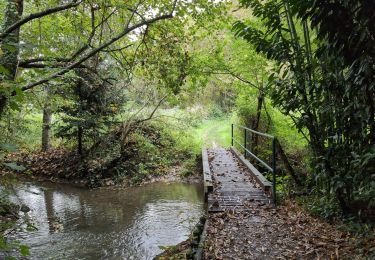
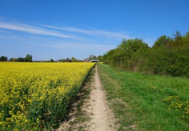
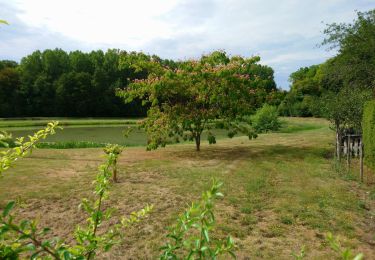
À la sortie de la ville, il franchit de nouveau "la Choisille", emprunte le "Chemin du Paradis" menant vers un bois et un plan d'eau. Ensuite il chemine à travers champs jusqu'à la Prairie d'Avantigny, suit un sentier à travers un petit bois, passe à côté de l'ancien Moulin de la Réchaussé et traverse le ruisseau "la Choisille" par un tout petit pont puis par un passage à gué.
En sortie du bois, un aller-retour mène vers l'extraordinaire Dolmen de la Grotte aux Fées. L'énorme mégalithe très bien entretenu est le plus beau de la région. Panneau explicatif sur place.
Le retour se fait en cheminant sur la "Route du Dolmen" sur 850 m, puis en quittant celle-ci par un tunnel sous la voie ferrée, longer celle-ci jusqu'à rentrer de nouveau dans le grand parc, le traverser et revenir au point de départ.
Localización
Comentarios
Excursiones cerca
![Excursión Senderismo Saint-Cyr-sur-Loire - Saint-Cyr-sur-Loire la Gagnerie - la Membrolle-sur-Choisille Mettray - 24km 405m 5h15 (50mn) - 2024 10 20 - Photo](https://media.geolcdn.com/t/375/260/21cd2b46-14f0-4eaa-a3c8-0e5f8e58cc4a.jpg&format=jpg&maxdim=2)
![Senderismo Senderismo](https://static1.geolcdn.com/sitytour/trail-icons/101.png)
Senderismo
![](/images/other/stat-length.png)
![](https://static1.geolcdn.com/siteimages/upload/files/16400158638029165_repeat_loop_refresh_sync_direction_icon.png)
![Excursión Senderismo Fondettes - Fondettes Charcenay - Sentier Val de Choisille avec variantes - 23.5km 335m 5h10 (55mn) - 2024 10 13 - Photo](https://media.geolcdn.com/t/375/260/da5cdfb1-5871-4878-b704-e11c5bcbf000.jpg&format=jpg&maxdim=2)
![Senderismo Senderismo](https://static1.geolcdn.com/sitytour/trail-icons/101.png)
Senderismo
![](/images/other/stat-length.png)
![](https://static1.geolcdn.com/siteimages/upload/files/16400158638029165_repeat_loop_refresh_sync_direction_icon.png)
![Excursión Senderismo Fondettes - Fondettes - Impro 4 communes - 21.6km 200m 4h40 (30mn) - 2021 04 24 - Photo](https://media.geolcdn.com/t/375/260/8360f715-226c-4f82-afa7-992b48458f8c.jpg&format=jpg&maxdim=2)
![Senderismo Senderismo](https://static1.geolcdn.com/sitytour/trail-icons/101.png)
Senderismo
![](/images/other/stat-length.png)
![](https://static1.geolcdn.com/siteimages/upload/files/16400158638029165_repeat_loop_refresh_sync_direction_icon.png)
![Excursión Senderismo Charentilly - Charentilly - PR la Choisillette avec variante - 9km 100m 1h50 - 2020 11 28 - Photo](https://media.geolcdn.com/t/375/260/c1b744c0-bc06-4fe5-a4fc-24f9728adfe5.jpg&format=jpg&maxdim=2)
![Senderismo Senderismo](https://static1.geolcdn.com/sitytour/trail-icons/101.png)
Senderismo
![](/images/other/stat-length.png)
![](https://static1.geolcdn.com/siteimages/upload/files/16400158638029165_repeat_loop_refresh_sync_direction_icon.png)
![Excursión Senderismo Charentilly - Charentilly - Circuit 2 avec variante - 14.8km 135m 3h05 - 2020 08 15 - Photo](https://media.geolcdn.com/t/375/260/3d2c51a1-3af7-44d8-bc0c-6a33566d6f6e.jpg&format=jpg&maxdim=2)
![Senderismo Senderismo](https://static1.geolcdn.com/sitytour/trail-icons/101.png)
Senderismo
![](/images/other/stat-length.png)
![](https://static1.geolcdn.com/siteimages/upload/files/16400158638029165_repeat_loop_refresh_sync_direction_icon.png)
![Excursión Senderismo Mettray - Mettray - Dolmen - 12.9km 160m 2h40 - 2020 07 26 - Photo](https://media.geolcdn.com/t/375/260/7eb82ac0-48df-4237-a483-c208fe4e7abd.jpg&format=jpg&maxdim=2)
![Senderismo Senderismo](https://static1.geolcdn.com/sitytour/trail-icons/101.png)
Senderismo
![](/images/other/stat-length.png)
![](https://static1.geolcdn.com/siteimages/upload/files/16400158638029165_repeat_loop_refresh_sync_direction_icon.png)
![Excursión Senderismo La Membrolle-sur-Choisille - La Membrolle-sur-Choisille - sentier Petite Choisille - 11.9km 170m 2h30 - 2020 07 24 - Photo](https://media.geolcdn.com/t/375/260/f6ef86c8-3755-4875-9651-44b6a31fd08c.jpg&format=jpg&maxdim=2)
![Senderismo Senderismo](https://static1.geolcdn.com/sitytour/trail-icons/101.png)
Senderismo
![](/images/other/stat-length.png)
![](https://static1.geolcdn.com/siteimages/upload/files/16400158638029165_repeat_loop_refresh_sync_direction_icon.png)
![Excursión Senderismo Chanceaux-sur-Choisille - Chanceaux-sur-Choisille - Sentier découverte - 14.1km 130m 2h55 - 2019 05 12 - Photo](https://media.geolcdn.com/t/375/260/bca621a1-a85c-4e84-a79a-18fb7885ed73.jpg&format=jpg&maxdim=2)
![Senderismo Senderismo](https://static1.geolcdn.com/sitytour/trail-icons/101.png)
Senderismo
![](/images/other/stat-length.png)
![](https://static1.geolcdn.com/siteimages/upload/files/16400158638029165_repeat_loop_refresh_sync_direction_icon.png)
![Excursión Senderismo Notre-Dame-d'Oé - Notre-Dame-d'Oé - PR sud - 8.8km 60m 1h50 - 2020 12 12 - Photo](https://media.geolcdn.com/t/375/260/8f00ee1e-5962-419f-92e4-b602bb673320.jpg&format=jpg&maxdim=2)
![Senderismo Senderismo](https://static1.geolcdn.com/sitytour/trail-icons/101.png)
Senderismo
![](/images/other/stat-length.png)
![](https://static1.geolcdn.com/siteimages/upload/files/16400158638029165_repeat_loop_refresh_sync_direction_icon.png)