![](/images/other/stat-length.png)
![Excursión Senderismo Plogoff - SityTrail - Tour Pointe du Raz et du Van - Cap Sizun - Photo](https://media.geolcdn.com/t/1900/400/ext.pjpeg?maxdim=2&url=https%3A%2F%2Fstatic1.geolcdn.com%2Fsiteimages%2Fupload%2Ffiles%2F1553511878bg_sport_marche.png)
SityTrail - Tour Pointe du Raz et du Van - Cap Sizun
thonyc
Usuario GUIDE
![Longitud](/images/other/stat-length.png)
Longitud
26 km
![Altitud máxima](https://static1.geolcdn.com/siteimages/upload/files/1508320355ic_sort_altitude_max_24dp.png)
Altitud máxima
79 m
![Desnivel positivo](https://static1.geolcdn.com/siteimages/upload/files/1508320355ic_sort_den_pos_24dp.png)
Desnivel positivo
558 m
![Km-Effort](/images/other/stat-length.png)
Km-Effort
34 km
![Altitud mínima](https://static1.geolcdn.com/siteimages/upload/files/1508320355ic_sort_altitude_min_24dp.png)
Altitud mínima
5 m
![Desnivel negativo](https://static1.geolcdn.com/siteimages/upload/files/1508320355ic_sort_den_neg_24dp.png)
Desnivel negativo
559 m
![Boucle](https://static1.geolcdn.com/siteimages/upload/files/16400158638029165_repeat_loop_refresh_sync_direction_icon.png)
Boucle
Sí
Fecha de creación :
2024-08-19 08:45:47.139
Última modificación :
2024-08-19 09:04:20.827
![Senderismo](https://static1.geolcdn.com/sitytour/trail-icons/101.png)
7h36
Dificultad : Difícil
![Escanee este código QR para abrir la excursión en la aplicación SityTrail](https://capi.geolives.com/qq0zvz2zws4bq2lad0pu/sitytour/trails/4160514/qr.png?size=200)
Aplicación GPS de excursión GRATIS
A propósito
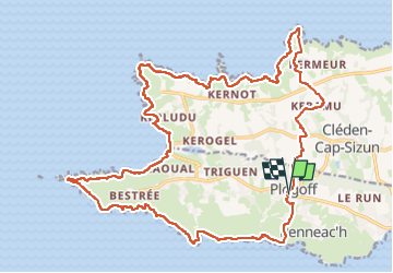
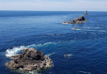
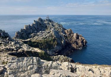
Ruta Senderismo de 26 km a descubrir en Bretaña, Finisterre, Plogoff. Esta ruta ha sido propuesta por thonyc.
Descripción
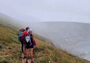
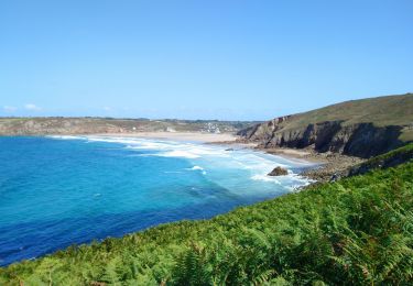
Randonnée de deux jours effectuée en février 2018. Magnifiques paysages de falaises escarpée et dentelée. Retour par des sentiers creux du cap Sizun.
Localización
País:
France
Región :
Bretaña
Departamento/provincia :
Finisterre
Municipio :
Plogoff
Localidad:
Unknown
Salida:(Dec)
Salida:(UTM)
375698 ; 5321731 (30U) N.
Comentarios
Excursiones cerca
![Excursión Senderismo Cléden-Cap-Sizun - GR34 Pointe de Brézelec -- Cléden-Cap-Sizun (Pointe du Raz) - Photo](https://media.geolcdn.com/t/375/260/c8e4b333-f389-409b-a569-fa6f65a7aa66.jpg&format=jpg&maxdim=2)
![Senderismo Senderismo](https://static1.geolcdn.com/sitytour/trail-icons/101.png)
GR34 Pointe de Brézelec -- Cléden-Cap-Sizun (Pointe du Raz)
Senderismo
Muy difícil
Cléden-Cap-Sizun,
Bretaña,
Finisterre,
France
![](/images/other/stat-length.png)
23 km | 30 km-effort
6h 54min
![](https://static1.geolcdn.com/siteimages/upload/files/16400158638029165_repeat_loop_refresh_sync_direction_icon.png)
No
![Excursión Senderismo Plogoff - TREK RCY GR34 J4 2022 Pointe du Raz/ baie des trépassés - Photo](https://media.geolcdn.com/t/375/260/5d2c6731-b703-4e85-be24-5e5d9a1ced82.jpg&format=jpg&maxdim=2)
![Senderismo Senderismo](https://static1.geolcdn.com/sitytour/trail-icons/101.png)
TREK RCY GR34 J4 2022 Pointe du Raz/ baie des trépassés
Senderismo
Fácil
Plogoff,
Bretaña,
Finisterre,
France
![](/images/other/stat-length.png)
13,9 km | 18,3 km-effort
3h 42min
![](https://static1.geolcdn.com/siteimages/upload/files/16400158638029165_repeat_loop_refresh_sync_direction_icon.png)
No
![Excursión Senderismo Cléden-Cap-Sizun - Pointe du Van - Pointe du Raz par le GR34 - 13.5km 310m 4h10 (40mn) - 2019 09 04 - Photo](https://media.geolcdn.com/t/375/260/06129bcd-1428-4839-9879-17e65208fdf9.jpg&format=jpg&maxdim=2)
![Senderismo Senderismo](https://static1.geolcdn.com/sitytour/trail-icons/101.png)
Pointe du Van - Pointe du Raz par le GR34 - 13.5km 310m 4h10 (40mn) - 2019 09 04
Senderismo
Medio
Cléden-Cap-Sizun,
Bretaña,
Finisterre,
France
![](/images/other/stat-length.png)
13,5 km | 17,6 km-effort
4h 10min
![](https://static1.geolcdn.com/siteimages/upload/files/16400158638029165_repeat_loop_refresh_sync_direction_icon.png)
Sí
![Excursión Senderismo Plogoff - la pointe du Raz - Photo](https://media.geolcdn.com/t/375/260/106b0dee-166f-4747-926b-7aeac04a59f3.jpg&format=jpg&maxdim=2)
![Senderismo Senderismo](https://static1.geolcdn.com/sitytour/trail-icons/101.png)
la pointe du Raz
Senderismo
Difícil
Plogoff,
Bretaña,
Finisterre,
France
![](/images/other/stat-length.png)
5,3 km | 7 km-effort
2h 56min
![](https://static1.geolcdn.com/siteimages/upload/files/16400158638029165_repeat_loop_refresh_sync_direction_icon.png)
Sí
![Excursión Senderismo Plogoff - plogoff loual - Photo](https://media.geolcdn.com/t/375/260/ext.jpg?maxdim=2&url=https%3A%2F%2Fstatic1.geolcdn.com%2Fsiteimages%2Fupload%2Ffiles%2F1553511878bg_sport_marche.png)
![Senderismo Senderismo](https://static1.geolcdn.com/sitytour/trail-icons/101.png)
plogoff loual
Senderismo
Fácil
(1)
Plogoff,
Bretaña,
Finisterre,
France
![](/images/other/stat-length.png)
4,1 km | 5 km-effort
1h 8min
![](https://static1.geolcdn.com/siteimages/upload/files/16400158638029165_repeat_loop_refresh_sync_direction_icon.png)
Sí
![Excursión Senderismo Plogoff - la pointe du raz Bretagne - Photo](https://media.geolcdn.com/t/375/260/ext.jpg?maxdim=2&url=https%3A%2F%2Fstatic1.geolcdn.com%2Fsiteimages%2Fupload%2Ffiles%2F1553511878bg_sport_marche.png)
![Senderismo Senderismo](https://static1.geolcdn.com/sitytour/trail-icons/101.png)
la pointe du raz Bretagne
Senderismo
Muy fácil
(1)
Plogoff,
Bretaña,
Finisterre,
France
![](/images/other/stat-length.png)
6,8 km | 9 km-effort
2h 19min
![](https://static1.geolcdn.com/siteimages/upload/files/16400158638029165_repeat_loop_refresh_sync_direction_icon.png)
Sí
![Excursión Senderismo Cléden-Cap-Sizun - point du van - Photo](https://media.geolcdn.com/t/375/260/ext.jpg?maxdim=2&url=https%3A%2F%2Fstatic1.geolcdn.com%2Fsiteimages%2Fupload%2Ffiles%2F1553511878bg_sport_marche.png)
![Senderismo Senderismo](https://static1.geolcdn.com/sitytour/trail-icons/101.png)
point du van
Senderismo
Medio
(1)
Cléden-Cap-Sizun,
Bretaña,
Finisterre,
France
![](/images/other/stat-length.png)
10,6 km | 13,9 km-effort
Desconocido
![](https://static1.geolcdn.com/siteimages/upload/files/16400158638029165_repeat_loop_refresh_sync_direction_icon.png)
Sí
![Excursión Senderismo Cléden-Cap-Sizun - Gr34 Cléden-Cap-Sizun -- Audierne - Photo](https://media.geolcdn.com/t/375/260/5b525b84-6ac9-4943-b831-b8f433338692.jpg&format=jpg&maxdim=2)
![Senderismo Senderismo](https://static1.geolcdn.com/sitytour/trail-icons/101.png)
Gr34 Cléden-Cap-Sizun -- Audierne
Senderismo
Muy difícil
Cléden-Cap-Sizun,
Bretaña,
Finisterre,
France
![](/images/other/stat-length.png)
21 km | 25 km-effort
5h 36min
![](https://static1.geolcdn.com/siteimages/upload/files/16400158638029165_repeat_loop_refresh_sync_direction_icon.png)
No
![Excursión Senderismo Cléden-Cap-Sizun - POINTE DU RAZ - Photo](https://media.geolcdn.com/t/375/260/50bf8e99-98ae-4340-8c1b-eb502686b93f.jpg&format=jpg&maxdim=2)
![Senderismo Senderismo](https://static1.geolcdn.com/sitytour/trail-icons/101.png)
POINTE DU RAZ
Senderismo
Fácil
Cléden-Cap-Sizun,
Bretaña,
Finisterre,
France
![](/images/other/stat-length.png)
15,7 km | 20 km-effort
4h 38min
![](https://static1.geolcdn.com/siteimages/upload/files/16400158638029165_repeat_loop_refresh_sync_direction_icon.png)
Sí