![](/images/other/stat-length.png)
![Excursión Senderismo Moulineaux - Foret de la londe Moulineaux - Photo](https://media.geolcdn.com/t/1900/400/ext.pjpeg?maxdim=2&url=https%3A%2F%2Fstatic1.geolcdn.com%2Fsiteimages%2Fupload%2Ffiles%2F1553511878bg_sport_marche.png)
Foret de la londe Moulineaux
27MP
Usuario
![Longitud](/images/other/stat-length.png)
Longitud
17,3 km
![Altitud máxima](https://static1.geolcdn.com/siteimages/upload/files/1508320355ic_sort_altitude_max_24dp.png)
Altitud máxima
142 m
![Desnivel positivo](https://static1.geolcdn.com/siteimages/upload/files/1508320355ic_sort_den_pos_24dp.png)
Desnivel positivo
370 m
![Km-Effort](/images/other/stat-length.png)
Km-Effort
22 km
![Altitud mínima](https://static1.geolcdn.com/siteimages/upload/files/1508320355ic_sort_altitude_min_24dp.png)
Altitud mínima
0 m
![Desnivel negativo](https://static1.geolcdn.com/siteimages/upload/files/1508320355ic_sort_den_neg_24dp.png)
Desnivel negativo
369 m
![Boucle](https://static1.geolcdn.com/siteimages/upload/files/16400158638029165_repeat_loop_refresh_sync_direction_icon.png)
Boucle
Sí
Fecha de creación :
2024-08-18 18:08:05.997
Última modificación :
2024-08-18 18:10:23.16
![Senderismo](https://static1.geolcdn.com/sitytour/trail-icons/101.png)
5h02
Dificultad : Muy difícil
![Escanee este código QR para abrir la excursión en la aplicación SityTrail](https://capi.geolives.com/qq0zvz2zws4bq2lad0pu/sitytour/trails/4160196/qr.png?size=200)
Aplicación GPS de excursión GRATIS
A propósito
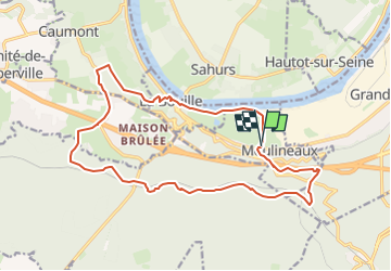
Ruta Senderismo de 17,3 km a descubrir en Normandía, Sena-Marítimo, Moulineaux. Esta ruta ha sido propuesta por 27MP.
Descripción
Depart du parking du moulin pres du stade, sentier le long de la Seine jusqu'a la Bouille, retour par la foret de la londe et le chateau de Robert le diable
Localización
País:
France
Región :
Normandía
Departamento/provincia :
Sena-Marítimo
Municipio :
Moulineaux
Localidad:
Unknown
Salida:(Dec)
Salida:(UTM)
351755 ; 5467567 (31U) N.
Comentarios
Excursiones cerca
![Excursión Senderismo Hautot-sur-Seine - Hautot-sur-seine 11km - Photo](https://media.geolcdn.com/t/375/260/2e225eeb-e814-4a2c-a540-ca57c244afd9.jpg&format=jpg&maxdim=2)
![Senderismo Senderismo](https://static1.geolcdn.com/sitytour/trail-icons/101.png)
Hautot-sur-seine 11km
Senderismo
Medio
(2)
Hautot-sur-Seine,
Normandía,
Sena-Marítimo,
France
![](/images/other/stat-length.png)
11 km | 12,2 km-effort
2h 37min
![](https://static1.geolcdn.com/siteimages/upload/files/16400158638029165_repeat_loop_refresh_sync_direction_icon.png)
Sí
![Excursión Senderismo La Londe - La Londe 76- 13 km - Photo](https://media.geolcdn.com/t/375/260/23588b19-2689-475f-b2bd-10608cbf7253.jpg&format=jpg&maxdim=2)
![Senderismo Senderismo](https://static1.geolcdn.com/sitytour/trail-icons/101.png)
La Londe 76- 13 km
Senderismo
Difícil
(1)
La Londe,
Normandía,
Sena-Marítimo,
France
![](/images/other/stat-length.png)
13 km | 16,1 km-effort
3h 43min
![](https://static1.geolcdn.com/siteimages/upload/files/16400158638029165_repeat_loop_refresh_sync_direction_icon.png)
Sí
![Excursión Senderismo Moulineaux - Robert-le-Diable - château - GD - V2 - Photo](https://media.geolcdn.com/t/375/260/ext.jpg?maxdim=2&url=https%3A%2F%2Fstatic1.geolcdn.com%2Fsiteimages%2Fupload%2Ffiles%2F1553511878bg_sport_marche.png)
![Senderismo Senderismo](https://static1.geolcdn.com/sitytour/trail-icons/101.png)
Robert-le-Diable - château - GD - V2
Senderismo
Difícil
(1)
Moulineaux,
Normandía,
Sena-Marítimo,
France
![](/images/other/stat-length.png)
10,4 km | 13,1 km-effort
2h 58min
![](https://static1.geolcdn.com/siteimages/upload/files/16400158638029165_repeat_loop_refresh_sync_direction_icon.png)
Sí
![Senderismo Senderismo](https://static1.geolcdn.com/sitytour/trail-icons/101.png)
20240507-La Londe Cool
Senderismo
Fácil
La Londe,
Normandía,
Sena-Marítimo,
France
![](/images/other/stat-length.png)
7,3 km | 9,2 km-effort
2h 15min
![](https://static1.geolcdn.com/siteimages/upload/files/16400158638029165_repeat_loop_refresh_sync_direction_icon.png)
Sí
![Senderismo Senderismo](https://static1.geolcdn.com/sitytour/trail-icons/101.png)
la londe
Senderismo
Difícil
La Londe,
Normandía,
Sena-Marítimo,
France
![](/images/other/stat-length.png)
11,6 km | 14,3 km-effort
3h 14min
![](https://static1.geolcdn.com/siteimages/upload/files/16400158638029165_repeat_loop_refresh_sync_direction_icon.png)
No
![Excursión Senderismo La Bouille - La Bouille- Cote Albert Lambert-Robert le Diable - Photo](https://media.geolcdn.com/t/375/260/6619d219-dc7a-4ef0-85ef-d79a78fa0fb8.jpg&format=jpg&maxdim=2)
![Senderismo Senderismo](https://static1.geolcdn.com/sitytour/trail-icons/101.png)
La Bouille- Cote Albert Lambert-Robert le Diable
Senderismo
Difícil
La Bouille,
Normandía,
Sena-Marítimo,
France
![](/images/other/stat-length.png)
14,9 km | 18,8 km-effort
4h 23min
![](https://static1.geolcdn.com/siteimages/upload/files/16400158638029165_repeat_loop_refresh_sync_direction_icon.png)
Sí
![Excursión Senderismo Moulineaux - 20240227-Moulineaux Cool - Photo](https://media.geolcdn.com/t/375/260/3ac6da5d-fb2e-4aeb-8862-80cdf7511849.jpg&format=jpg&maxdim=2)
![Senderismo Senderismo](https://static1.geolcdn.com/sitytour/trail-icons/101.png)
20240227-Moulineaux Cool
Senderismo
Fácil
Moulineaux,
Normandía,
Sena-Marítimo,
France
![](/images/other/stat-length.png)
7,8 km | 8,7 km-effort
1h 49min
![](https://static1.geolcdn.com/siteimages/upload/files/16400158638029165_repeat_loop_refresh_sync_direction_icon.png)
Sí
![Excursión Senderismo Sahurs - 20231216-sahurs - Photo](https://media.geolcdn.com/t/375/260/6157c822-41a3-4d46-8844-2a9e1019e224.jpg&format=jpg&maxdim=2)
![Senderismo Senderismo](https://static1.geolcdn.com/sitytour/trail-icons/101.png)
20231216-sahurs
Senderismo
Medio
Sahurs,
Normandía,
Sena-Marítimo,
France
![](/images/other/stat-length.png)
12,8 km | 14,2 km-effort
3h 18min
![](https://static1.geolcdn.com/siteimages/upload/files/16400158638029165_repeat_loop_refresh_sync_direction_icon.png)
Sí
![Excursión Senderismo Moulineaux - Robert-Le-Diable - Moulineaux - PT - V2 - Photo](https://media.geolcdn.com/t/375/260/ext.jpg?maxdim=2&url=https%3A%2F%2Fstatic1.geolcdn.com%2Fsiteimages%2Fupload%2Ffiles%2F1553511878bg_sport_marche.png)
![Senderismo Senderismo](https://static1.geolcdn.com/sitytour/trail-icons/101.png)
Robert-Le-Diable - Moulineaux - PT - V2
Senderismo
Medio
(1)
Moulineaux,
Normandía,
Sena-Marítimo,
France
![](/images/other/stat-length.png)
5,2 km | 7,2 km-effort
1h 38min
![](https://static1.geolcdn.com/siteimages/upload/files/16400158638029165_repeat_loop_refresh_sync_direction_icon.png)
Sí