![](/images/other/stat-length.png)
![Excursión Senderismo West Cork - Hungry Hill - Photo](https://media.geolcdn.com/t/1900/400/d0b58611-9340-4ec7-9d97-0e843f5725a3.jpg&format=pjpeg&maxdim=2)
Hungry Hill
Geert H.
Usuario
![Longitud](/images/other/stat-length.png)
Longitud
12,3 km
![Altitud máxima](https://static1.geolcdn.com/siteimages/upload/files/1508320355ic_sort_altitude_max_24dp.png)
Altitud máxima
679 m
![Desnivel positivo](https://static1.geolcdn.com/siteimages/upload/files/1508320355ic_sort_den_pos_24dp.png)
Desnivel positivo
624 m
![Km-Effort](/images/other/stat-length.png)
Km-Effort
21 km
![Altitud mínima](https://static1.geolcdn.com/siteimages/upload/files/1508320355ic_sort_altitude_min_24dp.png)
Altitud mínima
31 m
![Desnivel negativo](https://static1.geolcdn.com/siteimages/upload/files/1508320355ic_sort_den_neg_24dp.png)
Desnivel negativo
693 m
![Boucle](https://static1.geolcdn.com/siteimages/upload/files/16400158638029165_repeat_loop_refresh_sync_direction_icon.png)
Boucle
No
Fecha de creación :
2024-08-17 08:52:57.032
Última modificación :
2024-08-23 10:07:06.85
![Senderismo](https://static1.geolcdn.com/sitytour/trail-icons/101.png)
3h51
Dificultad : Difícil
![Escanee este código QR para abrir la excursión en la aplicación SityTrail](https://capi.geolives.com/qq0zvz2zws4bq2lad0pu/sitytour/trails/4158710/qr.png?size=200)
Aplicación GPS de excursión GRATIS
A propósito
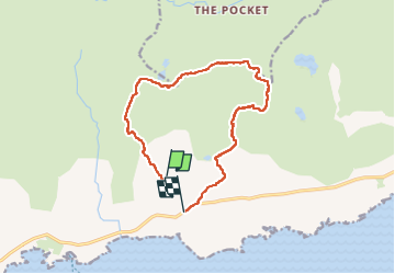
Ruta Senderismo de 12,3 km a descubrir en Desconocido, County Cork, West Cork. Esta ruta ha sido propuesta por Geert H..
Descripción
Beware, this trail is impossible to follow when the visibility is poor. The markings uphill to the top are barely visible red paint markers or stone cairns. The path from the top downhill is not marked and was followed by following the "path" on the openstreet map and GPS. But it is adventurous to say at least.
Localización
País:
Ireland
Región :
Desconocido
Departamento/provincia :
County Cork
Municipio :
West Cork
Localidad:
Curryglass
Salida:(Dec)
Salida:(UTM)
442962 ; 5724521 (29U) N.
Comentarios
Excursiones cerca
![Excursión Senderismo West Cork - All Rerrin Loop - Photo](https://media.geolcdn.com/t/375/260/ext.jpg?maxdim=2&url=https%3A%2F%2Fstatic1.geolcdn.com%2Fsiteimages%2Fupload%2Ffiles%2F1553511878bg_sport_marche.png)
![Senderismo Senderismo](https://static1.geolcdn.com/sitytour/trail-icons/101.png)
All Rerrin Loop
Senderismo
Fácil
West Cork,
Desconocido,
County Cork,
Ireland
![](/images/other/stat-length.png)
6,4 km | 7,8 km-effort
Desconocido
![](https://static1.geolcdn.com/siteimages/upload/files/16400158638029165_repeat_loop_refresh_sync_direction_icon.png)
Sí