![](/images/other/stat-length.png)
![Excursión A pie Lessard-le-National - Beauregard , autour de ses deux étangs - Photo](https://media.geolcdn.com/t/1900/400/ext.pjpeg?maxdim=2&url=https%3A%2F%2Fstatic1.geolcdn.com%2Fsiteimages%2Fupload%2Ffiles%2F1545311037marcheuse_200dpi.jpg)
Beauregard , autour de ses deux étangs
jeanpaulcheyssac
Usuario
![Longitud](/images/other/stat-length.png)
Longitud
9,8 km
![Altitud máxima](https://static1.geolcdn.com/siteimages/upload/files/1508320355ic_sort_altitude_max_24dp.png)
Altitud máxima
231 m
![Desnivel positivo](https://static1.geolcdn.com/siteimages/upload/files/1508320355ic_sort_den_pos_24dp.png)
Desnivel positivo
95 m
![Km-Effort](/images/other/stat-length.png)
Km-Effort
11 km
![Altitud mínima](https://static1.geolcdn.com/siteimages/upload/files/1508320355ic_sort_altitude_min_24dp.png)
Altitud mínima
197 m
![Desnivel negativo](https://static1.geolcdn.com/siteimages/upload/files/1508320355ic_sort_den_neg_24dp.png)
Desnivel negativo
94 m
![Boucle](https://static1.geolcdn.com/siteimages/upload/files/16400158638029165_repeat_loop_refresh_sync_direction_icon.png)
Boucle
Sí
Fecha de creación :
2024-08-14 14:18:52.502
Última modificación :
2024-10-08 13:16:05.477
![A pie](https://static1.geolcdn.com/sitytour/trail-icons/100.png)
2h30
Dificultad : Fácil
![Escanee este código QR para abrir la excursión en la aplicación SityTrail](https://capi.geolives.com/qq0zvz2zws4bq2lad0pu/sitytour/trails/4155200/qr.png?size=200)
Aplicación GPS de excursión GRATIS
A propósito
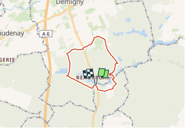
Ruta A pie de 9,8 km a descubrir en Borgoña-Franco Condado, Saona y Loira, Lessard-le-National. Esta ruta ha sido propuesta por jeanpaulcheyssac.
Descripción
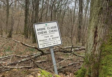
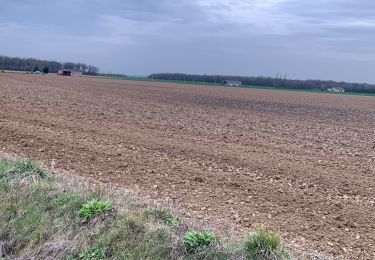
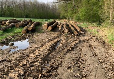
Depuis le parking du restaurant prendre le sentier derrière celui-ci et tourner dans le sens plus pour finir en longeant la route puis en traversant avant le resto .
Localización
País:
France
Región :
Borgoña-Franco Condado
Departamento/provincia :
Saona y Loira
Municipio :
Lessard-le-National
Localidad:
Unknown
Salida:(Dec)
Salida:(UTM)
641180 ; 5194831 (31T) N.
Comentarios
Excursiones cerca
![Excursión Senderismo Lessard-le-National - Demigny Beauregard Circuit des étangs page 58 - Photo](https://media.geolcdn.com/t/375/260/ext.jpg?maxdim=2&url=https%3A%2F%2Fstatic1.geolcdn.com%2Fsiteimages%2Fupload%2Ffiles%2F1553511878bg_sport_marche.png)
![Senderismo Senderismo](https://static1.geolcdn.com/sitytour/trail-icons/101.png)
Demigny Beauregard Circuit des étangs page 58
Senderismo
Difícil
Lessard-le-National,
Borgoña-Franco Condado,
Saona y Loira,
France
![](/images/other/stat-length.png)
13,6 km | 15,4 km-effort
3h 29min
![](https://static1.geolcdn.com/siteimages/upload/files/16400158638029165_repeat_loop_refresh_sync_direction_icon.png)
Sí
![Excursión Senderismo Demigny - Demigny le 21-«02-2024 - Photo](https://media.geolcdn.com/t/375/260/92116e79-cd99-4a1e-a9d3-9d2450b49d54.jpg&format=jpg&maxdim=2)
![Senderismo Senderismo](https://static1.geolcdn.com/sitytour/trail-icons/101.png)
Demigny le 21-«02-2024
Senderismo
Medio
Demigny,
Borgoña-Franco Condado,
Saona y Loira,
France
![](/images/other/stat-length.png)
10,1 km | 11,3 km-effort
2h 4min
![](https://static1.geolcdn.com/siteimages/upload/files/16400158638029165_repeat_loop_refresh_sync_direction_icon.png)
Sí
![Excursión A pie Demigny - Demigny Beauregard les bois - Photo](https://media.geolcdn.com/t/375/260/ext.jpg?maxdim=2&url=https%3A%2F%2Fstatic1.geolcdn.com%2Fsiteimages%2Fupload%2Ffiles%2F1545311037marcheuse_200dpi.jpg)
![A pie A pie](https://static1.geolcdn.com/sitytour/trail-icons/100.png)
Demigny Beauregard les bois
A pie
Fácil
Demigny,
Borgoña-Franco Condado,
Saona y Loira,
France
![](/images/other/stat-length.png)
9 km | 10,1 km-effort
2h 17min
![](https://static1.geolcdn.com/siteimages/upload/files/16400158638029165_repeat_loop_refresh_sync_direction_icon.png)
Sí
![Excursión Senderismo Lessard-le-National - Défriche le 29-03-2023 - Photo](https://media.geolcdn.com/t/375/260/32b3bd5e-c5c4-481e-8342-7a67fa99ff6e.jpg&format=jpg&maxdim=2)
![Senderismo Senderismo](https://static1.geolcdn.com/sitytour/trail-icons/101.png)
Défriche le 29-03-2023
Senderismo
Fácil
Lessard-le-National,
Borgoña-Franco Condado,
Saona y Loira,
France
![](/images/other/stat-length.png)
2,9 km | 3,4 km-effort
34min
![](https://static1.geolcdn.com/siteimages/upload/files/16400158638029165_repeat_loop_refresh_sync_direction_icon.png)
No
![Excursión Senderismo Virey-le-Grand - saint ar HBO - Photo](https://media.geolcdn.com/t/375/260/ext.jpg?maxdim=2&url=https%3A%2F%2Fstatic1.geolcdn.com%2Fsiteimages%2Fupload%2Ffiles%2F1553511878bg_sport_marche.png)
![Senderismo Senderismo](https://static1.geolcdn.com/sitytour/trail-icons/101.png)
saint ar HBO
Senderismo
Muy difícil
Virey-le-Grand,
Borgoña-Franco Condado,
Saona y Loira,
France
![](/images/other/stat-length.png)
85 km | 102 km-effort
4h 3min
![](https://static1.geolcdn.com/siteimages/upload/files/16400158638029165_repeat_loop_refresh_sync_direction_icon.png)
Sí
![Excursión Senderismo Virey-le-Grand - Défriche le 11-04-2022 - Photo](https://media.geolcdn.com/t/375/260/c1d95a93-5c63-4add-8c16-b9ed8d55c13b.jpg&format=jpg&maxdim=2)
![Senderismo Senderismo](https://static1.geolcdn.com/sitytour/trail-icons/101.png)
Défriche le 11-04-2022
Senderismo
Medio
Virey-le-Grand,
Borgoña-Franco Condado,
Saona y Loira,
France
![](/images/other/stat-length.png)
5,5 km | 6,4 km-effort
1h 2min
![](https://static1.geolcdn.com/siteimages/upload/files/16400158638029165_repeat_loop_refresh_sync_direction_icon.png)
Sí
![Excursión Senderismo Demigny - Circuit découverte de Demigny - Photo](https://media.geolcdn.com/t/375/260/ext.jpg?maxdim=2&url=https%3A%2F%2Fstatic1.geolcdn.com%2Fsiteimages%2Fupload%2Ffiles%2F1553511878bg_sport_marche.png)
![Senderismo Senderismo](https://static1.geolcdn.com/sitytour/trail-icons/101.png)
Circuit découverte de Demigny
Senderismo
Medio
Demigny,
Borgoña-Franco Condado,
Saona y Loira,
France
![](/images/other/stat-length.png)
16 km | 17,8 km-effort
4h 2min
![](https://static1.geolcdn.com/siteimages/upload/files/16400158638029165_repeat_loop_refresh_sync_direction_icon.png)
Sí
![Excursión Senderismo Demigny - Circuit des sept étangs à Demigny - Photo](https://media.geolcdn.com/t/375/260/ext.jpg?maxdim=2&url=https%3A%2F%2Fstatic1.geolcdn.com%2Fsiteimages%2Fupload%2Ffiles%2F1553511878bg_sport_marche.png)
![Senderismo Senderismo](https://static1.geolcdn.com/sitytour/trail-icons/101.png)
Circuit des sept étangs à Demigny
Senderismo
Medio
Demigny,
Borgoña-Franco Condado,
Saona y Loira,
France
![](/images/other/stat-length.png)
13,7 km | 15,5 km-effort
3h 31min
![](https://static1.geolcdn.com/siteimages/upload/files/16400158638029165_repeat_loop_refresh_sync_direction_icon.png)
Sí
![Excursión Senderismo Demigny - grande-boucle - Photo](https://media.geolcdn.com/t/375/260/ext.jpg?maxdim=2&url=https%3A%2F%2Fstatic1.geolcdn.com%2Fsiteimages%2Fupload%2Ffiles%2F1553511878bg_sport_marche.png)
![Senderismo Senderismo](https://static1.geolcdn.com/sitytour/trail-icons/101.png)
grande-boucle
Senderismo
Muy fácil
Demigny,
Borgoña-Franco Condado,
Saona y Loira,
France
![](/images/other/stat-length.png)
20 km | 23 km-effort
Desconocido
![](https://static1.geolcdn.com/siteimages/upload/files/16400158638029165_repeat_loop_refresh_sync_direction_icon.png)
Sí