![](/images/other/stat-length.png)
![Excursión Senderismo Saint-Rémy-de-Maurienne - Pic du Frêne - Photo](https://media.geolcdn.com/t/1900/400/ext.pjpeg?maxdim=2&url=https%3A%2F%2Fstatic1.geolcdn.com%2Fsiteimages%2Fupload%2Ffiles%2F1553511878bg_sport_marche.png)
Pic du Frêne
loicthev
Usuario
![Longitud](/images/other/stat-length.png)
Longitud
14 km
![Altitud máxima](https://static1.geolcdn.com/siteimages/upload/files/1508320355ic_sort_altitude_max_24dp.png)
Altitud máxima
2766 m
![Desnivel positivo](https://static1.geolcdn.com/siteimages/upload/files/1508320355ic_sort_den_pos_24dp.png)
Desnivel positivo
1677 m
![Km-Effort](/images/other/stat-length.png)
Km-Effort
36 km
![Altitud mínima](https://static1.geolcdn.com/siteimages/upload/files/1508320355ic_sort_altitude_min_24dp.png)
Altitud mínima
1087 m
![Desnivel negativo](https://static1.geolcdn.com/siteimages/upload/files/1508320355ic_sort_den_neg_24dp.png)
Desnivel negativo
1673 m
![Boucle](https://static1.geolcdn.com/siteimages/upload/files/16400158638029165_repeat_loop_refresh_sync_direction_icon.png)
Boucle
Sí
Fecha de creación :
2024-08-10 05:45:52.232
Última modificación :
2024-08-10 18:08:54.42
![Senderismo](https://static1.geolcdn.com/sitytour/trail-icons/101.png)
5h15
Dificultad : Difícil
![Escanee este código QR para abrir la excursión en la aplicación SityTrail](https://capi.geolives.com/qq0zvz2zws4bq2lad0pu/sitytour/trails/4151236/qr.png?size=200)
Aplicación GPS de excursión GRATIS
A propósito
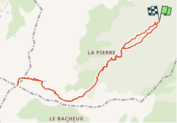
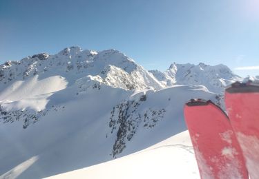
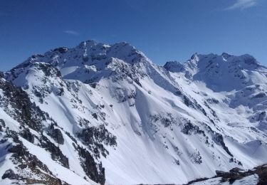
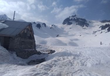
Ruta Senderismo de 14 km a descubrir en Auvergne-Rhône-Alpes, Saboya, Saint-Rémy-de-Maurienne. Esta ruta ha sido propuesta por loicthev.
Descripción
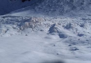
Randonnée au Pic du Frêne
Chalet de lescherette > Lac de la Vallette > Col de la Vallette > Pic du Frêne
10/08/2024
Alexandre Guillaume Loïc
Localización
País:
France
Región :
Auvergne-Rhône-Alpes
Departamento/provincia :
Saboya
Municipio :
Saint-Rémy-de-Maurienne
Localidad:
Unknown
Salida:(Dec)
Salida:(UTM)
284469 ; 5027548 (32T) N.
Comentarios
Excursiones cerca
![Excursión Esquí de fondo Saint-Rémy-de-Maurienne - Le Grand Miceau - Photo](https://media.geolcdn.com/t/375/260/552c0109-7b27-4a1b-8c35-21254f7ae1b7.jpg&format=jpg&maxdim=2)
![Esquí de fondo Esquí de fondo](https://static1.geolcdn.com/sitytour/trail-icons/503.png)
Le Grand Miceau
Esquí de fondo
Difícil
Saint-Rémy-de-Maurienne,
Auvergne-Rhône-Alpes,
Saboya,
France
![](/images/other/stat-length.png)
10,5 km | 30 km-effort
5h 34min
![](https://static1.geolcdn.com/siteimages/upload/files/16400158638029165_repeat_loop_refresh_sync_direction_icon.png)
Sí
![Excursión Esquí de fondo Saint-Rémy-de-Maurienne - Tentative du Grand Miceau - Photo](https://media.geolcdn.com/t/375/260/ed1adf38-dc3e-452e-8e6c-31407f3dafc1.jpg&format=jpg&maxdim=2)
![Esquí de fondo Esquí de fondo](https://static1.geolcdn.com/sitytour/trail-icons/503.png)
Tentative du Grand Miceau
Esquí de fondo
Medio
Saint-Rémy-de-Maurienne,
Auvergne-Rhône-Alpes,
Saboya,
France
![](/images/other/stat-length.png)
9,8 km | 27 km-effort
4h 26min
![](https://static1.geolcdn.com/siteimages/upload/files/16400158638029165_repeat_loop_refresh_sync_direction_icon.png)
Sí
![Excursión Esquí de fondo Saint-Rémy-de-Maurienne - col de la pierre et plus - Photo](https://media.geolcdn.com/t/375/260/60fdb9cb-9796-45a2-8a0b-4a568cf87f78.jpg&format=jpg&maxdim=2)
![Esquí de fondo Esquí de fondo](https://static1.geolcdn.com/sitytour/trail-icons/503.png)
col de la pierre et plus
Esquí de fondo
Medio
Saint-Rémy-de-Maurienne,
Auvergne-Rhône-Alpes,
Saboya,
France
![](/images/other/stat-length.png)
12,7 km | 34 km-effort
6h 0min
![](https://static1.geolcdn.com/siteimages/upload/files/16400158638029165_repeat_loop_refresh_sync_direction_icon.png)
Sí
![Excursión Esquí de fondo Saint-Rémy-de-Maurienne - la grande Moutonnière - Photo](https://media.geolcdn.com/t/375/260/4f62b340-bee1-4fa3-b256-acc9fb712bdf.jpg&format=jpg&maxdim=2)
![Esquí de fondo Esquí de fondo](https://static1.geolcdn.com/sitytour/trail-icons/503.png)
la grande Moutonnière
Esquí de fondo
Fácil
Saint-Rémy-de-Maurienne,
Auvergne-Rhône-Alpes,
Saboya,
France
![](/images/other/stat-length.png)
9,4 km | 24 km-effort
4h 10min
![](https://static1.geolcdn.com/siteimages/upload/files/16400158638029165_repeat_loop_refresh_sync_direction_icon.png)
Sí
![Excursión Esquí de fondo Saint-Rémy-de-Maurienne - Tête de la Laperrière et grosse Tête - Photo](https://media.geolcdn.com/t/375/260/2f646ed5-fb79-4354-9708-4cdda3e358f6.jpg&format=jpg&maxdim=2)
![Esquí de fondo Esquí de fondo](https://static1.geolcdn.com/sitytour/trail-icons/503.png)
Tête de la Laperrière et grosse Tête
Esquí de fondo
Medio
Saint-Rémy-de-Maurienne,
Auvergne-Rhône-Alpes,
Saboya,
France
![](/images/other/stat-length.png)
13,6 km | 33 km-effort
6h 8min
![](https://static1.geolcdn.com/siteimages/upload/files/16400158638029165_repeat_loop_refresh_sync_direction_icon.png)
Sí
![Excursión Esquí de fondo Saint-Rémy-de-Maurienne - pré Charvin - Photo](https://media.geolcdn.com/t/375/260/e6f3a144-6c44-4b0a-82f9-48282c037467.jpg&format=jpg&maxdim=2)
![Esquí de fondo Esquí de fondo](https://static1.geolcdn.com/sitytour/trail-icons/503.png)
pré Charvin
Esquí de fondo
Medio
Saint-Rémy-de-Maurienne,
Auvergne-Rhône-Alpes,
Saboya,
France
![](/images/other/stat-length.png)
10,9 km | 27 km-effort
5h 19min
![](https://static1.geolcdn.com/siteimages/upload/files/16400158638029165_repeat_loop_refresh_sync_direction_icon.png)
Sí
![Excursión Esquí de fondo Saint-Rémy-de-Maurienne - la grande moutonnière, et Grosse tête - Photo](https://media.geolcdn.com/t/375/260/8fda1c38-381a-4b0a-9dd7-0726067b7f14.jpg&format=jpg&maxdim=2)
![Esquí de fondo Esquí de fondo](https://static1.geolcdn.com/sitytour/trail-icons/503.png)
la grande moutonnière, et Grosse tête
Esquí de fondo
Medio
Saint-Rémy-de-Maurienne,
Auvergne-Rhône-Alpes,
Saboya,
France
![](/images/other/stat-length.png)
12,3 km | 30 km-effort
6h 32min
![](https://static1.geolcdn.com/siteimages/upload/files/16400158638029165_repeat_loop_refresh_sync_direction_icon.png)
Sí
![Excursión Esquí de fondo Saint-Rémy-de-Maurienne - La tête de la perrière et Pré Charvin - Photo](https://media.geolcdn.com/t/375/260/8b3331eb-6fcb-40a0-a8aa-0f7a86675237.jpg&format=jpg&maxdim=2)
![Esquí de fondo Esquí de fondo](https://static1.geolcdn.com/sitytour/trail-icons/503.png)
La tête de la perrière et Pré Charvin
Esquí de fondo
Medio
Saint-Rémy-de-Maurienne,
Auvergne-Rhône-Alpes,
Saboya,
France
![](/images/other/stat-length.png)
14,9 km | 34 km-effort
6h 41min
![](https://static1.geolcdn.com/siteimages/upload/files/16400158638029165_repeat_loop_refresh_sync_direction_icon.png)
Sí
![Excursión Esquí de fondo Saint-Rémy-de-Maurienne - col de la Valette - Photo](https://media.geolcdn.com/t/375/260/57a078c9-9933-40f7-b6a3-6465f4504a2e.jpg&format=jpg&maxdim=2)
![Esquí de fondo Esquí de fondo](https://static1.geolcdn.com/sitytour/trail-icons/503.png)
col de la Valette
Esquí de fondo
Difícil
Saint-Rémy-de-Maurienne,
Auvergne-Rhône-Alpes,
Saboya,
France
![](/images/other/stat-length.png)
14,4 km | 37 km-effort
6h 25min
![](https://static1.geolcdn.com/siteimages/upload/files/16400158638029165_repeat_loop_refresh_sync_direction_icon.png)
Sí