![](/images/other/stat-length.png)
![Excursión Senderismo Saint-Pierre-de-la-Fage - St-Pierre-de-la-Fage-7,8kmx180m - Photo](https://media.geolcdn.com/t/1900/400/ext.pjpeg?maxdim=2&url=https%3A%2F%2Fstatic1.geolcdn.com%2Fsiteimages%2Fupload%2Ffiles%2F1553511878bg_sport_marche.png)
St-Pierre-de-la-Fage-7,8kmx180m
bernard.calvie
Usuario
![Longitud](/images/other/stat-length.png)
![Altitud máxima](https://static1.geolcdn.com/siteimages/upload/files/1508320355ic_sort_altitude_max_24dp.png)
![Desnivel positivo](https://static1.geolcdn.com/siteimages/upload/files/1508320355ic_sort_den_pos_24dp.png)
![Km-Effort](/images/other/stat-length.png)
![Altitud mínima](https://static1.geolcdn.com/siteimages/upload/files/1508320355ic_sort_altitude_min_24dp.png)
![Desnivel negativo](https://static1.geolcdn.com/siteimages/upload/files/1508320355ic_sort_den_neg_24dp.png)
![Boucle](https://static1.geolcdn.com/siteimages/upload/files/16400158638029165_repeat_loop_refresh_sync_direction_icon.png)
![Senderismo](https://static1.geolcdn.com/sitytour/trail-icons/101.png)
2h19
Dificultad : Medio
![Escanee este código QR para abrir la excursión en la aplicación SityTrail](https://capi.geolives.com/qq0zvz2zws4bq2lad0pu/sitytour/trails/4150683/qr.png?size=200)
Aplicación GPS de excursión GRATIS
A propósito
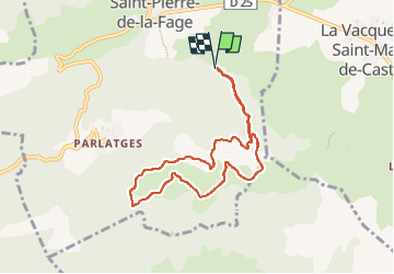
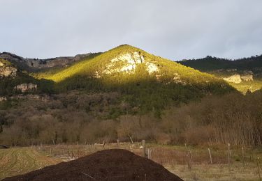
Ruta Senderismo de 7,8 km a descubrir en Occitania, Hérault, Saint-Pierre-de-la-Fage. Esta ruta ha sido propuesta por bernard.calvie.
Descripción
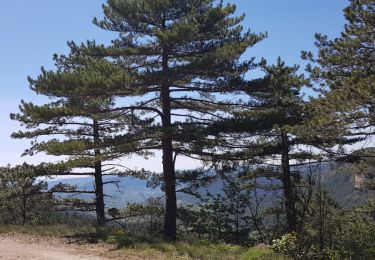
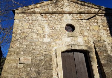
A partir de Saint-Pierre-de-la-Fage, après avoir contourné la très belle petite chapelle, on rejoint la piste (encore carrossable) qui longe le "Plan de Saint-Pierre" en direction du "Pas de Cabane". Une aire de stationnement est offerte là aux marcheurs.
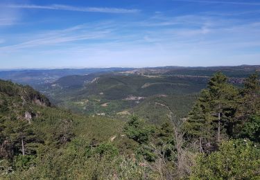
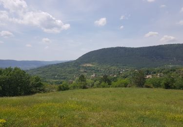
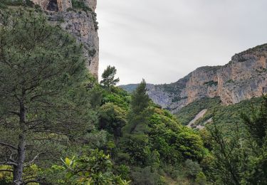
On aborde ainsi directement un petit circuit dans la forêt de Notre-Dame-de-Parlatges au cœur de l'hiver, sur la neige et dans la brume... mais heureusement à l'abri (relatif) des assauts furieux du vent en cette fin janvier: une autre vision de ces paysages grandioses, avec un beau manteau de neige et un froid vif qui stimule les marcheurs. Sur la piste, régulière, ne sont visibles que les traces des sangliers et des renards. L'aller, à flanc de montagne, fait face au Cirque du Bout-du-Monde, et le retour, sur l'autre versant, emprunte un segment du GR7.
Un beau souvenir, et la satisfaction d'avoir résisté à la tentation de rester au chaud pour vivre cette expérience vivifiante !
Localización
Comentarios
Excursiones cerca
![Excursión Senderismo Saint-Étienne-de-Gourgas - St Etienne de Gourgas - col de Melanque - Puech haut - Photo](https://media.geolcdn.com/t/375/260/ext.jpg?maxdim=2&url=https%3A%2F%2Fservices.sitytrail.com%2FGeolivesWS%2FDownloadMedia.ashx%3FTrailID%3D334032%26Media%3Decee9542-ae6c-4b78-860f-f4fbe993ce14.jpg)
![Senderismo Senderismo](https://static1.geolcdn.com/sitytour/trail-icons/101.png)
Senderismo
![](/images/other/stat-length.png)
![](https://static1.geolcdn.com/siteimages/upload/files/16400158638029165_repeat_loop_refresh_sync_direction_icon.png)
![Excursión Senderismo Saint-Pierre-de-la-Fage - Parlatges - La Vacquerie-et-St-Martin-de-Castries - Photo](https://media.geolcdn.com/t/375/260/076ea1bb-8acb-4fc6-bfb0-1a2a8946e2fc.jpg&format=jpg&maxdim=2)
![Senderismo Senderismo](https://static1.geolcdn.com/sitytour/trail-icons/101.png)
Senderismo
![](/images/other/stat-length.png)
![](https://static1.geolcdn.com/siteimages/upload/files/16400158638029165_repeat_loop_refresh_sync_direction_icon.png)
![Excursión Senderismo Saint-Étienne-de-Gourgas - Le cirque du Bout-du-Monde - Photo](https://media.geolcdn.com/t/375/260/ext.jpg?maxdim=2&url=https%3A%2F%2Fservices.sitytrail.com%2FGeolivesWS%2FDownloadMedia.ashx%3FTrailID%3D206744%26Media%3Dfix__20130721140204.jpg)
![Senderismo Senderismo](https://static1.geolcdn.com/sitytour/trail-icons/101.png)
Senderismo
![](/images/other/stat-length.png)
![](https://static1.geolcdn.com/siteimages/upload/files/16400158638029165_repeat_loop_refresh_sync_direction_icon.png)
![Excursión Marcha nórdica Saint-Pierre-de-la-Fage - SityTrail - St-Pierre de la Fage - Pas de Cabane - Roqueboude - Photo](https://media.geolcdn.com/t/375/260/f3de2af3-46a7-4008-bd2a-646a63c35c72.jpg&format=jpg&maxdim=2)
![Marcha nórdica Marcha nórdica](https://static1.geolcdn.com/sitytour/trail-icons/102.png)
Marcha nórdica
![](/images/other/stat-length.png)
![](https://static1.geolcdn.com/siteimages/upload/files/16400158638029165_repeat_loop_refresh_sync_direction_icon.png)
![Excursión Marcha nórdica Saint-Pierre-de-la-Fage - St-Pierre de la Fage - Pas de Cabane - Roqueboude - Photo](https://media.geolcdn.com/t/375/260/b0257bf0-1019-48a4-89d5-956e560fc262.jpg&format=jpg&maxdim=2)
![Marcha nórdica Marcha nórdica](https://static1.geolcdn.com/sitytour/trail-icons/102.png)
Marcha nórdica
![](/images/other/stat-length.png)
![](https://static1.geolcdn.com/siteimages/upload/files/16400158638029165_repeat_loop_refresh_sync_direction_icon.png)
![Marcha nórdica Marcha nórdica](https://static1.geolcdn.com/sitytour/trail-icons/102.png)
Marcha nórdica
![](/images/other/stat-length.png)
![](https://static1.geolcdn.com/siteimages/upload/files/16400158638029165_repeat_loop_refresh_sync_direction_icon.png)
![Excursión Senderismo La Vacquerie-et-Saint-Martin-de-Castries - La Vacquerie St Guilhem - Photo](https://media.geolcdn.com/t/375/260/6776b6fa-32bb-4389-aa74-60e92a5ab663.jpg&format=jpg&maxdim=2)
![Senderismo Senderismo](https://static1.geolcdn.com/sitytour/trail-icons/101.png)
Senderismo
![](/images/other/stat-length.png)
![](https://static1.geolcdn.com/siteimages/upload/files/16400158638029165_repeat_loop_refresh_sync_direction_icon.png)
![Marcha nórdica Marcha nórdica](https://static1.geolcdn.com/sitytour/trail-icons/102.png)
Marcha nórdica
![](/images/other/stat-length.png)
![](https://static1.geolcdn.com/siteimages/upload/files/16400158638029165_repeat_loop_refresh_sync_direction_icon.png)
![Excursión Marcha nórdica Saint-Étienne-de-Gourgas - Cirque du Bout du Monde - Photo](https://media.geolcdn.com/t/375/260/8b4c9041-df88-45ff-a81a-b9337b4fed4a.jpg&format=jpg&maxdim=2)
![Marcha nórdica Marcha nórdica](https://static1.geolcdn.com/sitytour/trail-icons/102.png)
Marcha nórdica
![](/images/other/stat-length.png)
![](https://static1.geolcdn.com/siteimages/upload/files/16400158638029165_repeat_loop_refresh_sync_direction_icon.png)