![](/images/other/stat-length.png)
![Excursión Lourmarin - Lourmarin- Aiguë Brun- Crète Auribeau - Photo](https://media.geolcdn.com/t/1900/400/ext.pjpeg?maxdim=2&url=https%3A%2F%2Fsecurestorage.geolives.com%2Fsitytour%2Ftrail-bg%2Fdefault.jpg)
Lourmarin- Aiguë Brun- Crète Auribeau
DG01
Usuario
![Longitud](/images/other/stat-length.png)
![Altitud máxima](https://static1.geolcdn.com/siteimages/upload/files/1508320355ic_sort_altitude_max_24dp.png)
![Desnivel positivo](https://static1.geolcdn.com/siteimages/upload/files/1508320355ic_sort_den_pos_24dp.png)
![Km-Effort](/images/other/stat-length.png)
![Altitud mínima](https://static1.geolcdn.com/siteimages/upload/files/1508320355ic_sort_altitude_min_24dp.png)
![Desnivel negativo](https://static1.geolcdn.com/siteimages/upload/files/1508320355ic_sort_den_neg_24dp.png)
![Boucle](https://static1.geolcdn.com/siteimages/upload/files/16400158638029165_repeat_loop_refresh_sync_direction_icon.png)
![Escanee este código QR para abrir la excursión en la aplicación SityTrail](https://capi.geolives.com/qq0zvz2zws4bq2lad0pu/sitytour/trails/4148608/qr.png?size=200)
Aplicación GPS de excursión GRATIS
A propósito
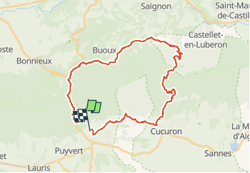
Ruta de 36 km a descubrir en Provenza-Alpes-Costa Azul, Vaucluse, Lourmarin. Esta ruta ha sido propuesta por DG01.
Descripción
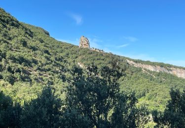
Le single remontant L’Aigue Brun est absolument fabuleux (ombragé, technique et roulant parfois et typique).
Le DFCI depuis la chapelle St Pierre n’est pas de tout repos (300m D ), mais il permet d’atteindre la crête du Grand Luberon en moins de 45min.
Le single de descente est loin d’être le meilleur du coin (végétation dense, raviné, etc…), mais la fin s’améliore jusque sous la chapelle de l’ hermitage de Cucuron.
Localización
Comentarios
Excursiones cerca
![Excursión Senderismo Buoux - PF-Buoux - Sivergues - Le Vallon de l'Aigue Brun - Reco - 01.07.2021 - Photo](https://media.geolcdn.com/t/375/260/fb3b1bc5-2125-42f3-acfd-b4dc3f708a67.jpg&format=jpg&maxdim=2)
![Senderismo Senderismo](https://static1.geolcdn.com/sitytour/trail-icons/101.png)
Senderismo
![](/images/other/stat-length.png)
![](https://static1.geolcdn.com/siteimages/upload/files/16400158638029165_repeat_loop_refresh_sync_direction_icon.png)
![Excursión Senderismo Vaugines - PF-Vaugines - Cucuron - l'Ermitage - Vaugines - 17.06.2021 - Photo](https://media.geolcdn.com/t/375/260/49a6fcb0-e7e8-4e10-aa10-ef2270b11aa9.jpg&format=jpg&maxdim=2)
![Senderismo Senderismo](https://static1.geolcdn.com/sitytour/trail-icons/101.png)
Senderismo
![](/images/other/stat-length.png)
![](https://static1.geolcdn.com/siteimages/upload/files/16400158638029165_repeat_loop_refresh_sync_direction_icon.png)
![Senderismo Senderismo](https://static1.geolcdn.com/sitytour/trail-icons/101.png)
Senderismo
![](/images/other/stat-length.png)
![](https://static1.geolcdn.com/siteimages/upload/files/16400158638029165_repeat_loop_refresh_sync_direction_icon.png)
![Excursión Senderismo Cadenet - Cadenet -Lourmarin - Photo](https://media.geolcdn.com/t/375/260/f0fee848-9372-4ead-90a1-4f47846561d2.jpg&format=jpg&maxdim=2)
![Senderismo Senderismo](https://static1.geolcdn.com/sitytour/trail-icons/101.png)
Senderismo
![](/images/other/stat-length.png)
![](https://static1.geolcdn.com/siteimages/upload/files/16400158638029165_repeat_loop_refresh_sync_direction_icon.png)
![Excursión Senderismo Buoux - 2024-03-15 Buoux - Sivergues - Photo](https://media.geolcdn.com/t/375/260/cee14782-71fc-4a90-896b-8bed906fd77c.jpg&format=jpg&maxdim=2)
![Senderismo Senderismo](https://static1.geolcdn.com/sitytour/trail-icons/101.png)
Senderismo
![](/images/other/stat-length.png)
![](https://static1.geolcdn.com/siteimages/upload/files/16400158638029165_repeat_loop_refresh_sync_direction_icon.png)
![Senderismo Senderismo](https://static1.geolcdn.com/sitytour/trail-icons/101.png)
Senderismo
![](/images/other/stat-length.png)
![](https://static1.geolcdn.com/siteimages/upload/files/16400158638029165_repeat_loop_refresh_sync_direction_icon.png)
![Excursión Senderismo Cadenet - PF-Cadenet - De Cadenet à Lourmarin - 3 - Photo](https://media.geolcdn.com/t/375/260/a6ee6e4b-3e12-4299-848e-3348098a84d0.jpg&format=jpg&maxdim=2)
![Senderismo Senderismo](https://static1.geolcdn.com/sitytour/trail-icons/101.png)
Senderismo
![](/images/other/stat-length.png)
![](https://static1.geolcdn.com/siteimages/upload/files/16400158638029165_repeat_loop_refresh_sync_direction_icon.png)
![Senderismo Senderismo](https://static1.geolcdn.com/sitytour/trail-icons/101.png)
Senderismo
![](/images/other/stat-length.png)
![](https://static1.geolcdn.com/siteimages/upload/files/16400158638029165_repeat_loop_refresh_sync_direction_icon.png)
![Excursión Senderismo Buoux - L'Aiguebrun Sivergues - Photo](https://media.geolcdn.com/t/375/260/ext.jpg?maxdim=2&url=https%3A%2F%2Fservices.sitytrail.com%2FGeolivesWS%2FDownloadMedia.ashx%3FTrailID%3D428178%26Media%3Dfix__20150531122254.jpg)
![Senderismo Senderismo](https://static1.geolcdn.com/sitytour/trail-icons/101.png)
Senderismo
![](/images/other/stat-length.png)
![](https://static1.geolcdn.com/siteimages/upload/files/16400158638029165_repeat_loop_refresh_sync_direction_icon.png)