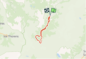
![](/images/other/stat-length.png)
![Excursión Senderismo Pralognan-la-Vanoise - Lac Blanc (refuge de Peclet-Polset) - Photo](https://media.geolcdn.com/t/1900/400/ext.pjpeg?maxdim=2&url=https%3A%2F%2Fstatic1.geolcdn.com%2Fsiteimages%2Fupload%2Ffiles%2F1553511878bg_sport_marche.png)
Lac Blanc (refuge de Peclet-Polset)
Chabard
Usuario
![Longitud](/images/other/stat-length.png)
![Altitud máxima](https://static1.geolcdn.com/siteimages/upload/files/1508320355ic_sort_altitude_max_24dp.png)
![Desnivel positivo](https://static1.geolcdn.com/siteimages/upload/files/1508320355ic_sort_den_pos_24dp.png)
![Km-Effort](/images/other/stat-length.png)
![Altitud mínima](https://static1.geolcdn.com/siteimages/upload/files/1508320355ic_sort_altitude_min_24dp.png)
![Desnivel negativo](https://static1.geolcdn.com/siteimages/upload/files/1508320355ic_sort_den_neg_24dp.png)
![Boucle](https://static1.geolcdn.com/siteimages/upload/files/16400158638029165_repeat_loop_refresh_sync_direction_icon.png)
![Senderismo](https://static1.geolcdn.com/sitytour/trail-icons/101.png)
7h11
Dificultad : Medio
![Escanee este código QR para abrir la excursión en la aplicación SityTrail](https://capi.geolives.com/qq0zvz2zws4bq2lad0pu/sitytour/trails/4146907/qr.png?size=200)
Aplicación GPS de excursión GRATIS
A propósito
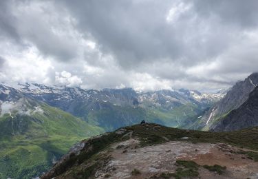
Ruta Senderismo de 20 km a descubrir en Auvergne-Rhône-Alpes, Saboya, Pralognan-la-Vanoise. Esta ruta ha sido propuesta por Chabard.
Descripción
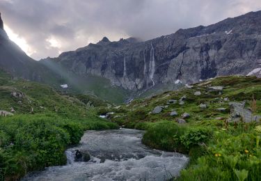
Départ du parking des Ruelles (Les Prioux)
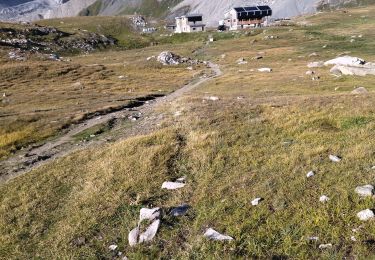
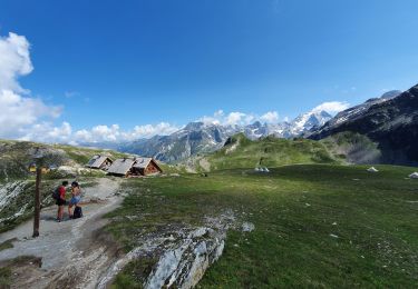
Refuge du Roc de la Pêche
Montée au Lac Blanc à partir de La Rama
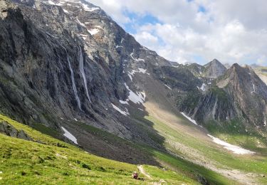
Refuge de Peclet-Polset
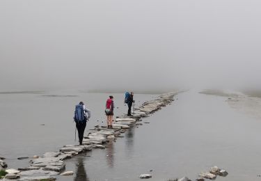
Retour en rive droite du ruisseau jusqu'au Ritord
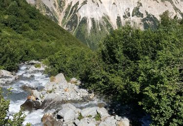
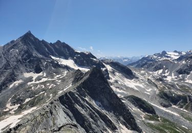
NB : randonnée sans difficulté particulière si ce n'est sa longueur (20km) mais qui vaut le coup pour ses paysages majestueux.
Localización
Comentarios
Excursiones cerca
![Excursión Senderismo Pralognan-la-Vanoise - Pralognan - Les Prioux Lac de Chalet Clou - Photo](https://media.geolcdn.com/t/375/260/aef0b6ed-57e6-4d04-a75d-d2ffe6e61cd4.jpg&format=jpg&maxdim=2)
![Senderismo Senderismo](https://static1.geolcdn.com/sitytour/trail-icons/101.png)
Senderismo
![](/images/other/stat-length.png)
![](https://static1.geolcdn.com/siteimages/upload/files/16400158638029165_repeat_loop_refresh_sync_direction_icon.png)
![Excursión Senderismo Val-Cenis - traversée Valette f faure - Photo](https://media.geolcdn.com/t/375/260/1679692e-b77c-47af-aee2-08c69ff92bec.jpg&format=jpg&maxdim=2)
![Senderismo Senderismo](https://static1.geolcdn.com/sitytour/trail-icons/101.png)
Senderismo
![](/images/other/stat-length.png)
![](https://static1.geolcdn.com/siteimages/upload/files/16400158638029165_repeat_loop_refresh_sync_direction_icon.png)
![Excursión Senderismo Pralognan-la-Vanoise - traversée des Fontanettes aux Prioux par le col du Grand marchet - Photo](https://media.geolcdn.com/t/375/260/24a33514-db38-4400-a38f-98ffcbd53fe7.jpg&format=jpg&maxdim=2)
![Senderismo Senderismo](https://static1.geolcdn.com/sitytour/trail-icons/101.png)
Senderismo
![](/images/other/stat-length.png)
![](https://static1.geolcdn.com/siteimages/upload/files/16400158638029165_repeat_loop_refresh_sync_direction_icon.png)
![Excursión Senderismo Pralognan-la-Vanoise - col de napremont - Photo](https://media.geolcdn.com/t/375/260/6fea95cc-6da2-44f1-9ef9-b36a9d856ac2.jpg&format=jpg&maxdim=2)
![Senderismo Senderismo](https://static1.geolcdn.com/sitytour/trail-icons/101.png)
Senderismo
![](/images/other/stat-length.png)
![](https://static1.geolcdn.com/siteimages/upload/files/16400158638029165_repeat_loop_refresh_sync_direction_icon.png)
![Excursión Senderismo Pralognan-la-Vanoise - 2022-06-28 Marche TGV Refuge Valette Pralognan - Photo](https://media.geolcdn.com/t/375/260/64cb2300-ba57-4fac-bb37-92f95e3da956.jpg&format=jpg&maxdim=2)
![Senderismo Senderismo](https://static1.geolcdn.com/sitytour/trail-icons/101.png)
Senderismo
![](/images/other/stat-length.png)
![](https://static1.geolcdn.com/siteimages/upload/files/16400158638029165_repeat_loop_refresh_sync_direction_icon.png)
![Excursión Senderismo Pralognan-la-Vanoise - 2022-06-24 Marche TGV Pralognan Refuge du Col de la Vanoise - Photo](https://media.geolcdn.com/t/375/260/c4f04535-b0e5-45fd-a513-c3cb8f626a13.jpg&format=jpg&maxdim=2)
![Senderismo Senderismo](https://static1.geolcdn.com/sitytour/trail-icons/101.png)
Senderismo
![](/images/other/stat-length.png)
![](https://static1.geolcdn.com/siteimages/upload/files/16400158638029165_repeat_loop_refresh_sync_direction_icon.png)
![Excursión Senderismo Pralognan-la-Vanoise - col d'Aussois et pointe de l'Observatoire - Photo](https://media.geolcdn.com/t/375/260/2fde2aa0-abdb-4870-bdd9-82be854bfe3a.jpg&format=jpg&maxdim=2)
![Senderismo Senderismo](https://static1.geolcdn.com/sitytour/trail-icons/101.png)
Senderismo
![](/images/other/stat-length.png)
![](https://static1.geolcdn.com/siteimages/upload/files/16400158638029165_repeat_loop_refresh_sync_direction_icon.png)
![Excursión Senderismo Pralognan-la-Vanoise - le refuge de La Valette (traversée) - Photo](https://media.geolcdn.com/t/375/260/426a5370-8a9e-4055-9485-926570ebee7e.jpg&format=jpg&maxdim=2)
![Senderismo Senderismo](https://static1.geolcdn.com/sitytour/trail-icons/101.png)
Senderismo
![](/images/other/stat-length.png)
![](https://static1.geolcdn.com/siteimages/upload/files/16400158638029165_repeat_loop_refresh_sync_direction_icon.png)
![Excursión Senderismo Pralognan-la-Vanoise - Le Petit Mont Blanc - Photo](https://media.geolcdn.com/t/375/260/d378fa37-388b-4a67-b4ab-b59e87915009.jpg&format=jpg&maxdim=2)
![Senderismo Senderismo](https://static1.geolcdn.com/sitytour/trail-icons/101.png)
Senderismo
![](/images/other/stat-length.png)
![](https://static1.geolcdn.com/siteimages/upload/files/16400158638029165_repeat_loop_refresh_sync_direction_icon.png)