![](/images/other/stat-length.png)
![Excursión Bici de montaña Lourmarin - Lourmarin -Mourre Negre- Auribeau- AiguëBrun - Photo](https://media.geolcdn.com/t/1900/400/ext.pjpeg?maxdim=2&url=https%3A%2F%2Fstatic1.geolcdn.com%2Fsiteimages%2Fupload%2Ffiles%2F1524743154velo.jpg)
Lourmarin -Mourre Negre- Auribeau- AiguëBrun
DG01
Usuario
![Longitud](/images/other/stat-length.png)
![Altitud máxima](https://static1.geolcdn.com/siteimages/upload/files/1508320355ic_sort_altitude_max_24dp.png)
![Desnivel positivo](https://static1.geolcdn.com/siteimages/upload/files/1508320355ic_sort_den_pos_24dp.png)
![Km-Effort](/images/other/stat-length.png)
![Altitud mínima](https://static1.geolcdn.com/siteimages/upload/files/1508320355ic_sort_altitude_min_24dp.png)
![Desnivel negativo](https://static1.geolcdn.com/siteimages/upload/files/1508320355ic_sort_den_neg_24dp.png)
![Boucle](https://static1.geolcdn.com/siteimages/upload/files/16400158638029165_repeat_loop_refresh_sync_direction_icon.png)
![Bici de montaña](https://static1.geolcdn.com/sitytour/trail-icons/202.png)
4h12
Dificultad : Muy difícil
![Escanee este código QR para abrir la excursión en la aplicación SityTrail](https://capi.geolives.com/qq0zvz2zws4bq2lad0pu/sitytour/trails/4145094/qr.png?size=200)
Aplicación GPS de excursión GRATIS
A propósito
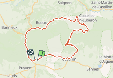
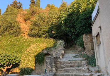
Ruta Bici de montaña de 44 km a descubrir en Provenza-Alpes-Costa Azul, Vaucluse, Lourmarin. Esta ruta ha sido propuesta por DG01.
Descripción
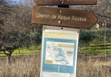
Depuis Cucuron, monter le DFCI (1h30 environ) jusqu’au Mourre Negre, puis descendre le chemin de Marauviere (début quelconque, mais devient ensuite un super single (2-3 passages à pied) jusqu’à Auribeau).
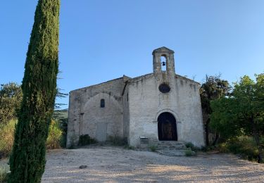
Remonter légèrement jusqu’à la chapelle pour ensuite descendre le long de L’Aigue Brun (magnifique single, mais attention aux randonneurs).
En résumé, tour absolument magnifique pour la beauté des paysages, les singles de qualité, mais exigeant.
Localización
Comentarios
Excursiones cerca
![Excursión Senderismo Vaugines - PF-Vaugines - Cucuron - l'Ermitage - Vaugines - 17.06.2021 - Photo](https://media.geolcdn.com/t/375/260/49a6fcb0-e7e8-4e10-aa10-ef2270b11aa9.jpg&format=jpg&maxdim=2)
![Senderismo Senderismo](https://static1.geolcdn.com/sitytour/trail-icons/101.png)
Senderismo
![](/images/other/stat-length.png)
![](https://static1.geolcdn.com/siteimages/upload/files/16400158638029165_repeat_loop_refresh_sync_direction_icon.png)
![Excursión Senderismo Cadenet - Cadenet -Lourmarin - Photo](https://media.geolcdn.com/t/375/260/f0fee848-9372-4ead-90a1-4f47846561d2.jpg&format=jpg&maxdim=2)
![Senderismo Senderismo](https://static1.geolcdn.com/sitytour/trail-icons/101.png)
Senderismo
![](/images/other/stat-length.png)
![](https://static1.geolcdn.com/siteimages/upload/files/16400158638029165_repeat_loop_refresh_sync_direction_icon.png)
![Senderismo Senderismo](https://static1.geolcdn.com/sitytour/trail-icons/101.png)
Senderismo
![](/images/other/stat-length.png)
![](https://static1.geolcdn.com/siteimages/upload/files/16400158638029165_repeat_loop_refresh_sync_direction_icon.png)
![Excursión Senderismo Cadenet - PF-Cadenet - De Cadenet à Lourmarin - 3 - Photo](https://media.geolcdn.com/t/375/260/a6ee6e4b-3e12-4299-848e-3348098a84d0.jpg&format=jpg&maxdim=2)
![Senderismo Senderismo](https://static1.geolcdn.com/sitytour/trail-icons/101.png)
Senderismo
![](/images/other/stat-length.png)
![](https://static1.geolcdn.com/siteimages/upload/files/16400158638029165_repeat_loop_refresh_sync_direction_icon.png)
![Senderismo Senderismo](https://static1.geolcdn.com/sitytour/trail-icons/101.png)
Senderismo
![](/images/other/stat-length.png)
![](https://static1.geolcdn.com/siteimages/upload/files/16400158638029165_repeat_loop_refresh_sync_direction_icon.png)
![Excursión Senderismo Vaugines - Vaugines - roque rousse. - Vaugines - Photo](https://media.geolcdn.com/t/375/260/6177de4a-3309-4104-9e1d-30cfd59fb2bd.jpg&format=jpg&maxdim=2)
![Senderismo Senderismo](https://static1.geolcdn.com/sitytour/trail-icons/101.png)
Senderismo
![](/images/other/stat-length.png)
![](https://static1.geolcdn.com/siteimages/upload/files/16400158638029165_repeat_loop_refresh_sync_direction_icon.png)
![Excursión A pie Lourmarin - Lourmarin - Cadenet - Lourmarin - Photo](https://media.geolcdn.com/t/375/260/2d53adfc-3504-4117-a8f3-d2bec3eead0d.jpg&format=jpg&maxdim=2)
![A pie A pie](https://static1.geolcdn.com/sitytour/trail-icons/100.png)
A pie
![](/images/other/stat-length.png)
![](https://static1.geolcdn.com/siteimages/upload/files/16400158638029165_repeat_loop_refresh_sync_direction_icon.png)
![Excursión Senderismo Vaugines - Luberon Vaugines Cucuron - Photo](https://media.geolcdn.com/t/375/260/6272fad2-dba5-4d24-99de-fd6c5316cc92.jpg&format=jpg&maxdim=2)
![Senderismo Senderismo](https://static1.geolcdn.com/sitytour/trail-icons/101.png)
Senderismo
![](/images/other/stat-length.png)
![](https://static1.geolcdn.com/siteimages/upload/files/16400158638029165_repeat_loop_refresh_sync_direction_icon.png)
![Excursión Senderismo Cadenet - Cadenet Lourmarin Cadenet - Photo](https://media.geolcdn.com/t/375/260/9ae9fb37-52f2-488e-8d20-dd9900ea5cda.jpg&format=jpg&maxdim=2)
![Senderismo Senderismo](https://static1.geolcdn.com/sitytour/trail-icons/101.png)
Senderismo
![](/images/other/stat-length.png)
![](https://static1.geolcdn.com/siteimages/upload/files/16400158638029165_repeat_loop_refresh_sync_direction_icon.png)