![](/images/other/stat-length.png)
![Excursión Senderismo Savines-le-Lac - boucle arnoud autour de savines - Photo](https://media.geolcdn.com/t/1900/400/a917623f-21c3-4e90-8a30-385f8dd9d5ba.jpg&format=pjpeg&maxdim=2)
boucle arnoud autour de savines
guariso
Usuario
![Longitud](/images/other/stat-length.png)
![Altitud máxima](https://static1.geolcdn.com/siteimages/upload/files/1508320355ic_sort_altitude_max_24dp.png)
![Desnivel positivo](https://static1.geolcdn.com/siteimages/upload/files/1508320355ic_sort_den_pos_24dp.png)
![Km-Effort](/images/other/stat-length.png)
![Altitud mínima](https://static1.geolcdn.com/siteimages/upload/files/1508320355ic_sort_altitude_min_24dp.png)
![Desnivel negativo](https://static1.geolcdn.com/siteimages/upload/files/1508320355ic_sort_den_neg_24dp.png)
![Boucle](https://static1.geolcdn.com/siteimages/upload/files/16400158638029165_repeat_loop_refresh_sync_direction_icon.png)
![Senderismo](https://static1.geolcdn.com/sitytour/trail-icons/101.png)
1h38
Dificultad : Medio
![Escanee este código QR para abrir la excursión en la aplicación SityTrail](https://capi.geolives.com/qq0zvz2zws4bq2lad0pu/sitytour/trails/4132760/qr.png?size=200)
Aplicación GPS de excursión GRATIS
A propósito
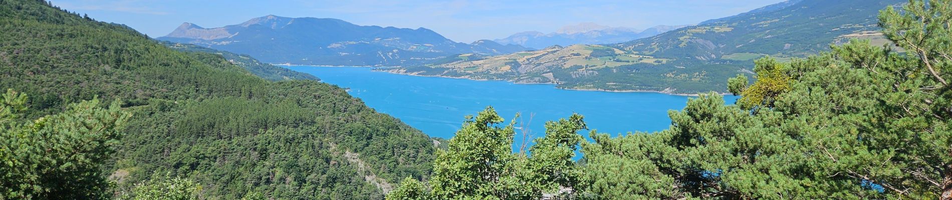
Ruta Senderismo de 7,1 km a descubrir en Provenza-Alpes-Costa Azul, Altos Alpes, Savines-le-Lac. Esta ruta ha sido propuesta por guariso.
Descripción
Le départ peut se faire de n'importe où sur la boucle. C'est pour faire de la marche ou même nordique sur les portions forestières ou course à pieds pour les plus sportifs. Le long du lac est une portion plane qui emprunte le chemin piéton. Attention à la traversée pour aller sur le sentier pierre arnoux. Le sentier monte en sous bois. Jusqu'à la route forestière après 3 bifurcations à gauche puis une à droite. On redescend vers savines pas un petit sentier sur la gauche.
Localización
Comentarios
Excursiones cerca
![Excursión Senderismo Crots - Le Cirque de Morgon - Photo](https://media.geolcdn.com/t/375/260/ext.jpg?maxdim=2&url=https%3A%2F%2Fservices.sitytrail.com%2FGeolivesWS%2FDownloadMedia.ashx%3FTrailID%3D109626%26Media%3D4261_1.jpg)
![Senderismo Senderismo](https://static1.geolcdn.com/sitytour/trail-icons/101.png)
Senderismo
![](/images/other/stat-length.png)
![](https://static1.geolcdn.com/siteimages/upload/files/16400158638029165_repeat_loop_refresh_sync_direction_icon.png)
![Excursión Senderismo Pontis - PONTIS. le dolmen . le Morgonnet . cabane du Jas o l - Photo](https://media.geolcdn.com/t/375/260/d93d41b4-eb7a-4763-938e-68a4d680a655.jpg&format=jpg&maxdim=2)
![Senderismo Senderismo](https://static1.geolcdn.com/sitytour/trail-icons/101.png)
Senderismo
![](/images/other/stat-length.png)
![](https://static1.geolcdn.com/siteimages/upload/files/16400158638029165_repeat_loop_refresh_sync_direction_icon.png)
![Excursión Senderismo Crots - Morgon par le Grand Clot - Photo](https://media.geolcdn.com/t/375/260/2470b249-9732-40d6-87a8-fc728b4285cc.jpg&format=jpg&maxdim=2)
![Senderismo Senderismo](https://static1.geolcdn.com/sitytour/trail-icons/101.png)
Senderismo
![](/images/other/stat-length.png)
![](https://static1.geolcdn.com/siteimages/upload/files/16400158638029165_repeat_loop_refresh_sync_direction_icon.png)
![Excursión Senderismo Puy-Saint-Eusèbe - canal de reyssas jusqu'aux Touisses / retour par le GR Serre-Ponçon via ravin de la pisse - Photo](https://media.geolcdn.com/t/375/260/207bcfa3-5f2f-4889-95d2-ad39c84c3a40.jpg&format=jpg&maxdim=2)
![Senderismo Senderismo](https://static1.geolcdn.com/sitytour/trail-icons/101.png)
Senderismo
![](/images/other/stat-length.png)
![](https://static1.geolcdn.com/siteimages/upload/files/16400158638029165_repeat_loop_refresh_sync_direction_icon.png)
![Excursión Senderismo Pontis - pic de Morgon par les ortals et les traverses - Photo](https://media.geolcdn.com/t/375/260/cb777f72-56d2-4b64-b456-51d964e0cfaa.jpg&format=jpg&maxdim=2)
![Senderismo Senderismo](https://static1.geolcdn.com/sitytour/trail-icons/101.png)
Senderismo
![](/images/other/stat-length.png)
![](https://static1.geolcdn.com/siteimages/upload/files/16400158638029165_repeat_loop_refresh_sync_direction_icon.png)
![Excursión Senderismo Pontis - Le Grand Morgon par la face nord 07/09/23 - Photo](https://media.geolcdn.com/t/375/260/a64e7d52-33b6-427f-a518-e6356f0ffab5.jpg&format=jpg&maxdim=2)
![Senderismo Senderismo](https://static1.geolcdn.com/sitytour/trail-icons/101.png)
Senderismo
![](/images/other/stat-length.png)
![](https://static1.geolcdn.com/siteimages/upload/files/16400158638029165_repeat_loop_refresh_sync_direction_icon.png)
![Excursión Senderismo Crots - Grand Morgon - Photo](https://media.geolcdn.com/t/375/260/c2ea8bef-d143-4c62-a26e-6fbe8e0329c8.jpg&format=jpg&maxdim=2)
![Senderismo Senderismo](https://static1.geolcdn.com/sitytour/trail-icons/101.png)
Senderismo
![](/images/other/stat-length.png)
![](https://static1.geolcdn.com/siteimages/upload/files/16400158638029165_repeat_loop_refresh_sync_direction_icon.png)
![Excursión Senderismo Crots - SityTrail - 2251353 - morgon-par-le-grand-clot - Photo](https://media.geolcdn.com/t/375/260/1bb998f8-1a6a-4350-bb2c-9f136211e7d5.jpg&format=jpg&maxdim=2)
![Senderismo Senderismo](https://static1.geolcdn.com/sitytour/trail-icons/101.png)
Senderismo
![](/images/other/stat-length.png)
![](https://static1.geolcdn.com/siteimages/upload/files/16400158638029165_repeat_loop_refresh_sync_direction_icon.png)
![Excursión Senderismo Pontis - Morgon par les Traverses, retour par les Ortals - Photo](https://media.geolcdn.com/t/375/260/11e2532a-2629-4e4d-ad92-dc03a7dece44.jpg&format=jpg&maxdim=2)
![Senderismo Senderismo](https://static1.geolcdn.com/sitytour/trail-icons/101.png)
Senderismo
![](/images/other/stat-length.png)
![](https://static1.geolcdn.com/siteimages/upload/files/16400158638029165_repeat_loop_refresh_sync_direction_icon.png)