![](/images/other/stat-length.png)
![Excursión Senderismo Le Muy - Bernadette - Photo](https://media.geolcdn.com/t/1900/400/985ef159-9418-40da-ac00-bda8b6b631ed.jpg&format=pjpeg&maxdim=2)
Bernadette
mb83serre
Usuario
![Longitud](/images/other/stat-length.png)
Longitud
8,6 km
![Altitud máxima](https://static1.geolcdn.com/siteimages/upload/files/1508320355ic_sort_altitude_max_24dp.png)
Altitud máxima
80 m
![Desnivel positivo](https://static1.geolcdn.com/siteimages/upload/files/1508320355ic_sort_den_pos_24dp.png)
Desnivel positivo
100 m
![Km-Effort](/images/other/stat-length.png)
Km-Effort
9,9 km
![Altitud mínima](https://static1.geolcdn.com/siteimages/upload/files/1508320355ic_sort_altitude_min_24dp.png)
Altitud mínima
21 m
![Desnivel negativo](https://static1.geolcdn.com/siteimages/upload/files/1508320355ic_sort_den_neg_24dp.png)
Desnivel negativo
104 m
![Boucle](https://static1.geolcdn.com/siteimages/upload/files/16400158638029165_repeat_loop_refresh_sync_direction_icon.png)
Boucle
Sí
Fecha de creación :
2024-07-23 05:48:15.875
Última modificación :
2024-07-23 14:09:16.808
![Senderismo](https://static1.geolcdn.com/sitytour/trail-icons/101.png)
2h15
Dificultad : Medio
![Escanee este código QR para abrir la excursión en la aplicación SityTrail](https://capi.geolives.com/qq0zvz2zws4bq2lad0pu/sitytour/trails/4131438/qr.png?size=200)
Aplicación GPS de excursión GRATIS
A propósito
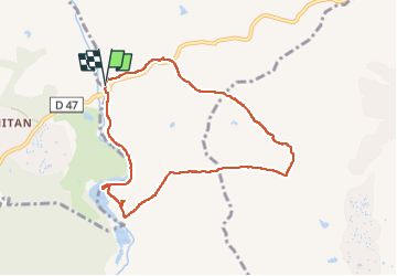
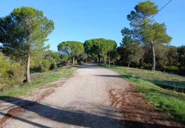
Ruta Senderismo de 8,6 km a descubrir en Provenza-Alpes-Costa Azul, Var, Le Muy. Esta ruta ha sido propuesta por mb83serre.
Descripción
Possibilité de rallonger cette marche.
A partir de 46 faire 44,45,53,66 et retour 69.
On rajoute réduction et rajout faits environ 1,5 Km
Localización
País:
France
Región :
Provenza-Alpes-Costa Azul
Departamento/provincia :
Var
Municipio :
Le Muy
Localidad:
Unknown
Salida:(Dec)
Salida:(UTM)
305233 ; 4819649 (32T) N.
Comentarios
Excursiones cerca
![Excursión Senderismo Le Muy - Pic du Castel Diaou - Fille d'Isnard - Pic Rébéquier - Photo](https://media.geolcdn.com/t/375/260/4f204571-7b19-40b2-95c4-b71e4d308f15.jpg&format=jpg&maxdim=2)
![Senderismo Senderismo](https://static1.geolcdn.com/sitytour/trail-icons/101.png)
Pic du Castel Diaou - Fille d'Isnard - Pic Rébéquier
Senderismo
Muy difícil
(2)
Le Muy,
Provenza-Alpes-Costa Azul,
Var,
France
![](/images/other/stat-length.png)
17,3 km | 26 km-effort
5h 25min
![](https://static1.geolcdn.com/siteimages/upload/files/16400158638029165_repeat_loop_refresh_sync_direction_icon.png)
Sí
![Excursión Senderismo Le Muy - les grottes Baume Renaude - Photo](https://media.geolcdn.com/t/375/260/83f6db30-c43d-4bf1-a9a3-011d52f73567.jpg&format=jpg&maxdim=2)
![Senderismo Senderismo](https://static1.geolcdn.com/sitytour/trail-icons/101.png)
les grottes Baume Renaude
Senderismo
Difícil
(1)
Le Muy,
Provenza-Alpes-Costa Azul,
Var,
France
![](/images/other/stat-length.png)
13,3 km | 18,3 km-effort
5h 13min
![](https://static1.geolcdn.com/siteimages/upload/files/16400158638029165_repeat_loop_refresh_sync_direction_icon.png)
No
![Excursión Senderismo Callas - gorge de Penafore - Photo](https://media.geolcdn.com/t/375/260/19f2f069-7b40-4577-819a-e6663f6d8c61.jpg&format=jpg&maxdim=2)
![Senderismo Senderismo](https://static1.geolcdn.com/sitytour/trail-icons/101.png)
gorge de Penafore
Senderismo
Muy fácil
(1)
Callas,
Provenza-Alpes-Costa Azul,
Var,
France
![](/images/other/stat-length.png)
1,1 km | 1,3 km-effort
1h 33min
![](https://static1.geolcdn.com/siteimages/upload/files/16400158638029165_repeat_loop_refresh_sync_direction_icon.png)
Sí
![Excursión Senderismo Le Muy - Le Castel Diaou - Crête Fille d'Isnard depuis le pont de L'Endre - Photo](https://media.geolcdn.com/t/375/260/be9a20a4-3a2b-4a58-ad48-d15f8920c7dd.jpg&format=jpg&maxdim=2)
![Senderismo Senderismo](https://static1.geolcdn.com/sitytour/trail-icons/101.png)
Le Castel Diaou - Crête Fille d'Isnard depuis le pont de L'Endre
Senderismo
Muy difícil
Le Muy,
Provenza-Alpes-Costa Azul,
Var,
France
![](/images/other/stat-length.png)
22 km | 31 km-effort
7h 4min
![](https://static1.geolcdn.com/siteimages/upload/files/16400158638029165_repeat_loop_refresh_sync_direction_icon.png)
Sí
![Excursión Senderismo Le Muy - Pas des Vaches - Pic rébéquier - Fontaine du Chasseur - Pic Castel Diaou - Photo](https://media.geolcdn.com/t/375/260/2b85ee09-1824-4ac8-a041-9e96b6f63a59.jpg&format=jpg&maxdim=2)
![Senderismo Senderismo](https://static1.geolcdn.com/sitytour/trail-icons/101.png)
Pas des Vaches - Pic rébéquier - Fontaine du Chasseur - Pic Castel Diaou
Senderismo
Muy difícil
Le Muy,
Provenza-Alpes-Costa Azul,
Var,
France
![](/images/other/stat-length.png)
22 km | 30 km-effort
6h 55min
![](https://static1.geolcdn.com/siteimages/upload/files/16400158638029165_repeat_loop_refresh_sync_direction_icon.png)
Sí
![Excursión Senderismo Le Muy - z l'Endre 05-11-24 - Photo](https://media.geolcdn.com/t/375/260/65ef0e16-5892-4283-8ef2-d7b65c70199a.jpg&format=jpg&maxdim=2)
![Senderismo Senderismo](https://static1.geolcdn.com/sitytour/trail-icons/101.png)
z l'Endre 05-11-24
Senderismo
Medio
Le Muy,
Provenza-Alpes-Costa Azul,
Var,
France
![](/images/other/stat-length.png)
6,7 km | 8,1 km-effort
2h 17min
![](https://static1.geolcdn.com/siteimages/upload/files/16400158638029165_repeat_loop_refresh_sync_direction_icon.png)
Sí
![Excursión Senderismo Le Muy - Rocher de Roquebrune, Les 2 frères - Photo](https://media.geolcdn.com/t/375/260/4c3abf35-bd0e-4562-9d28-88f605def60c.jpg&format=jpg&maxdim=2)
![Senderismo Senderismo](https://static1.geolcdn.com/sitytour/trail-icons/101.png)
Rocher de Roquebrune, Les 2 frères
Senderismo
Medio
Le Muy,
Provenza-Alpes-Costa Azul,
Var,
France
![](/images/other/stat-length.png)
7,8 km | 11,2 km-effort
3h 20min
![](https://static1.geolcdn.com/siteimages/upload/files/16400158638029165_repeat_loop_refresh_sync_direction_icon.png)
No
![Excursión A pie La Motte - Massif de la Colle du Rouet 25-09-2024 - Photo](https://media.geolcdn.com/t/375/260/4107a712-55c1-481b-90f6-bb916ccc3554.jpg&format=jpg&maxdim=2)
![A pie A pie](https://static1.geolcdn.com/sitytour/trail-icons/100.png)
Massif de la Colle du Rouet 25-09-2024
A pie
Medio
La Motte,
Provenza-Alpes-Costa Azul,
Var,
France
![](/images/other/stat-length.png)
17,4 km | 25 km-effort
5h 38min
![](https://static1.geolcdn.com/siteimages/upload/files/16400158638029165_repeat_loop_refresh_sync_direction_icon.png)
Sí
![Excursión Senderismo Roquebrune-sur-Argens - 2024-07-31_10h47m55_Randonn_e_juillet - Photo](https://media.geolcdn.com/t/375/260/ext.jpg?maxdim=2&url=https%3A%2F%2Fstatic1.geolcdn.com%2Fsiteimages%2Fupload%2Ffiles%2F1553511878bg_sport_marche.png)
![Senderismo Senderismo](https://static1.geolcdn.com/sitytour/trail-icons/101.png)
2024-07-31_10h47m55_Randonn_e_juillet
Senderismo
Medio
(1)
Roquebrune-sur-Argens,
Provenza-Alpes-Costa Azul,
Var,
France
![](/images/other/stat-length.png)
7,3 km | 8,4 km-effort
1h 55min
![](https://static1.geolcdn.com/siteimages/upload/files/16400158638029165_repeat_loop_refresh_sync_direction_icon.png)
Sí